|
Another exceptional aquatint print from James Jenkins The Naval Achievements of Great Britain. On 2 May 1795 Rear Admiral George Murray sent Captain Alexander Cochrane in Thetis, together with Hussar, to intercept three French supply ships reported at Hampton Roads. At daybreak on 17 May the British came upon five ships 20 leagues West by South from Cape Henry. The French made a line of battle to receive the British frigates. An action commenced, with three of the French vessels eventually striking their colours. Thetis took possession of the largest, which turned out to be Prévoyante, pierced for 36 guns but only mounting 24. Hussar captured a second, Raison, pierced for 24 guns but only mounting 18. An hour after she had struck, Prévoyante's main and foremast fell over the side. In the battle, Thetis had lost eight men killed and nine wounded; Hussar had only two men wounded.  Above: Capture of La Prevoyante and La Raison, May 17th 1795. Published June 1st 1816 at 48 Strand for J. Jenkins Naval Achievements. From The Naval achievements of Great Britain and Her Allies from 1793 to 1817 by J. Jenkins.
Excerpt from the written account as published: MAY 17, 1795. COPY of a Letter from Captain COCHRANE, 0f his Majesty's Ship Thetis, to Evan NEPEAN, Esq. SIR, Be pleased to acquaint the Lords Commissoners of the Admiralty, that, in consequence of orders from Rear-Admiral Murray to cruise off the Chesapeak, to intercept the three French store-ships then lying in Hampton roads and ready for sea, I proceeded on the 2d instant with H. M. S. Hussar, and on the 17th, at daybreak, Cape Henry bearing E. by S. distant 20 leagues, we discovered five sail of ships standing to the N. W. with their larboard tacks on board. We soon perceived that they were ships of force: two of them appeared to carry from 28 to 30 guns on the main-deck, one of which had lower-deck ports; the three others from 20 to 24 guns. On observing us standing towards them, they formed a line of battle ahead, and prepared to receive us. At nine a. m. I made the Hussar a signal to prepare to engage the second ship of the enemy's van, intending in the Thetis to attack the centre ship, which appeared the largest, with the two others that formed the rear carrying a broad pendant. By this time we had got within half musket-shot, when the firing commenced on the side of the enemy, which was soon afterwards returned by his Majesty's ships. Before eleven we had closed with the enemy, and the Hussar had compelled the commodore and his second ahead to quit the line (see the annexed engraving), and make sail to the E. S. E. The fire of both ships then fell upon the centre ship and those in the rear. At a quarter before twelve the three ships struck their colours: the two in the rear attempted, notwithstanding, to make of, one of which was soon brought to by the Hussar. Within an hour after the largest ship struck, her main and foremasts went over her side; on taking possession, she proved to be La Prevoyante, pierced for 26 guns on the main-deck, with four other ports, which can be cut out at pleasure, and ten ports below: she had only 24 mounted, part of which they shifted over during the action. The ship the Hussar has taken possession of is called La Raison, carrying 18 guns, but pierced for 24, which, with the other three, had escaped from Guadaloupe on the 25th ult. and were bound to one of the American ports, to take ina cargo of provisions and naval stores for France. At half past ten the enemy hoisted their colours, the second ship in the van . . . How to Identify the Prints: The original prints from "The Naval Achievements of Great Britain. From the Year 1793 to 1817" are aquatint engravings on a medium weight wove paper. All the plates identify at bottom left Painted by T. Whitcombe and bottom right T. Sutherland (sculpt) who produced the aquatint engravings. Some plates were engraved by Jeakes and Bailey after Whitcombe. Each plate is accompanied by text pages describing the action, often with lists of ships captured or sunk, and excerpts from contemporary bulletins, dispatches, letters, and speeches. The first edition appeared in 1817. Early issues have watermarks of J. Whatman with the undated watermark IIS&S on some plates. The vignette title page was uncoloured in the first issue. The approx engraved image area of the plates are 7" x 10.25" (175mm x 260mm). Engraved plate mark area is approx 8.5 x 11.75 (215mm x 300mm). The folio sheet size is approx 11.5" x 14" (290mm x 355mm). You can see more prints from Jenkins The Naval Achievements of Great Britain, From the Year 1793 to 1817 HERE. If you're interested in a specific print and you cannot see it on my website please feel free to message me Founded by Nathaniel Currier in 1835, Currier & Ives was the major poster firm of the nineteenth century. James Merritt Ives joined Currier in 1857, and the two produced some of the most popular images of the period. Together they published thousands of prints of scenes that are still sought by collectors today. The firm Currier and Ives described itself as "Publishers of Cheap and Popular Prints". At least 7,500 lithographs were published in the firm's 72 years of operation. 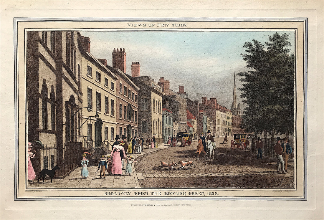 Above: Original Engraved Lithograph VIEWS OF NEW YORK - BROADWAY FROM THE BOWLING GREEN, 1828 Published CURRIER & IVES, 152 Nassua Street, New York c1857. A hand coloured lithograph as issued on Heavy Laid Paper, good impression and clear plate mark. Painted by J Bennett & here engraved by R. J. Hutchinson. (Very few prints carried the original artist name, this one does). Engraved area size: 10.25" X 16.5" (260mm x 419mm) Blank to verso. This is a rare view of Broadway as seen from the Bowling Green end in 1828. The figures depicted on the street scene are all fashionable dressed, with simple but finely tailored clothing, the men wear black top hats and the women and children wear bonnets or simple straw hats with garlands. A few dogs run into the street, carriages are parked along the side of the road, and a couple is riding on horseback along the street. From a series of "Views of New York" published by Currier & Ives. This exceptional print is available now. You can see more info HERE Happy Hunting! Collecting Antique Maps - Reference Library - Blaeu's The Grand Atlas of the 17th Century World3/11/2021 Another book recommendation for novice antique map collectors. I remember the first couple of maps I bought at auction were maps by Blaeu. At the time I was at the auction to buy what could best be describe as an elaborate floor standing ecclesiastical or masonic brass oil lamp which some idiot had converted to electric! I fully restored eventually. While at that auction these two maps had caught my eye and I just new they were special and I bought them. At the time I didn't even know the name Blaeu. From then on I've been hooked, I've learnt a lot about maps and still love the cartographic work of the Blaeu family. With this in mind this book is a must have and you can find copies on the internet not overly expensive. As previously mentioned I recommend developing a reference library geared towards your specific subject of interest. The benefits are many and the knowledge you gain will help you with the decision making process when it comes to future investments for your map collection. 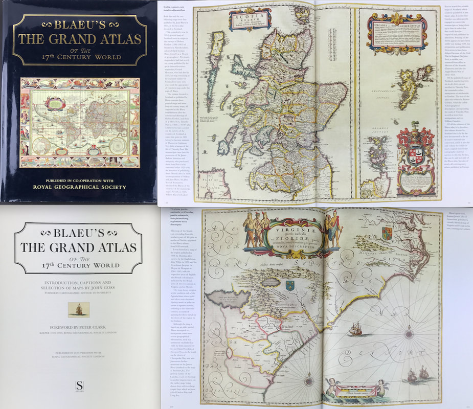 Above: Blaeu's The Grand Atlas of the 17th Century World. INTRODUCTION BY JOHN GOSS, FOREWORD BY PETER CLARK, KEEPER(1989-92), ROYAL GEOGRAPHICAL SOCIETY. Publisher: Royal Geographical Society London 1997.
This edition of Blaeu's 17th-century atlas includes the finest maps selected from the original nine volumes. These contained almost 600 maps, covering the entire world as it was known at that time. John Goss has supplied extended captions for the benefit of a modern readership. JOAN BLAEU'S THE ATLAS MAJOR, first published in 1662, is still the largest atlas ever produced. Over six hundred maps portray the world as it was known in the middle of the 17th century with its great empires, far-off exotic kingdoms and lands of legend. The embellishment and decoration of these maps, unsurpassed in their beauty and sumptuous detail, bring to life a long-lost age of mapmaking. These books are a great resource when it comes to understanding about maps and learning about your subject of interest. More info on "Blaeu's The Grand Atlas of the 17th Century World" can be found HERE Happy Reference Book Hunting! Collecting 18th Century Maps - Matthäus Seutter Map of the East Indies - More Tips for the Novice!3/10/2021 Back on my "More Tips for the Novice" theme its fair to say the eighteenth century has much to offer the map collecting enthusiast. Much of the world's cartography was still unmapped at the beginning of the century and the existence of an Antarctic continent was not known, while much of the Pacific remained undiscovered by Europeans until the end of the century. As the century advanced there was a resurgence in Germany in map publishing with the firms of Homann, Seutter and Lotter. Matthäus Seutter (1678-1757) was one of the most important and prolific German mapmakers who began his career apprenticed as an engraver with J.B. Homann. Sometime in the early 18th century Seutter left Homann to establish his own independent cartographic publishing firm in Augsburg. Though he struggled in the early years of his independence, Seutter’s engraving skill and commitment to diversified map production eventually gained him a substantial following. In 1732 he was honoured by the German Emperor Charles VI with the title of “Imperial Geographer”. His most famous work is Atlas Novus Sive Tabulae Geographicae, published in two volumes ca. 1730. 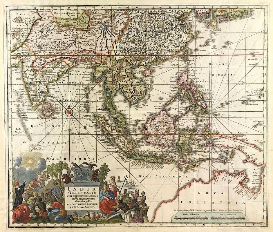 Above: Matthäus Seutter, India Orientalis cum Adjacentibus Insulis Nova Delineatione ob oculos posita . . c1730/42
This is a nice example of Seutter's scarce map of the East Indies and part of Australia, from the Atlas Novus. The map extends from Japan and Persia in the North, to the Maldives and Australia and the Ladrones in the South and West. One of the most notable features of the map is that Australia continues to be attached to Nova Guinea, albeit with some hesitation, as the image extends outside the inner neatline to convey this information - this in spite of the fact that there are 20 or more place names along Australia's Northern Coastline. The detail throughout Southeast Asia is excellent and the print style typically strong. The cartouche is one of the more ornate Seutter cartouches, with elaborate scenes from sea, land, jungle and mythology . This map is currently up for sale at a reduced price as part of my "Mad as a March Hare" Sale. More information HERE As I've mentioned before reproduction coats of arms are sold by just about every online outlet as a quirky addition to your collection of home accessories. You've only got to type in 'coat of arms' to Amazon to see what gets thrown at you and I'm not going to elaborate. At a basic level a coat of arms is a shield with symbols, animals and colours that represent a family, person or group of people. Get the right thing and yes it can add to your decor. Thankfully the more serious heraldic print collectors are still alive and well. Early etchings and copper engraved coats of arms from the 18th century are very collectable. Heraldic Achievement's from Baronageium Genealogicum by Joseph Edmondson c1764 is a favourite and when accurately hand coloured in water colour in accordance with the Heraldic codes are some of the best. 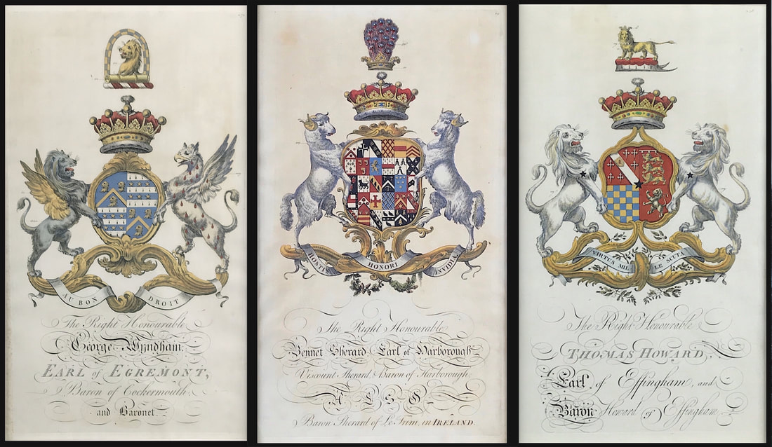 The original prints from Baronageium Genealogicum were copper plate engraved on hand laid paper. This kind of paper has a very distinct appearance and is identified by the visible lines seen in the paper when held up to a bright light. You can actually feel the lines and slight roughness when you touch this kind of paper. The original prints dimensions are width 10.75" x height 18”. If you find them coloured its good to check the colouring is correct in accordance with the Heraldic Codes. Most of this information is available online. Happy Hunting! More Coats of Arms from Baronageium Genealogicum by Joseph Edmondson c1764 available HERE - I have a few available in my current "Mad as a March Hare" Sale! Another print from Jenkins The Martial achievements of Great Britain and Her Allies from 1799 to 1815. Below the print is a short excerpt from the original written account as published with the print. The Battle of Talavera was fought just outside the town of Talavera de la Reina, Spain some 120 kilometres southwest of Madrid, during the Peninsular War. At Talavera, an Anglo-Spanish army under Sir Arthur Wellesley combined with a Spanish army under General Cuesta in operations against French-occupied Madrid. After several of their assaults were bloodily repulsed on the second day, the French retreated toward Madrid leaving the battlefield to the Anglo-Spanish army. Events soon compelled Wellesley, who was soon appointed Viscount Wellington, to fall back toward his base in Portugal. 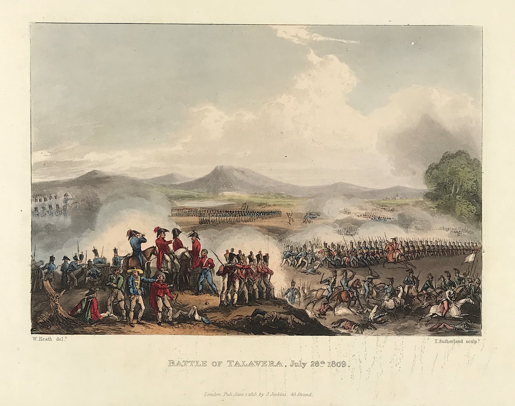 Above: Battle of Talavera, July 28th, 1809. London Published June 1st 1815 by J. Jenkins, 48 Strand. From The Martial achievements of Great Britain and Her Allies from 1799 to 1815 by James Jenkins
Excerpt from the written account as published: THE BATTLE OF TALAVER A, JULY 28, 1809. IN this battle the allied armies of Great Britain and Spain were opposed to more than double their number, the enemy's force consisting of the corps of Marshal Victor and General Sebastiani, of 7 or 8000 of the guards of Joseph Buonaparte, and the garrison of Madrid; the whole commanded by Joseph Buonaparte, assisted by Marshals Jourdan and Victor, and General Sebastiani. The annexed view represents the position. taken up by the troops at Talavera, extending more than two miles: the ground where the British army was stationed, is upon the left, commanded by a height; there is a valley between this height and a range of mountains still fàrther upon. the left. The Tagus is seen in the distance. Extract from the Dispatches received by Lord Ficount CASTLEREAGH from Lieutenant-General Sir ARTHUR WELLESLEY, dated Talavera, July 20. The general attack began by the march of several columns of the enemy's infantry into the valley, with a view.to attack the height occupied by Major-General Hill. These columns were immediately charged by the first German light dragoons and 23d dragoons, under the command of General Anson, directed by Lieutenant-General Payne, and supported by General Fane's brigade of heavy cavalry; and although the 23d dragoons suffered severely, the charge had the effect of preventing the execution of that part of the enemy's plan. At.the same time he directed an attack upon Brigadier. General A. Campbell's position, in the centre of the combined armies and on the right of the British. The attack was most successfully repulsed by Brigadier-General Campbell, supported by the king's regiment of Spanish cavalry; two battalions of Spanish infantry and Brigadier-General Campbell took the enemy's cannon. The brigadier-general mentions particularly the conduct of the 97th, the 2d battalion 7th and 2d battalion 59d regiments ; and I was highly satisfied with the manner in which this part of the position was defended. An attack was also made at the same time upon Lieutenant-General Sherbrooke's division, which was on the left and centre of the first line of the British army. This attack was most gallantly repulsed.by a charge with bayonets by the whole division; but the brigade of Guards, which were on the right, having advanced too far, they were exposed on their left flank to the fire of the enemy's battery and of their retreating columns, and the division was obliged to retire towards the original position, under cover of the second line of General Cotton's brigade of cavalry, which I had moved from the centre, and of the lst battalion... How to Identify the Prints: The original prints from The Martial achievements of Great Britain and Her Allies from 1799 to 1815 are aquatint engravings on a medium weight wove paper. Plates also exist that were printed on India Paper. They should clearly identify bottom left W. Heath (delt) who did the drawings and bottom right T. Sutherland (sculpt) who produced most of the aquatint engravings with some by D. Havell, M. Dubourg and J. Hill. Each plate has the date of publication and the name of the publisher beneath the engraved title. The approx engraved area of the plates are 8.5" x 7.75" (215mm x 195mm) including the engraved title text. Engraved plate mark area is approx 8.5 x 11.75 (215mm x 300mm). The large sheet size is approx 11.5" x 14" (290mm x 355mm). You can see more prints from Jenkins The Martial achievements of Great Britain and Her Allies from 1799 to 1815 HERE. If you're interested in a specific print and you cannot see it on my website please feel free to message me. Collecting Antique Maps - Reference Library - Maps and Charts Published in America Before 18003/8/2021 Another book recommendation for novice antique map collector. As previously mentioned I recommend developing a reference library geared towards your specific subject of interest. The benefits are many and the knowledge you gain will help you with the decision making process when it comes to future investments for your map collection. When first published in 1969 by Yale University Press, this Bibliography represented the first attempt to describe the entire known cartographical contribution of the American press prior to 1800 and as such provided an exhaustive and annotated listing of great value to the historian and cartographer.  Above: Maps and Charts Published in America Before 1800 A Bibliography - Revised Edition by James Clements Wheat and Christian F. Brun. The book includes not only the maps and charts published separately but also those used as illustrations in books and pamphlets and from other sources such as atlases, gazetteers, almanacs, and magazines. Intended originally as a descriptive list of American printed maps and charts in the William L. Clements Library of American History, University of Michigan, the project was enlarged to include all such maps located in the original map collections of the United States and Great Britain. These books are a great resource when it comes to understanding about maps and learning about your subject of interest. More info on "Maps and Charts Published in America Before 1800" can be found HERE Happy Reference Book Hunting! A selection of original aquatint prints from James Jenkins: "The Martial Achievements of Great Britain and Her Allies from 1799 to 1815." Battle of St Jean De Luz 1813, Siege of St Sebastian 1813, Battle of Vittoria, Bringing in the Prisoners and Battle of Morales 1813. These are just four of the exceptional aquatint prints available now in my March Sale. Included with each print is the original folio printed text pages account of the action as first published with the prints by James Jenkins. Rare prints and very collectable. 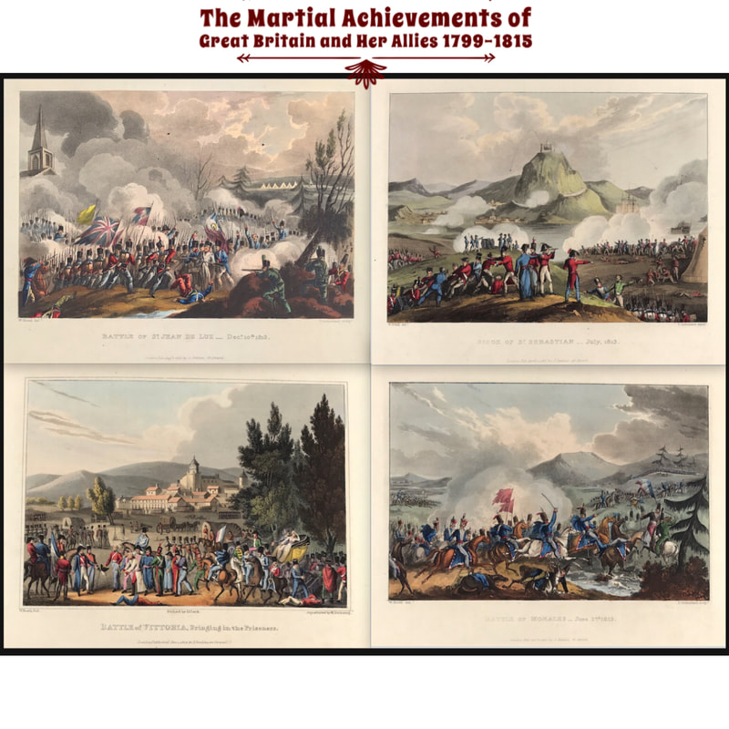 Above: Top Left: Battle of St Jean De Luz 1813. Top Right: Siege of St Sebastian 1813. Bottom Left: Battle of Vittoria, Bringing in the Prisoners Bottom Right: Battle of Morales 1813.
Included with each print is the original folio printed text pages record of the action as first published with the prints by James Jenkins. Now scarce prints and very collectable. Here is the link to see more of these superbly executed prints. Most Painted by Thomas Whitcombe with the aquatint engravings by Thomas Sutherland. Here is the link to see more prints: "The Martial Achievements of Great Britain and Her Allies from 1799 to 1815." Collecting Antique Prints - The Naval Achievements of Great Britain From the Year 1793 to 18173/6/2021 A selection of original aquatint prints from James Jenkins: "The Naval Achievements of Great Britain From the Year 1793 to 1817" These are just four of the exceptional aquatint prints available now for sale in my "Mad as a March Hare" Sale! 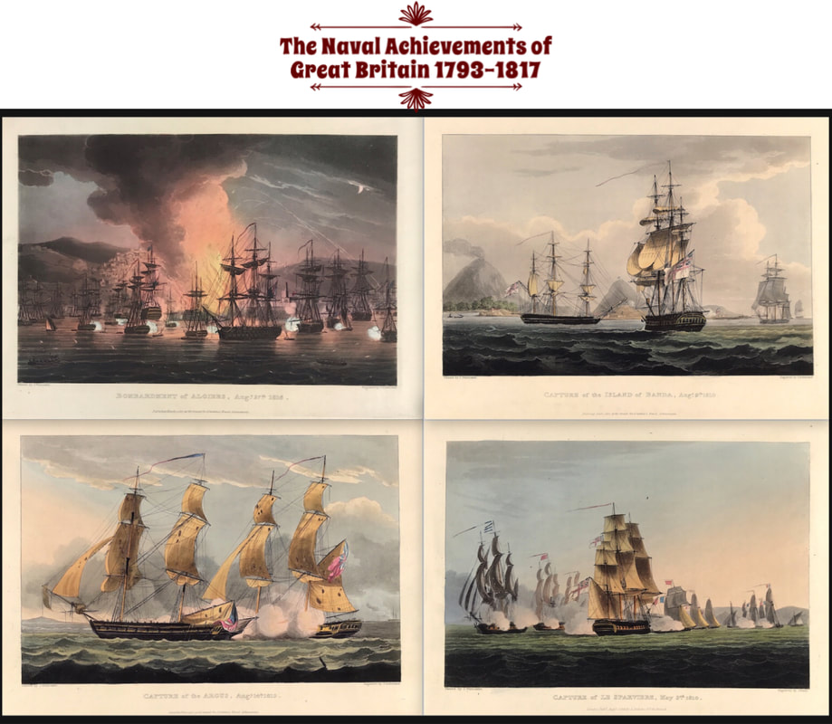 Above: Top Left: Bombardment of Algiers 1816. Top Right: Capture of the Island of Banda 1810. Bottom Left: Capture of the Argus 1813. Bottom Right: Capture of Le Sparviere 1810.
Included with each print is the original folio printed text pages record of the action as first published with the prints by James Jenkins. Now scarce prints and very collectable. Here is the link to see more of these superbly executed prints. Most Painted by Thomas Whitcombe with the aquatint engravings by Thomas Sutherland. Here is the link to see more prints: "The Naval Achievements of Great Britain" The work of an English landscape painter and German aquatint engraver always worth a mention is well illustrated in this print. Joseph Farington RA was an 18th-century English landscape painter and diarist. Joseph Constantine Stadler a British painter and aquatint engraver of German origin active in London in 1780-1812. He engraved Joseph Farington's drawings for History of the River Thames by William Combe (1794-1796). This is the beautiful print of Court Garden and Great Marlow. 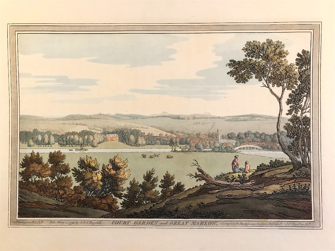 Above: Court Garden & Great Marlow c1793 by Farington, Stadler col. From Joseph Farington's (1747-1821) 'History of the River Thames', 1794.
'History of the River Thames' was a two volume publication including 74 original aquatint prints with hand colour. Illustrations drawn by Joseph Farington and engraved in aquatint by Joseph Constantine Stadler and finished with hand colour. The works were published by J & J Boydell of London, then located at Shakespeare Gallery, Pall Mall and at 90 Cheapside. The publication is noted as one of the grandest and most important books on the Thames. "although not the first coloured aquatint book, it was the first major one, and it was to set an example for the type of illustration that was to enjoy widespread popularity in England for some forty years" - Bruntjen (John Boydell 1719-1804). You can see more prints from 'History of the River Thames' HERE. Another exceptional aquatint print from James Jenkins The Naval Achievements of Great Britain. The Action of 10 April 1795 was a minor naval engagement during the French Revolutionary Wars in which a squadron of French Navy frigates was intercepted by a British battle squadron under Rear-Admiral John Colpoys which formed part of the blockade of the French naval base of Brest in Brittany. In this illustration, British maritime painter Thomas Whitcombe captures the intense battle preceding Britain’s victory in the “Action of 10 April 1795.” The French Revolutionary Wars (1792-1802) and Napoleonic Wars (1803-1815) saw many naval engagements between Britain and France. In this skirmish, a group of French Navy frigates were intercepted by a British battle squadron. The French ships split up, but after a pursuit and fierce battle by Britain’s HMS Astraea, La Gloire was seized. 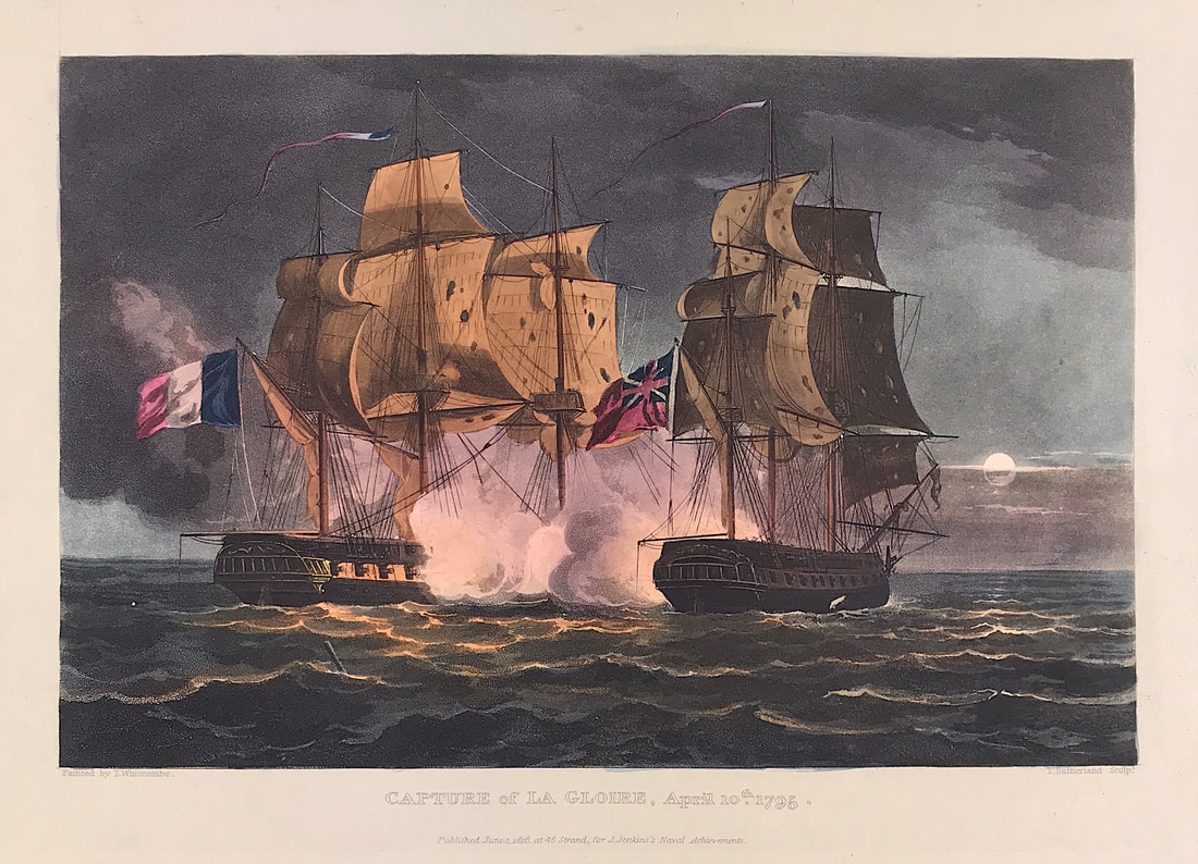 Above: Capture of La Gloria, April 10th 1795. Published June 1st 1816 at 48 Strand for J. Jenkins Naval Achievements. From The Naval achievements of Great Britain and Her Allies from 1793 to 1817 by J. Jenkins.
Excerpt from the written account as published: CAPTURE OF LA GLOIRE, APRIL 10, 1795. THE following is an extract of a letter from Rear-Admiral Colpoys to Evan Nepean, Esq. Secretary to the Admiralty, dated on board his Majesty's ship London, at Spithead, April 16, 1795: Please to acquaint the Lords Commissioners of the Admiralty of my arrival here with his Majesty's ships under my command. That on the 29th March, Le Jean Bart, a French corvette of 20 guns and 120 men, bound to Brest, was captured by his Majesty's ships Cerberas and Santa Margaretta. She had been charged with dispatches from the French minister in America. That on the 30th, the Robust recaptured the Caldicot of Chepstow, for Barcelona, bound to She was taken 18th March, off Cape St. Vinecent, by six French ships of the line, two Guernsey. That on the 10th instant, we discovered and gave chase to three French frigates, which soo shaped different courses. I made the signal to follow the two which pointed most to the westward. The Astrea, Lord Henry Powlet, with his aceustomed promptitude and attention, kept after the largest and seemingly best goer of the three, with which he closed about ten o'clock at night, and obliged her to surrender after a well-fought action of fifty-eight minutes, which does great credit to his lordship's good conduct. The particulars are in his lordship's letter to me, which accompanies this. COLPOYS. (Signed,) P.S. The Robust joined me off the Isle of Wight. Captain Thornborough reports, that La Gentille, of 40 guns, was taken on Saturday last by the Hannibal, but that La Fraternité escaped. How to Identify the Prints: The original prints from "The Naval Achievements of Great Britain. From the Year 1793 to 1817" are aquatint engravings on a medium weight wove paper. All the plates identify at bottom left Painted by T. Whitcombe and bottom right T. Sutherland (sculpt) who produced the aquatint engravings. Some plates were engraved by Jeakes and Bailey after Whitcombe. Each plate is accompanied by text pages describing the action, often with lists of ships captured or sunk, and excerpts from contemporary bulletins, dispatches, letters, and speeches. The first edition appeared in 1817. Early issues have watermarks of J. Whatman with the undated watermark IIS&S on some plates. The vignette title page was uncoloured in the first issue. The approx engraved image area of the plates are 7" x 10.25" (175mm x 260mm). Engraved plate mark area is approx 8.5 x 11.75 (215mm x 300mm). The folio sheet size is approx 11.5" x 14" (290mm x 355mm). You can see more prints from Jenkins The Naval Achievements of Great Britain, From the Year 1793 to 1817 HERE. If you're interested in a specific print and you cannot see it on my website please feel free to message me Another book recommendation for novice antique map collector. As previously mentioned I recommend developing a reference library geared towards your specific subject of interest. The benefits are many and the knowledge you gain will help you with the decision making process when it comes to future investments for your map collection. If North America is of interest to you then this one is for you. The mapping of America focuses on the development of cartography and the geography, territorial expansion, and demographic, political, scientific, and industrial growth of North America are recorded in maps from the sixteenth century to the present. 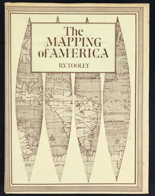 Above: R. V. Tooley's Mapping of America. Publisher: Holland Press Cartographica 2 & North American Distribution by W. Graham Arader III.
This publication was the second volume in the Holland Press Cartographica series and followed the style and format of volume one. Several of the articles are contributed by Ronald Tooley's friends: Coolie Verner with his Yorktown Campaign and Smith's Virginia; Tony Campbell's revised article on the Jansson-Visscher Maps of New England; Stevens and Tree's Comparative Geography and Skelton's Marine Survey's of James Cook in North America, 1758-1768. Most of the articles were previously published in the Map Collectors Series. An occasional correction or addition has been added, two new articles by Tooley included on The Mapping of the Great Lakes and the identification of the Maps of America in the various editions of the Theatrum of Ortelius respectively, and a comprehensive index to all the numbers and plates supplied. These books are a great resource when it comes to understanding about maps and learning about your subject of interest. More info on Tooley's The Mapping of America can be found HERE Happy Reference Book Hunting! |
LEARN ABOUT MAPS Where to Start? The Paper Earliest Maps Whats on the Paper? Rectum & Recto Marketing Devices Why Changing Faces? What is Ornamentation? Why all those lines? The Embellishment Story Illogical Prices Explained A Reference Library CLICK THE BOOK
Get the FREE Guide!
COLLECTING MAPS
Size Matters! Celestial Maps Strip Road Maps Sea Charts On the River of Life Projections The Sea Monsters Thematic Maps Town Plans Buy with Confidence. . .

More Top Tips for the Novice. Click the book to find out more . . .
COLLECTING PRINTS
Views of River Thames
Views of London Shipping & Craft Meet the Fairies Maritime Naval Military Battles Botanical Historic Churches Historic Views of Rome Archives
October 2023
|
kevin@raremapsandprints.co.uk
+44 7788 628706