|
What is it about living by a river? For me I love being 'far from the madding crowd' I love the peace and tranquility that comes with walking in open countryside by the river. Having time to gather your thoughts, or clear you head, whichever is required. Maybe you feel the same about being by a river? 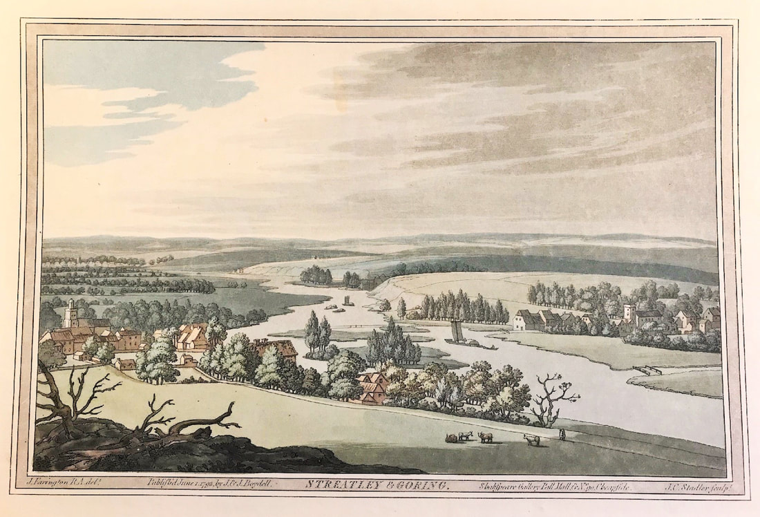 I'm a bit of a nomad so I tend to move home often. My wife says to me 'you're a Sagittarius' what do you expect? In the last 50 years I've lived close to the River Thames three times. Way back in the mid 70's I used to live in Goring on Thames, beautiful part of the river. I've lived in Richmond, London right on the river and Marble Hill Park in a beautiful conservation area. Now I live near Marlow in Buckinghamshire and walk the river as often as I can. 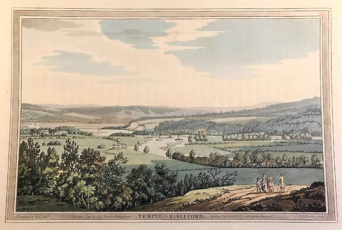 My love of the river mixed with my love of aquatint prints leads me to sharing these landscape views with you. These aquatint plates were produced for the Boydells' major colour publication 'History of the River Thames'. The two volumes originally published in 1794-6 contained sevent-six plates aquatinted by J.C. Stadler after the watercolours of Joseph Farington. 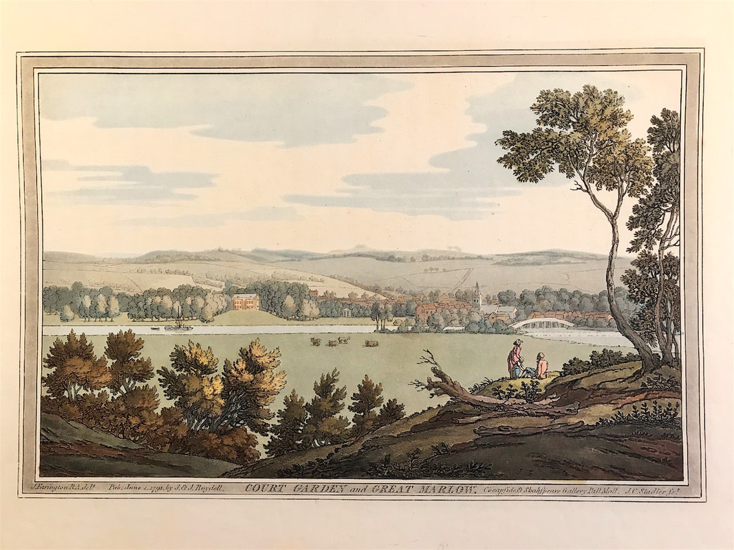 John Boydell, a land surveyor in the employment of his father, was inspired by an engraving by W.H. Toms to leave his home in Shropshire about 1750 and walk to London to apprentice himself to Toms. After six years, Boydell set up his own shop and thus began his career as one of the greatest of print publishers. One of John's later projects, published with Josiah his brother, was this series of views of the Thames River Valley. These prints are excellent examples of the art of aquatinting, and they provide an intimate look at the heart of England during the late eighteenth century. Enjoy! If you're fortunate to live near a river, don't leave it to long before you take your next walk . . . . You can see more from the series of prints HERE Where a selection of the plates are available.
Maps are prized from around the world for all kinds of reasons, their beauty, historical significance, the stories they tell even the mapmaker or cartographer can play a role in an individuals reason for collecting! If Welsh map engravers are your thing then the work of Thomas Bowen will be of interest. 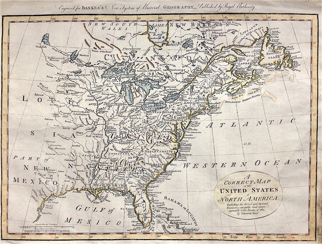 This map is of the "United States of North America. Including the British and Spanish Territories, carefully laid down agreeable to the Treaty of 1784." the work of Welshman Thomas Bowen. Engraved for Bankes's New system of universal geography, published by royal authority. Thomas Bowen (1749-1790) was a Welsh engraver of maps and charts. He was the son of Emanuel Bowen (1720-17670) the map engraver to George II of England and Louis XV of France. Bowen is highly regarded for producing some of the largest, most detailed and accurate maps of his era. These highly attractive maps were also worked on by his son Thomas. In spite of his royal patronage and renown, Emanuel Bowen like many cartographers of his day, died in poverty. His son Thomas continued on the business however a similar outcome befell him and he died in Clerkenwell Workhouse in 1790. Finding maps with the name of Welshman Thomas Bowen noted as engraver or geographer is not impossible but finding this edition of the United states of North America is a little bit special. So if maps of North America are of interest to you or you have a hankering for Welsh mapmakers this may just be what you're looking for! iechyd da This map is currently available, more info HERE
Collecting rare landscape prints remains popular for many even in a tech filled world. These topographical prints appeal to a wide range of interests, they remain collectors items, make wonderful decorative gifts and for some are an investment. Aquatint may be something new to you, you may be surprised to hear it actually dates back to the mid-seventeenth century but really became a popular technique in around 1770. At the time aquatint was the perfect solution to reproducing landscape images, all in keeping with the popularity of watercolour painting at the time. Beauty is in the eye of the beholder the saying goes. The truth is you the observer get to decide what is beautiful, so see what you think of Daniell's work. It's widely accepted one of the most impressive figures in the history of aquatinted topography is William Daniell. Born in 1769, William was the eldest son of the landlord of the Swan Inn at Chertsey, Surrey. By the time he was 15 years of age Daniell's uncle Thomas took him to India where they spent years touring, painting and sketching. 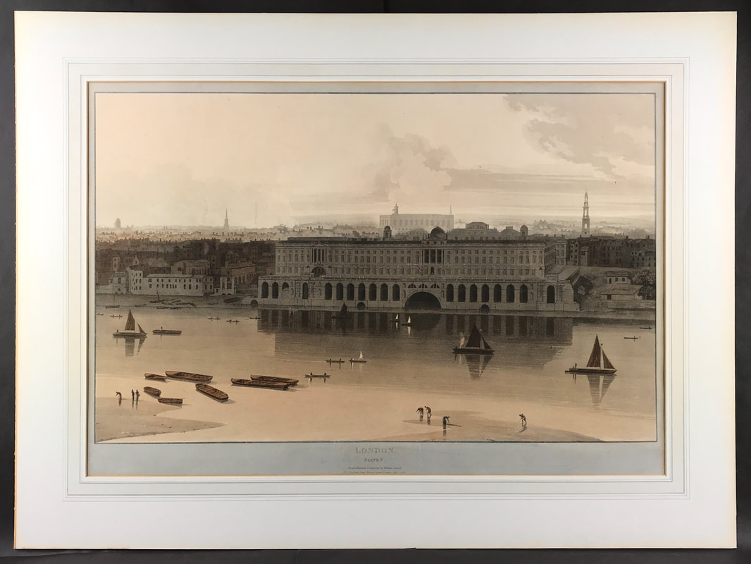 The scarce print shown above is one of six superb views of London produced by Daniell in 1804 showing Somerset House before the embankment. 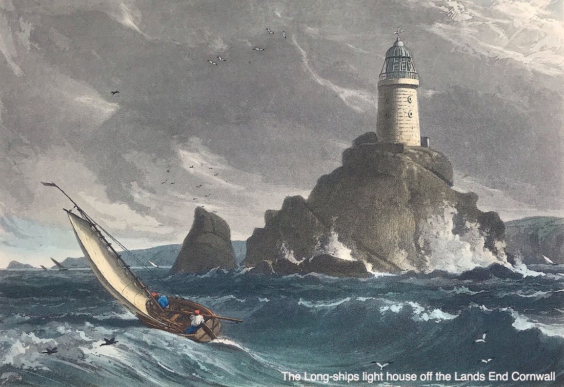 Prints more easy to find and popular are from his work "Voyage around Great Britain." All the illustrations were hand coloured aquatints, drawn and engraved by Daniell. The aquatints were initially printed in brown and grey-blue and the rest of the colouring was added by hand by a team employed by William Timms of Hampstead Road, London. The work took eleven years to complete. Starting at Land's End travelling up the northern coast of Cornwall, the coastline of Wales, north west England, Scotland, some of the islands and back down the east coast of England and then on back along the south coast returning to Land's End. 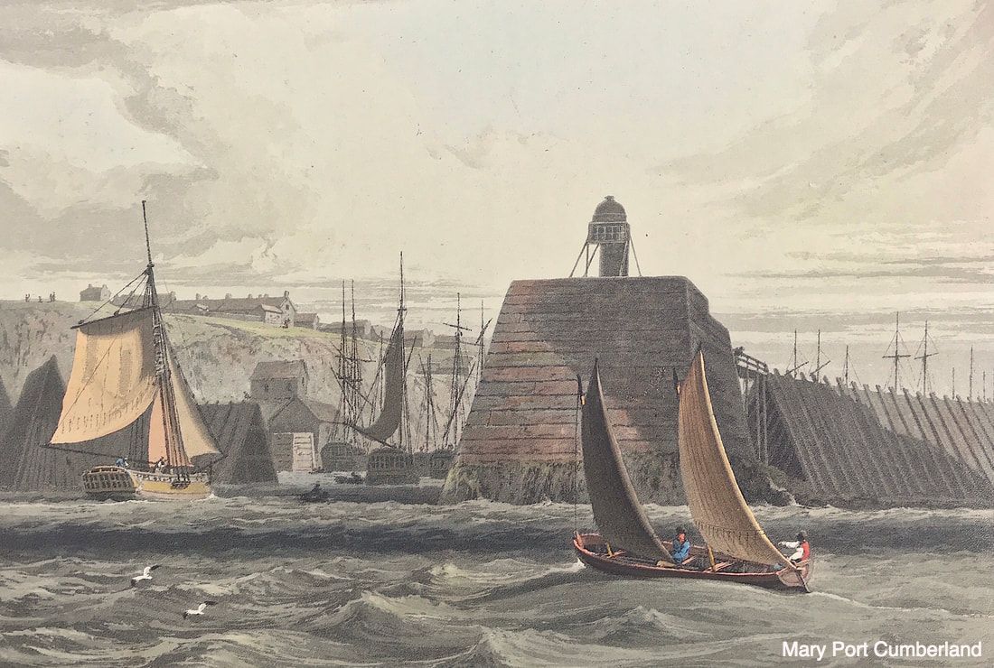 The 308 hand-coloured aquatints were accompanied by a descriptive text written for the first two volumes by Richard Ayton. A set of the Entire 'Voyage' sold for £60 or one and a half times what a fisherman or a sailor aboard a merchant ship could expect to earn in a year at the time! The quality of colouring is exceptional on original plates, delicate and restrained. If the coast of Great Britain is of interest to you then I can recommend none better than William Daniell aquatints. His now very scarce superb views of London, produced in larger folio size are very collectable, when you can find them! Enjoy the hunt! The scarce aquatint print of Somerset House is available HERE
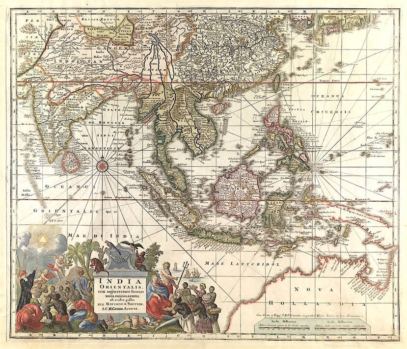 If you're new to collecting antique maps one of the first things that confuses the novice is the term 'original map'. This is compounded by the fact that many maps are attributed to differing people, sometimes the cartographer or the engraver, sometimes to the publisher. Often map dealers will simply use the most famous name associated with the map. So what exactly is an original? If there are many, how can they all be original? It's simple, when it comes to antique maps as with prints the term original refers to a print pulled from a plate or block that was made at a specific time in history. If a run of 100 prints were pulled from a copperplate of a c1700 map then each is an original. Today we are plagued with online sites saturated with reproductions of antique maps and prints. These reproductions are copies made by some other modern method more recent. Price alone should indicate as to original or reproduction but for those new to collecting its wise to do some basic research and be able to distinguish the different processes used in map making. This will aid you in making the right call when it comes to buying. 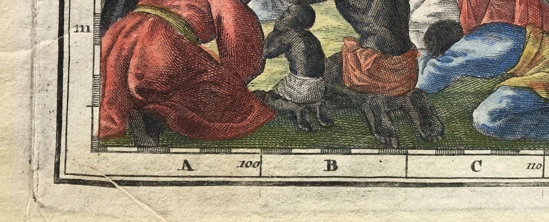 To keep this post brief and give you something of a simple place to start if you're interested in maps made between c1600 to late c1700 these antique maps were printed using the intaglio print process. Basically the image is formed by cutting groves in the metal copper plate. The grooves were filled with ink and the paper pressed onto the plate. This forced the fibres into the grooves to take up the ink resulting in the image being pressed onto the paper. In the image above you can see the image has been pressed into the paper. Notice the clearly visible plate mark around the edge of the image. Notice also the texture of the hand made paper. 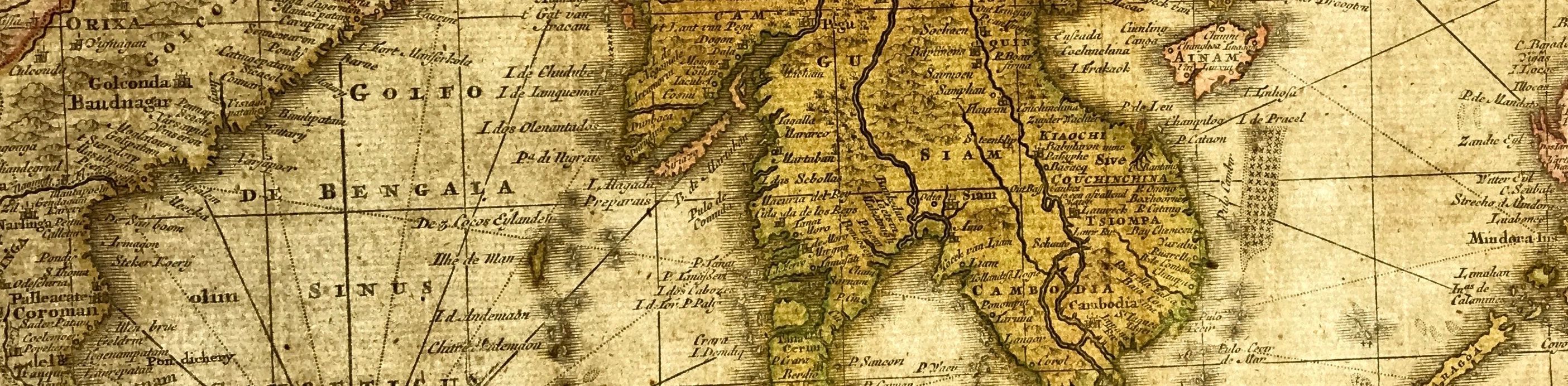 I would suggest a real help to you as a new collector of maps is to get an understanding of what the map was printed onto, yes, the paper! Getting an understanding of the history of paper making and how it relates to old maps is the real place to start. Have you heard the term 'laid paper' or seen it used by a dealer in describing a map. All maps were printed on laid paper up until around the end of the 18th century. This process involved a slurry being made from linen and cotton rags and each sheet of paper being made by hand. The slurry was spread over a handmade wire screen mold. 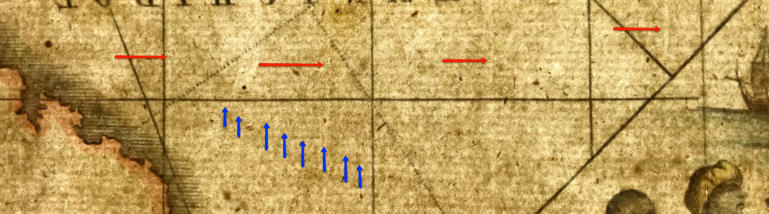 This laid paper has a very distinct appearance and is identified by the visible lines seen in the paper when held up to bright light. The vertical lines (Red arrows), normally about an inch apart, called chain lines are clearly distinguishable from the horizontal lines (Blue arrows) called laid lines. Hence laid paper. This is why its so important when possible to be able to examine an old map especially when you're new to map collecting and maybe not so familiar with knowing what to look for when it come to identifying and dating a map. So the place to start is with the paper. In the coming weeks I'll share more info on this subject, this is a start, it's not just what's on the paper, its the very paper itself thats all important. This is why I recommend the more you can go to auctions, see antique maps, touch them, feel the paper, examine it, hold the map up to the light. then you will start to see there is another world of exploration under the surface of the image - The all important paper! Have fun! The map and images above: Rare Map of Southeast Asia, Indian Ocean and Australia "India Orientalis cum Adjacentibus Insulis Nova Delineatione ob oculos posita . ." c1730/42 Matthaus Seutter. SEE THE MAP HERE
Click the link to continue to Part 2 in the Series Collecting Antique Maps
For those of you who go to auctions and love to have a rummage in the job lot boxes, this one is for you. I must be honest I always try to have a quick look at said job lots. When it come to decorative prints, sometimes old maps, you simply never know what you may come across. Often with not enough time to wade through a box with hundreds of items I'll take a risk. If I've spotted a few things of interest then I'll take a punt and place a calculated bid on the lot. It's a bit like a lucky dip, you never know what you might get especially tucked away at the bottom of the box.
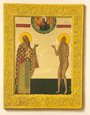
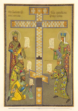
Recently on going through a pile of prints I'd set aside momentarily, which turned into a couple of years, I noticed what was tucked away at the bottom of the box! To my delight I discovered a small number of scarce Russian Art prints. Having taken the time to research the prints I discovered they're from “Antiquities of the Russian State.” Originally conceived by A.N. Olenin, President of the Academy of Arts, and undertaken with the patronage of Tsar Nicholas I. with descriptions written by Stroganov and illustrated by Fedor Solntsev. The work was published in a modest edition of 600 copies. Czar Nicholas I, emperor of all Russia from 1825 to 1855, in a sense had his own image consultant, the artist Fedor Solntsev. Nicholas commissioned Solntsev to make illustrations for what would become the work “Antiquities of the Russian State" Published 1825-55. The book started as a portable version of the vast riches housed in the Kremlin’s collection; it became a go-to manual on the Old Russian style, which reflected the country’s medieval past visually and also connoted the czar’s power over a huge and heterogeneous country. The large folio prints, loose as first issued are fine chromolithographs. You can now see the prints online as they are part of The New York Public Library's Digital Collection. See the link below: New York Public Library Digital Collection I have just a handful of these scarce prints available, thanks to the bottom of the box! You can see them here: Russian Art
A favourite of mine is the work of Alain Manesson Mallet a French cartographer and engineer. He started his career as a soldier in the army of Louis XIV, became a Sergeant-Major in the artillery and an Inspector of Fortifications. He also served under the King of Portugal, before returning to France, and his appointment to the court of Louis XIV.
 While the world has been busy in the battle against Coronavirus many of us have experienced long periods of lockdown. I've not attended an auction looking for antique maps and prints for months. I really hope to get back out and see people again soon. Recently though I've been attending more online auctions where I felt comfortable about making an 'absentee bid' based on info and pictures provided to me by the auction house.
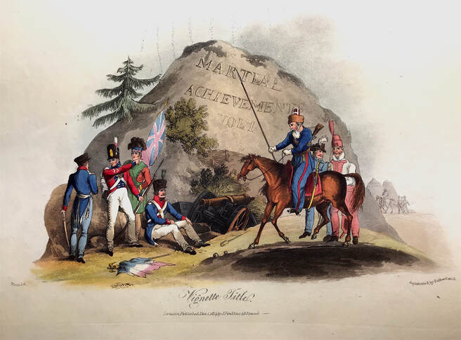
I'm delighted to report one of these acquisitions was for a rather sorry and broken copy of "The Martial Achievements of Great Britain and Her Allies; from 1799 to 1815" Printed for James Jenkins No 48 Strand By L. Harrison & J. C. Leigh, 373 Strand. To my delight, considering I'd not been able to go and actually look at the condition of the plates the majority remain in exceptional condition. The hand coloured plates are military scenes and battles, by T. Sutherland, D. Havell, M. Dubourg, J. Hill et al from drawings by William Heath. Heath (1794 - 1840) was a British artist. His early works often dealt with military themes, and this is probably the best known of his illustrated military books. In the coming weeks I will share more from this exceptional illustrated work and hope to make prints available for sale when ready. If you're aware of this work as a print collector and are after a particular print from this series please drop me an email......kevin@raremapsandprints.co.uk Stay Safe! |
LEARN ABOUT MAPS Where to Start? The Paper Earliest Maps Whats on the Paper? Rectum & Recto Marketing Devices Why Changing Faces? What is Ornamentation? Why all those lines? The Embellishment Story Illogical Prices Explained A Reference Library CLICK THE BOOK
Get the FREE Guide!
COLLECTING MAPS
Size Matters! Celestial Maps Strip Road Maps Sea Charts On the River of Life Projections The Sea Monsters Thematic Maps Town Plans Buy with Confidence. . .
More Top Tips for the Novice. Click the book to find out more . . .
COLLECTING PRINTS
Views of River Thames
Views of London Shipping & Craft Meet the Fairies Maritime Naval Military Battles Botanical Historic Churches Historic Views of Rome Archives
October 2023
|
kevin@raremapsandprints.co.uk
+44 7788 628706