RARE MAPS AND PRINTS
help@raremapsandprints.co.uk
+44 7788 628706
  • Start Here
  • About
  • Maps
    • British Isles
    • English Counties
    • Road Maps
    • River Thames
    • The Americas
    • Asia to Australia
    • Europe & Middle East
    • World & Hemispheres
    • Sea Charts
    • Military Battle Maps
  • Prints
    • British Topography >
      • Views River Thames
      • Views England
      • Views Wales
      • Views London
    • Satire & Caricature >
      • Vanity Fair Prints
      • Tour of Dr Syntax
      • William Hogarth
      • Max Beerbohm
    • Sporting
    • Amorial
    • Military & Naval
    • Portrait
    • Russian Art
    • Views Italy
  • Engravings
    • Copper
    • Steel
    • Etching
    • Wood Block
    • Lithograph
    • Lithotint
    • Aquatint
    • Photogravure
  • Resources
    • Reference Books
  • Blog
  • Contact
  • Antique Maps
  • >
  • River Thames
  • >
  • Taunt Map 25 Published 1885

Taunt Map 25 Published 1885

SKU:
£65.00
£50.00
£50.00
Unavailable
per item

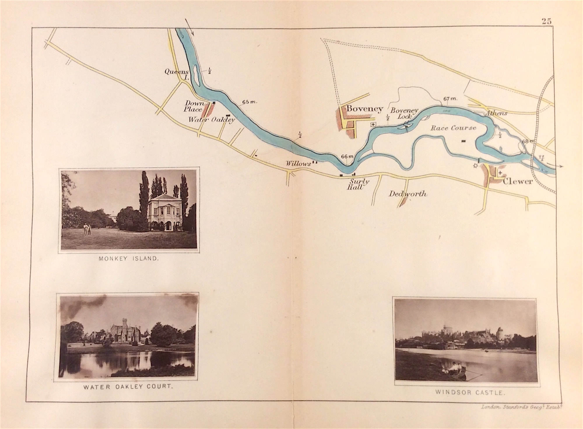
Original River Thames 'Map 25' by Henry W. Taunt c1885 Photographer to the Oxford Architectural and Historical Society from 'A New Map of The River Thames from Thames Head to London' on a scale of two inches to a mile. With original tipped in albumen prints that were added to the map before publication. A unique and exceptional smaller map of the river Thames.

Lithograph print with early albumen prints and additional later hand colour by Henry W. Taunt

In 'A New Map of The River Thames from Thames Head to London' c1885 Oxford Taunt & Co 9 & 10 Broad Street, London, Simpkin Marshall & Co, Stationers Hall Court

Original lithograph map in overall good condition, centre fold as issued. Finely detailed with later hand colouring and some age tone. 

Approx engraved area: 7" x 9" (180mm x 230mm)

Notes: An unusual small map of the stretch of the river Thames that runs from Queens Eyot just upstream of Oakley Court through Boveney and on to Clewer village near Windsor. The map is accompanied by three original albumen prints - Monkey Island - Water Oakley Court - Windsor Castle.

A genuine antique map over 130 years old.

  • Facebook
  • Twitter
  • Pinterest
  • Google+
Buy Now
Contact Info:     
Rare Maps and Prints Limited 
4, Ray House, Cressington Place,
​Bourne End, Bucks SL8 5SL UK 
                             
Kevin J Ryan :     

email: kevin@raremapsandprints.co.uk         
​
Customer Service     
email: help@raremapsandprints.co.uk           
Picture
Member of
​INTERNATIONAL MAP COLLECTORS SOCIETY 


    Maps & Prints Updates

Subscribe to List

Copyright © 2021  -  Rare Maps and Prints Limited  -  Raremapsandprints.co.uk   All Rights Reserved     Site Map     Terms & Conditions     Privacy Policy
  • Start Here
  • About
  • Maps
    • British Isles
    • English Counties
    • Road Maps
    • River Thames
    • The Americas
    • Asia to Australia
    • Europe & Middle East
    • World & Hemispheres
    • Sea Charts
    • Military Battle Maps
  • Prints
    • British Topography >
      • Views River Thames
      • Views England
      • Views Wales
      • Views London
    • Satire & Caricature >
      • Vanity Fair Prints
      • Tour of Dr Syntax
      • William Hogarth
      • Max Beerbohm
    • Sporting
    • Amorial
    • Military & Naval
    • Portrait
    • Russian Art
    • Views Italy
  • Engravings
    • Copper
    • Steel
    • Etching
    • Wood Block
    • Lithograph
    • Lithotint
    • Aquatint
    • Photogravure
  • Resources
    • Reference Books
  • Blog
  • Contact

    Join Our List

sign up
SHOP
Home
Shop
About
Updates
Contact
SOCIAL
Facebook
Twitter
Instagram
Proudly powered by Weebly