RARE MAPS AND PRINTS
[email protected]
+44 7788 628706
  • About
  • Maps
    • British Isles
    • English Counties
    • Road Maps
    • River Thames
    • The Americas
    • Asia to Australia
    • Europe & Middle East
    • World & Hemispheres
    • Sea Charts
    • Military Battle Maps
  • Prints
    • British Topography >
      • Views England & Scotland
      • Views Wales
      • Views London
      • Views River Thames
    • Sporting
    • Amorial
    • Military & Naval
    • Portrait
    • Russian Art
    • Views Italy
  • Resources
    • Reference Books
  • Blog
  • The Colourist
  • Antique Maps
  • >
  • Asia to Australia
  • >
  • Eastern Russia Published 1798

Eastern Russia Published 1798

SKU:
£285.00
£285.00
Unavailable
per item

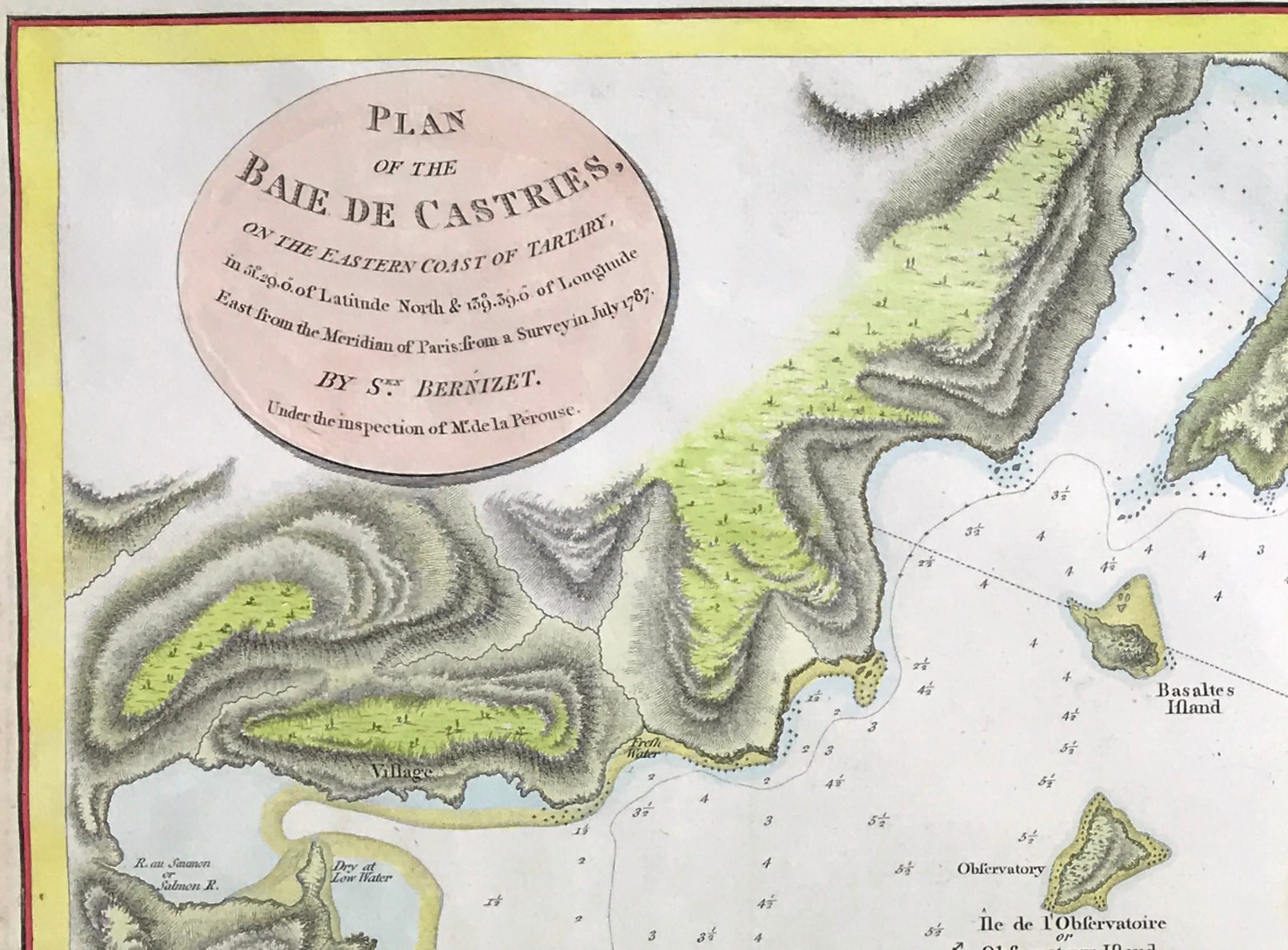
MAP of Eastern Russia Bay of De-Kastri c1798 PLAN OF THE BAIE DE CASTRIES ON THE EASTERN COAST OF TARTARY c1798 by Sebastian Berzinet. Copper engraved with hand colour. Sen Berzinet. Engraved by S. Neele sculpt. 352 Strand. Published by G.G. & J. Robinson, Paternoster Row, London Nov 1st 1798.

Good, age tone to center fold and edges, blank to verso, fold as issued, later hand colour. Prominent plate mark on laid paper.

Approx engraved area: 16.5" X 20" (405mm x 510mm)

Notes: Full Title: Plan de la Baie Castries. Situee sur la cote orientale de Tartarie, par 51029'0" de latitude nord et 139039'0" de longitude orientale du meridien de Paris, leve en juillet 1787. Par Sen. Bernizet sous l'inspection de M. de la Perouse. L. Aubert scripsit. Atlas du Voyage de la Perouse no. 52. (Paris: L'Imprimerie de la Republique, An V, 1797) Author: Bernizet, Sebastien; La Perouse, Jean-Francois de Galaup, comte de, 1741-1788

Located on the far eastern coast of Russia. The Bay of Castries, named in honor of Marshal Castries, was explored between 27 July and 2 August 1787, and today houses the port of De-Kastri. The expedition led by La Perouse left Brest in August 1785, doubled Cape Horn, went up the west coast of America to Alaska via Easter Island and Hawaii,then returned to California and crossed the Pacific, to Macao. She continued to Samoa, the Tonga Islands, then Australia and Botany Bay, from where La Perouse wrote the last letter that reached Europe. Subsequently, the two corvettes of the expedition were to disappear at sea. Their wrecks were only found in 1826 by the English captain Peter Dillon in the archipelago of Santa Cruz.

  • Facebook
  • Twitter
  • Pinterest
  • Google+
Buy Now
Contact Info:     
Rare Maps and Prints Limited 
4, Ray House, Cressington Place,
​Bourne End, Bucks SL8 5SL UK 
                             
Kevin J Ryan :     

email: [email protected]         
​
    
          
Picture
Member of
​INTERNATIONAL MAP COLLECTORS SOCIETY 


    Maps & Prints Updates

Subscribe to List

Copyright © 2025 -  Rare Maps and Prints Limited  -  Raremapsandprints.co.uk   All Rights Reserved     Site Map     Terms & Conditions     Privacy Policy
  • About
  • Maps
    • British Isles
    • English Counties
    • Road Maps
    • River Thames
    • The Americas
    • Asia to Australia
    • Europe & Middle East
    • World & Hemispheres
    • Sea Charts
    • Military Battle Maps
  • Prints
    • British Topography >
      • Views England & Scotland
      • Views Wales
      • Views London
      • Views River Thames
    • Sporting
    • Amorial
    • Military & Naval
    • Portrait
    • Russian Art
    • Views Italy
  • Resources
    • Reference Books
  • Blog
  • The Colourist

    Join Our List

sign up
SHOP
Home
Shop
About
Updates
Contact
SOCIAL
Facebook
Twitter
Instagram
Proudly powered by Weebly