RARE MAPS AND PRINTS
[email protected]
+44 7788 628706
  • About
  • Maps
    • British Isles
    • English Counties
    • Road Maps
    • River Thames
    • The Americas
    • Asia to Australia
    • Europe & Middle East
    • World & Hemispheres
    • Sea Charts
    • Military Battle Maps
  • Prints
    • British Topography >
      • Views England & Scotland
      • Views Wales
      • Views London
      • Views River Thames
    • Sporting
    • Amorial
    • Military & Naval
    • Portrait
    • Russian Art
    • Views Italy
  • Resources
    • Reference Books
  • Blog
  • The Colourist
  • Antique Maps
  • >
  • Road Maps
  • >
  • London to Carlisle Published 1766

London to Carlisle Published 1766

SKU:
£55.00
£55.00
Unavailable
per item

Antique Road Map by John Gibson c1766

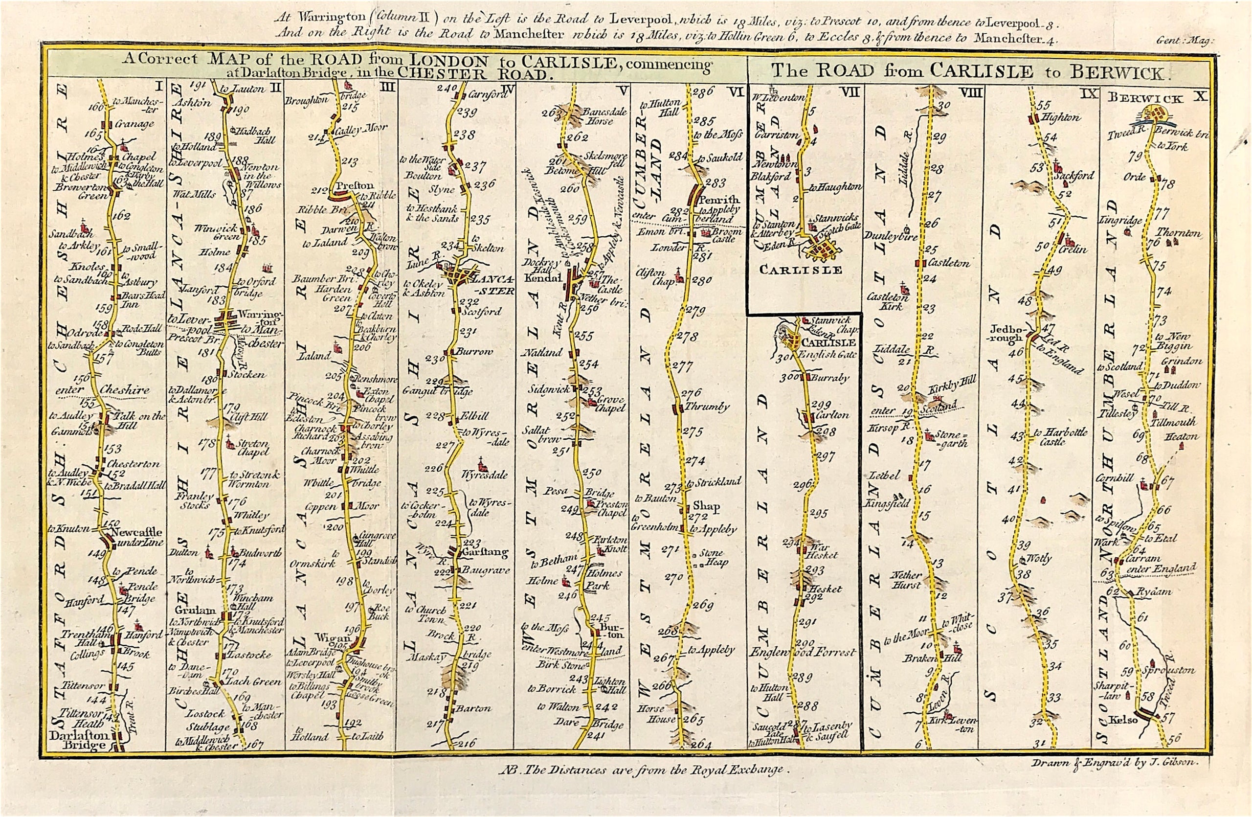
'A Correct MAP of the ROAD... to CARLISLE, commencing at Darlaston Bridge,' 'The ROAD from CARLISLE to BERWICK.' by J. Gibson / Gent. Mag c.1766

Method: Copper plate engraved

Creator: John Gibson

Published: c1766

Approx engraved area: 11.25" X 7.25" (287mm x 185mm)

Condition: Good Condition with later fine detailed outline and wash hand colour

Folds as issued, blank to verso, some general age tone.

Notes:Showing the route from Darlaston Bridge to Carlisle via Newcastle under Lyme, Warrington, Wigan, Preston, Lancaster, Kendal and Penrith; and then the route from Carlisle to Berwick via Jedburgh and Kelso which was drawn and engraved by J. Gibson and published in Sylvanus Urban's The Gentleman's Magazine (London: D. Henry, 1766).

  • Facebook
  • Twitter
  • Pinterest
  • Google+
Buy Now
Contact Info:     
Rare Maps and Prints Limited                        
Kevin J Ryan :     

email: [email protected]         
​
    
          
Picture
Member of
​INTERNATIONAL MAP COLLECTORS SOCIETY 


    Maps & Prints Updates

Subscribe to List

Copyright © 2025 -  Rare Maps and Prints Limited  -  Raremapsandprints.co.uk   All Rights Reserved     Site Map     Terms & Conditions     Privacy Policy
  • About
  • Maps
    • British Isles
    • English Counties
    • Road Maps
    • River Thames
    • The Americas
    • Asia to Australia
    • Europe & Middle East
    • World & Hemispheres
    • Sea Charts
    • Military Battle Maps
  • Prints
    • British Topography >
      • Views England & Scotland
      • Views Wales
      • Views London
      • Views River Thames
    • Sporting
    • Amorial
    • Military & Naval
    • Portrait
    • Russian Art
    • Views Italy
  • Resources
    • Reference Books
  • Blog
  • The Colourist

    Join Our List

sign up
SHOP
Home
Shop
About
Updates
Contact
SOCIAL
Facebook
Twitter
Instagram
Proudly powered by Weebly