RARE MAPS AND PRINTS
help@raremapsandprints.co.uk
+44 7788 628706
  • Start Here
  • About
  • Maps
    • British Isles
    • English Counties
    • Road Maps
    • River Thames
    • The Americas
    • Asia to Australia
    • Europe & Middle East
    • World & Hemispheres
    • Sea Charts
  • Prints
    • British Topography >
      • Views River Thames
      • Views England
      • Views Wales
      • Views London
    • Satire & Caricature >
      • Vanity Fair Prints
      • Tour of Dr Syntax
      • William Hogarth
      • Max Beerbohm
    • Sporting
    • Amorial
    • Military & Naval
    • Russian Art
    • Views Italy
  • Engravings
    • Copper
    • Steel
    • Etching
    • Wood Block
    • Lithograph
    • Lithotint
    • Aquatint
    • Photogravure
  • Resources
  • Blog
  • Contact
  • Antique Maps
  • >
  • British Isles
  • >
  • Great Britain Published c1863

Great Britain Published c1863

SKU:
£55.00
£55.00
Unavailable
per item

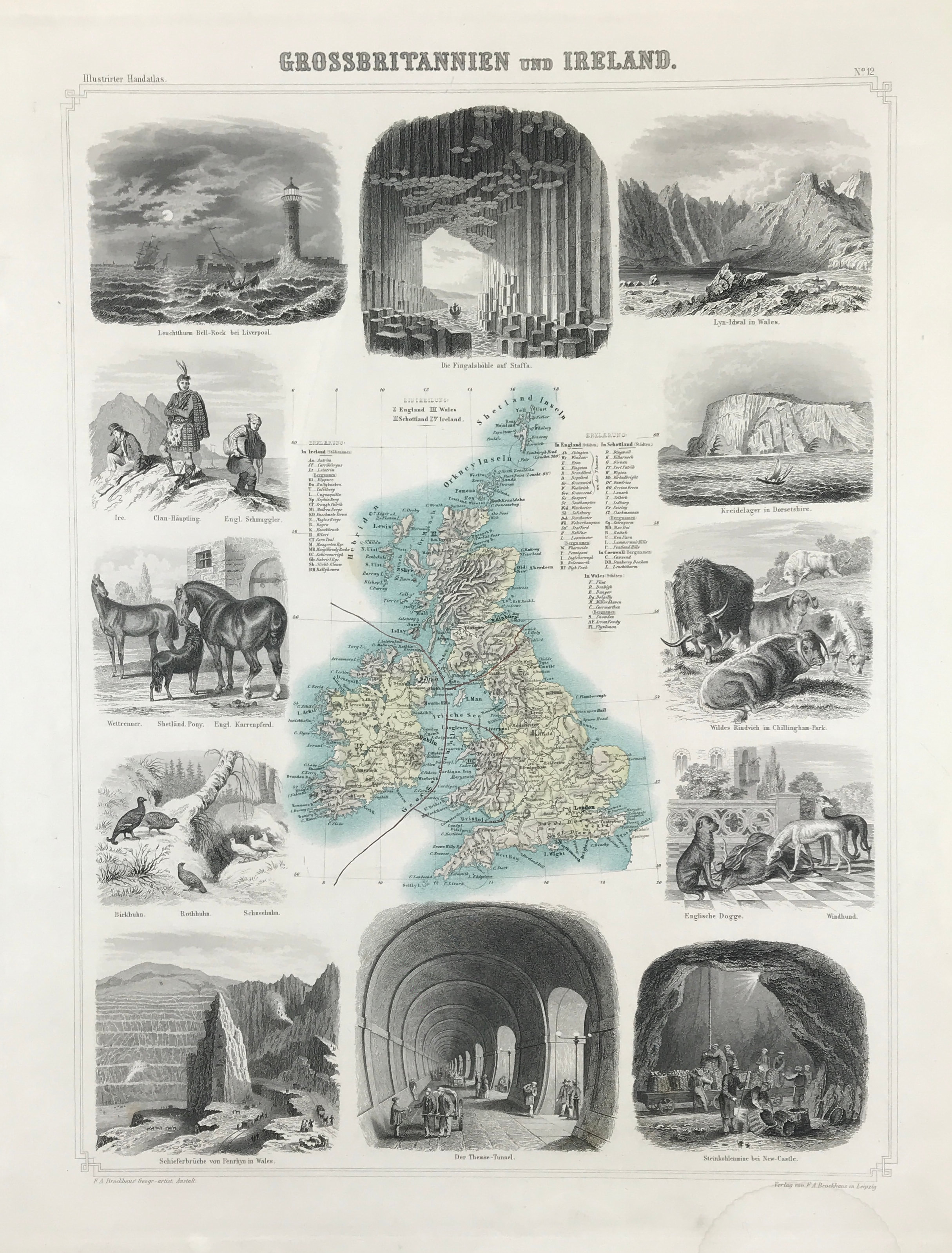
Antique Map of Great Britain & Ireland c1863 A map of the British Isles, surrounded by 12 hand coloured wood-engraved vignettes including Bell Rock Lighthouse near Liverpool, Coal Mine near Newcastle, English Dogs, Chillingham Park Cattle an English Smuggler, Slate Quarry at Penryn.


From Leeder (Ehrenfried) and Theodor Schade: Illustrirter Handatlas für Freunde der Erdkunde und zum Gebrauch beim unterricht. Im verein mit Heinrich Leutemann herausgegeben, Leipzig, F.A. Brockhaus. ( Illustrated hand atlas for friends of geography and for use in teaching.

Published in association with Heinrich Leutemann, Leipzig, F.A. Brockhaus. )

Engraved area approx: 17.5" x 13" (440mm x 330mm)

Good condition, some age tone, steel engraved with litho colour

A genuine antique map over 150 years old.

  • Facebook
  • Twitter
  • Pinterest
  • Google+
Buy Now
Contact Info:     
Rare Maps and Prints Limited 
4, Ray House, Cressington Place,
​Bourne End, Bucks SL8 5SL UK 
                             
Kevin J Ryan :     

email: kevin@raremapsandprints.co.uk         
​
Customer Service     
email: help@raremapsandprints.co.uk           
Picture
Member of
​INTERNATIONAL MAP COLLECTORS SOCIETY 


    Maps & Prints Updates

Subscribe to List

Copyright © 2021  -  Rare Maps and Prints Limited  -  Raremapsandprints.co.uk   All Rights Reserved     Site Map     Terms & Conditions     Privacy Policy
  • Start Here
  • About
  • Maps
    • British Isles
    • English Counties
    • Road Maps
    • River Thames
    • The Americas
    • Asia to Australia
    • Europe & Middle East
    • World & Hemispheres
    • Sea Charts
  • Prints
    • British Topography >
      • Views River Thames
      • Views England
      • Views Wales
      • Views London
    • Satire & Caricature >
      • Vanity Fair Prints
      • Tour of Dr Syntax
      • William Hogarth
      • Max Beerbohm
    • Sporting
    • Amorial
    • Military & Naval
    • Russian Art
    • Views Italy
  • Engravings
    • Copper
    • Steel
    • Etching
    • Wood Block
    • Lithograph
    • Lithotint
    • Aquatint
    • Photogravure
  • Resources
  • Blog
  • Contact

    Join Our List

sign up
SHOP
Home
Shop
About
Updates
Contact
SOCIAL
Facebook
Twitter
Instagram
Proudly powered by Weebly