RARE MAPS AND PRINTS
[email protected]
+44 7788 628706
  • About
  • Maps
    • British Isles
    • English Counties
    • Road Maps
    • River Thames
    • The Americas
    • Asia to Australia
    • Europe & Middle East
    • World & Hemispheres
    • Sea Charts
    • Military Battle Maps
  • Prints
    • British Topography >
      • Views England & Scotland
      • Views Wales
      • Views London
      • Views River Thames
    • Sporting
    • Amorial
    • Military & Naval
    • Portrait
    • Russian Art
    • Views Italy
  • Resources
    • Reference Books
  • Blog
  • The Colourist
  • Antique Maps
  • >
  • The Americas
  • >
  • Chart Columbus Voyages c1828 - SOLD!

Chart Columbus Voyages c1828 - SOLD!

SKU:
£0.00
Unavailable
per item

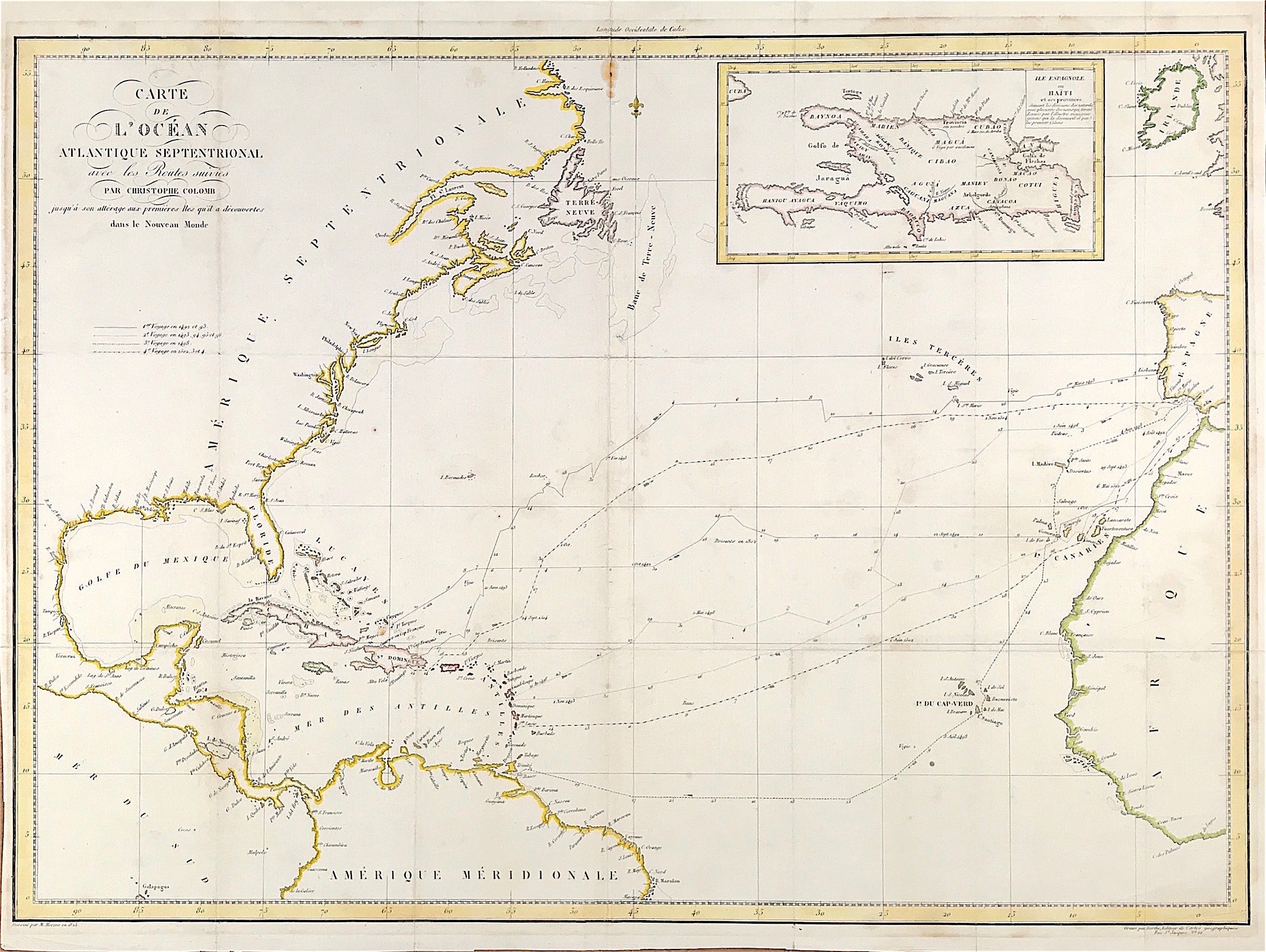
Large Map of the Caribbean islands c1828 - Carte de l'océan Atlantique septentrional avec les Routes suivies par Christophe Colomb jusqu'à son allérage aux premières Iles qu'ill a découvertes dans le Nouveau Monde. Published Paris 1828 Chez Treuttel et Würtz, rue de Bourbon, no 17; à Strasbourg et à Londres, même maison de commerce.

Author: Navarrete, Martín Fernández de, 1765-1844. Creator/Engraver: Berthe

Large Map of the Caribbean islands including the southern and eastern part of North America and the northern part of South America. Also shows the western part of Africa and Ireland. Includes an inset map of Hispaniola or present-day Haiti and Santo Domingo. Shows the routes taken by Christopher Columbus on his four voyages. Routes indicated with journey date markers - Year, Month, Day. Also Includes indication of shallows and dangerous rocks.

Original Copper plate engraved, good impression and plate mark, some old creasing around fold lines. Small stain to top of centre fold just inside boarder . Old strengthening to verso centre fold. General age tone. Fine later outline and wash colour.

Approx engraved area 19.75" x 23.75" (500mm x 600mm)

A genuine antique map over 190 years old

  • Facebook
  • Twitter
  • Pinterest
  • Google+
Buy Now
Contact Info:     
Rare Maps and Prints Limited 
4, Ray House, Cressington Place,
​Bourne End, Bucks SL8 5SL UK 
                             
Kevin J Ryan :     

email: [email protected]         
​
    
          
Picture
Member of
​INTERNATIONAL MAP COLLECTORS SOCIETY 


    Maps & Prints Updates

Subscribe to List

Copyright © 2025 -  Rare Maps and Prints Limited  -  Raremapsandprints.co.uk   All Rights Reserved     Site Map     Terms & Conditions     Privacy Policy
  • About
  • Maps
    • British Isles
    • English Counties
    • Road Maps
    • River Thames
    • The Americas
    • Asia to Australia
    • Europe & Middle East
    • World & Hemispheres
    • Sea Charts
    • Military Battle Maps
  • Prints
    • British Topography >
      • Views England & Scotland
      • Views Wales
      • Views London
      • Views River Thames
    • Sporting
    • Amorial
    • Military & Naval
    • Portrait
    • Russian Art
    • Views Italy
  • Resources
    • Reference Books
  • Blog
  • The Colourist

    Join Our List

sign up
SHOP
Home
Shop
About
Updates
Contact
SOCIAL
Facebook
Twitter
Instagram
Proudly powered by Weebly