RARE MAPS AND PRINTS
[email protected]
+44 7788 628706
  • About
  • Maps
    • British Isles
    • English Counties
    • Road Maps
    • River Thames
    • The Americas
    • Asia to Australia
    • Europe & Middle East
    • World & Hemispheres
    • Sea Charts
    • Military Battle Maps
  • Prints
    • British Topography >
      • Views England & Scotland
      • Views Wales
      • Views London
      • Views River Thames
    • Sporting
    • Amorial
    • Military & Naval
    • Portrait
    • Russian Art
    • Views Italy
  • Resources
    • Reference Books
  • Blog
  • The Colourist
  • Antique Maps
  • >
  • Asia to Australia
  • >
  • Pakistan & India 1752 SOLD!

Pakistan & India 1752 SOLD!

SKU:
£0.00
Unavailable
per item

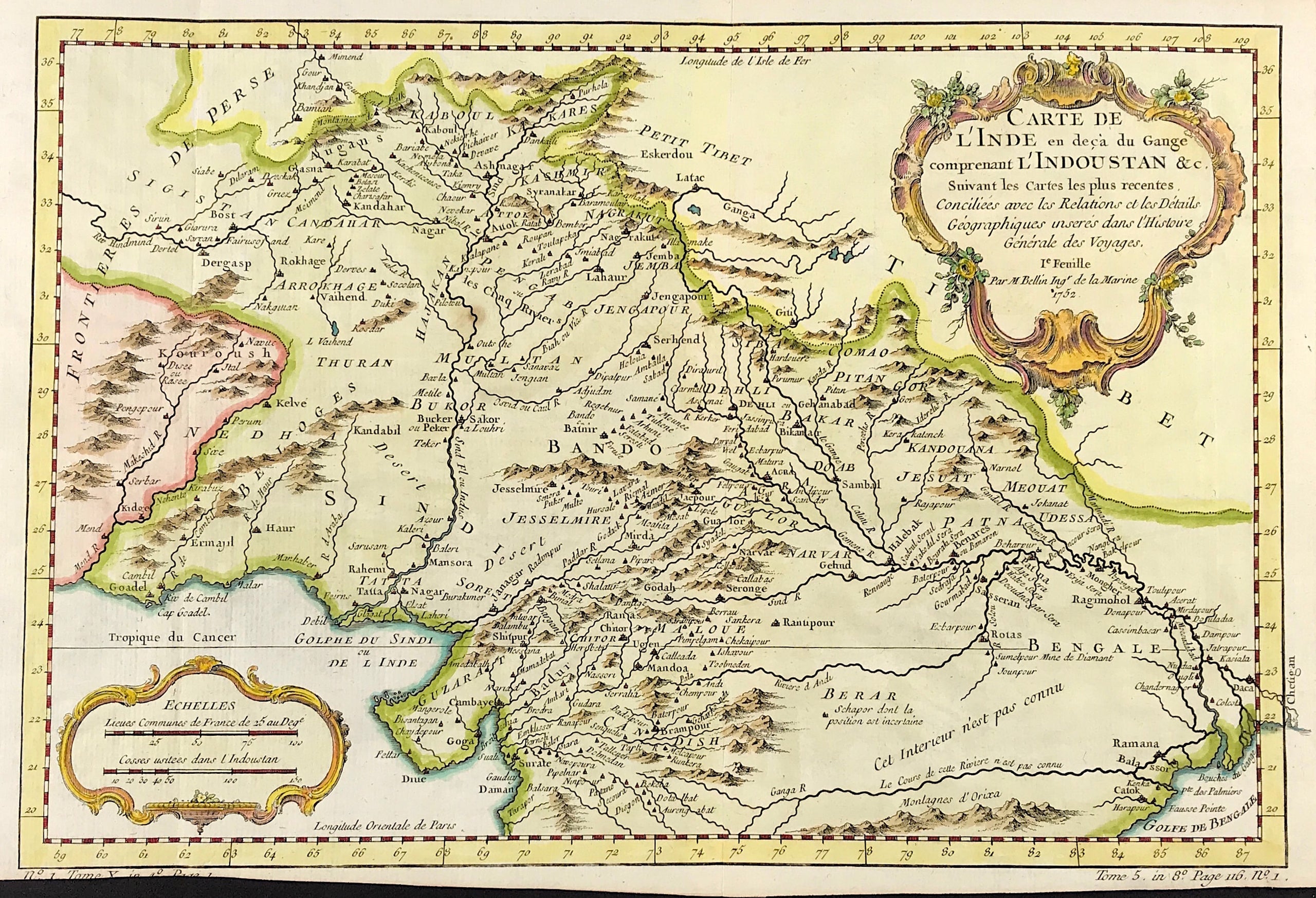
Map of PAKISTAN & NORTHERN INDIA Carte de l' Indoustan Ie Feuille c1752. By Nicolas Bellin

Good condition, fine detail, later wash & outline colour, blank to verso folds as issued.Some old crease and tone, approx engraved area 8.9" x 13.0' (225mm x 330mm) Close cut to lower boarder.

Interesting regional map of Afganistan, Pakistan, Tibet and and India. Extends from the Hindmind River in the west to the mouth of the Ganges and the Bay of Bengal in the east. Extends north to the Kaboul and Kashmir regions. A wonderfully detailed map. Includes a large decorative title cartouche. One of the maps produced by Nichlas Bellin for Prevost d'Exiles influential travel book, L'Histoire Generale des Voyages

Jaques Nicolas Bellin (1702-720) was the most important French hydrographer of the 18th century. Sea-atlas 'Hydrographique Français', 1756-65, an atlas to accompany Prévost d' Exile's 'Histoire. des Voyages', 1738-75.)

A genuine antique map over 260 years old

  • Facebook
  • Twitter
  • Pinterest
  • Google+
Buy Now
Contact Info:     
Rare Maps and Prints Limited 
4, Ray House, Cressington Place,
​Bourne End, Bucks SL8 5SL UK 
                             
Kevin J Ryan :     

email: [email protected]         
​
    
          
Picture
Member of
​INTERNATIONAL MAP COLLECTORS SOCIETY 


    Maps & Prints Updates

Subscribe to List

Copyright © 2025 -  Rare Maps and Prints Limited  -  Raremapsandprints.co.uk   All Rights Reserved     Site Map     Terms & Conditions     Privacy Policy
  • About
  • Maps
    • British Isles
    • English Counties
    • Road Maps
    • River Thames
    • The Americas
    • Asia to Australia
    • Europe & Middle East
    • World & Hemispheres
    • Sea Charts
    • Military Battle Maps
  • Prints
    • British Topography >
      • Views England & Scotland
      • Views Wales
      • Views London
      • Views River Thames
    • Sporting
    • Amorial
    • Military & Naval
    • Portrait
    • Russian Art
    • Views Italy
  • Resources
    • Reference Books
  • Blog
  • The Colourist

    Join Our List

sign up
SHOP
Home
Shop
About
Updates
Contact
SOCIAL
Facebook
Twitter
Instagram
Proudly powered by Weebly