RARE MAPS AND PRINTS
[email protected]
+44 7788 628706
  • About
  • Maps
    • British Isles
    • English Counties
    • Road Maps
    • River Thames
    • The Americas
    • Asia to Australia
    • Europe & Middle East
    • World & Hemispheres
    • Sea Charts
    • Military Battle Maps
  • Prints
    • British Topography >
      • Views England & Scotland
      • Views Wales
      • Views London
      • Views River Thames
    • Sporting
    • Amorial
    • Military & Naval
    • Portrait
    • Russian Art
    • Views Italy
  • Resources
    • Reference Books
  • Blog
  • The Colourist
  • Antique Maps
  • >
  • The Americas
  • >
  • North America c1784- SOLD!

North America c1784- SOLD!

SKU:
£0.00
Unavailable
per item

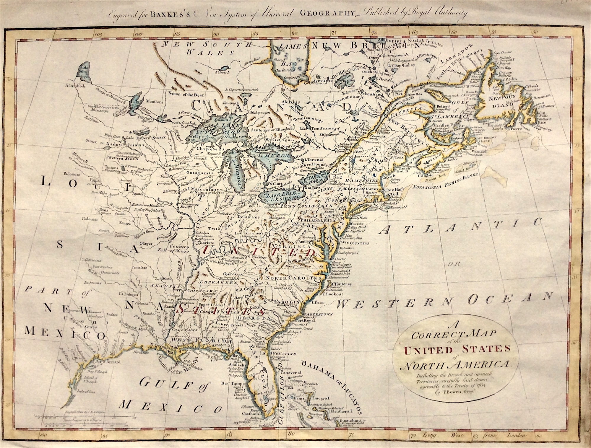
Antique Map 1784 "A Correct Map of the United States of North America" by Thomas Bowen.United States of North America. Including the British and Spanish Territories, carefully laid down agreeable to the Treaty of 1784. Early map of the United States, coloured by regions and Colonies. The map was published shortly after independence and prior to the admission of Kentucky, Tennessee or Vermont as states, although Vermont is named quite curiously appearing above "Hampshire." Both East and West Florida are shown. Many Indian tribes shown.

Engraved for Bankes's New system of universal geography, published by royal authority.

General good condition, double watermarked hand laid paper 1796. Some old light creasing and stain to lower right edge of sheet. Engraved area approx: Dimensions: 17.5” x 12”.

A genuine antique map over 220 years old

  • Facebook
  • Twitter
  • Pinterest
  • Google+
Buy Now
Contact Info:     
Rare Maps and Prints Limited 
4, Ray House, Cressington Place,
​Bourne End, Bucks SL8 5SL UK 
                             
Kevin J Ryan :     

email: [email protected]         
​
    
          
Picture
Member of
​INTERNATIONAL MAP COLLECTORS SOCIETY 


    Maps & Prints Updates

Subscribe to List

Copyright © 2025 -  Rare Maps and Prints Limited  -  Raremapsandprints.co.uk   All Rights Reserved     Site Map     Terms & Conditions     Privacy Policy
  • About
  • Maps
    • British Isles
    • English Counties
    • Road Maps
    • River Thames
    • The Americas
    • Asia to Australia
    • Europe & Middle East
    • World & Hemispheres
    • Sea Charts
    • Military Battle Maps
  • Prints
    • British Topography >
      • Views England & Scotland
      • Views Wales
      • Views London
      • Views River Thames
    • Sporting
    • Amorial
    • Military & Naval
    • Portrait
    • Russian Art
    • Views Italy
  • Resources
    • Reference Books
  • Blog
  • The Colourist

    Join Our List

sign up
SHOP
Home
Shop
About
Updates
Contact
SOCIAL
Facebook
Twitter
Instagram
Proudly powered by Weebly