RARE MAPS AND PRINTS
help@raremapsandprints.co.uk
+44 7788 628706
  • Start Here
  • About
  • Maps
    • British Isles
    • English Counties
    • Road Maps
    • River Thames
    • The Americas
    • Asia to Australia
    • Europe & Middle East
    • World & Hemispheres
    • Sea Charts
    • Military Battle Maps
  • Prints
    • British Topography >
      • Views River Thames
      • Views England
      • Views Wales
      • Views London
    • Satire & Caricature >
      • Vanity Fair Prints
      • Tour of Dr Syntax
      • William Hogarth
      • Max Beerbohm
    • Sporting
    • Amorial
    • Military & Naval
    • Portrait
    • Russian Art
    • Views Italy
  • Engravings
    • Copper
    • Steel
    • Etching
    • Wood Block
    • Lithograph
    • Lithotint
    • Aquatint
    • Photogravure
  • Resources
    • Reference Books
  • Blog
  • Contact
  • Decorative Prints
  • >
  • Military & Naval
  • >
  • The Battle of Toulouse c1814 - SOLD!

The Battle of Toulouse c1814 - SOLD!

SKU:
£0.00
Unavailable
per item

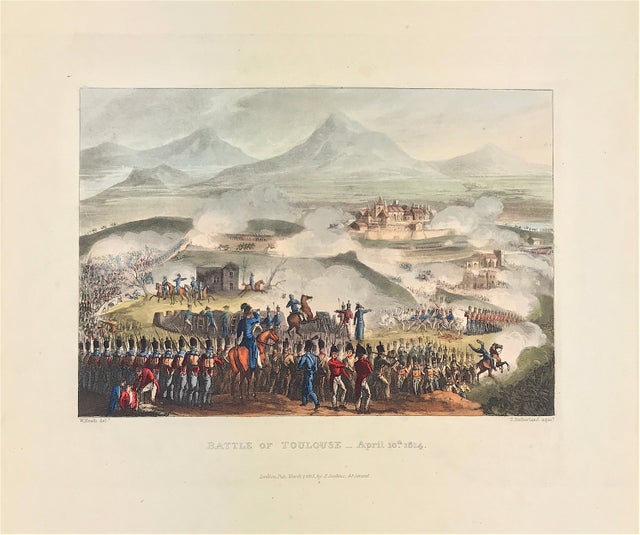
Napoleonic War: The Battle of Toulouse, on the 10th April 1814. London Published Mar 1st 1815 by J. Jenkins, 48 Strand. An original aquatint print from "The Martial achievements of Great Britain and Her Allies from 1799 to 1815. London: Printed for James Jenkins, No 48, Strand, By L. Harrison & J. C. Leigh, 373 Strand. 

Original aquatint engraving on medium weight wove paper with fine hand colour. Drawing by William Heath (delt) with aquatint engraving by Thomas Sutherland (sculpt). 

Good overall condition with exceptional original colour and wide margins. The plate has the date of publication and the name of the publisher beneath the engraved title. The approx engraved area of the plate is 8.5" x 7.75" (215mm x 195mm) including the engraved title text. Engraved plate mark area is approx 8.5 x 11.75 (215mm x 300mm). The large sheet size is approx 11.5" x 14" (290mm x 355mm).

The Battle of Toulouse (10 April 1814) was one of the final battles of the Napoleonic Wars, four days after Napoleon's surrender of the French Empire to the nations of the Sixth Coalition. Having pushed the demoralised and disintegrating French Imperial armies out of Spain in a difficult campaign the previous autumn, the Allied British-Portuguese and Spanish army under the Duke of Wellington pursued the war into southern France in the spring of 1814.

A genuine antique print over 200 years old.

  • Facebook
  • Twitter
  • Pinterest
  • Google+
Buy Now
Contact Info:     
Rare Maps and Prints Limited 
4, Ray House, Cressington Place,
​Bourne End, Bucks SL8 5SL UK 
                             
Kevin J Ryan :     

email: kevin@raremapsandprints.co.uk         
​
Customer Service     
email: help@raremapsandprints.co.uk           
Picture
Member of
​INTERNATIONAL MAP COLLECTORS SOCIETY 


    Maps & Prints Updates

Subscribe to List

Copyright © 2021  -  Rare Maps and Prints Limited  -  Raremapsandprints.co.uk   All Rights Reserved     Site Map     Terms & Conditions     Privacy Policy
  • Start Here
  • About
  • Maps
    • British Isles
    • English Counties
    • Road Maps
    • River Thames
    • The Americas
    • Asia to Australia
    • Europe & Middle East
    • World & Hemispheres
    • Sea Charts
    • Military Battle Maps
  • Prints
    • British Topography >
      • Views River Thames
      • Views England
      • Views Wales
      • Views London
    • Satire & Caricature >
      • Vanity Fair Prints
      • Tour of Dr Syntax
      • William Hogarth
      • Max Beerbohm
    • Sporting
    • Amorial
    • Military & Naval
    • Portrait
    • Russian Art
    • Views Italy
  • Engravings
    • Copper
    • Steel
    • Etching
    • Wood Block
    • Lithograph
    • Lithotint
    • Aquatint
    • Photogravure
  • Resources
    • Reference Books
  • Blog
  • Contact

    Join Our List

sign up
SHOP
Home
Shop
About
Updates
Contact
SOCIAL
Facebook
Twitter
Instagram
Proudly powered by Weebly