RARE MAPS AND PRINTS
help@raremapsandprints.co.uk
+44 7788 628706
  • Start Here
  • About
  • Maps
    • British Isles
    • English Counties
    • Road Maps
    • River Thames
    • The Americas
    • Asia to Australia
    • Europe & Middle East
    • World & Hemispheres
    • Sea Charts
    • Military Battle Maps
  • Prints
    • British Topography >
      • Views River Thames
      • Views England
      • Views Wales
      • Views London
    • Satire & Caricature >
      • Vanity Fair Prints
      • Tour of Dr Syntax
      • William Hogarth
      • Max Beerbohm
    • Sporting
    • Amorial
    • Military & Naval
    • Portrait
    • Russian Art
    • Views Italy
  • Engravings
    • Copper
    • Steel
    • Etching
    • Wood Block
    • Lithograph
    • Lithotint
    • Aquatint
    • Photogravure
  • Resources
    • Reference Books
  • Blog
  • Contact
  • Antique Maps
  • >
  • Reverence Books
  • >
  • Arabia in Early Maps

Arabia in Early Maps

SKU:
£95.00
£95.00
Unavailable
per item

Arabia in Early Maps by Tibbetts, G R.

Publisher: Falcon Oleander, Cambridge, 1978. Size: 10" x 8.5" (255mm x 215mm). Hardcover. Condition: Fine. Dust Jacket Condition: Fine.

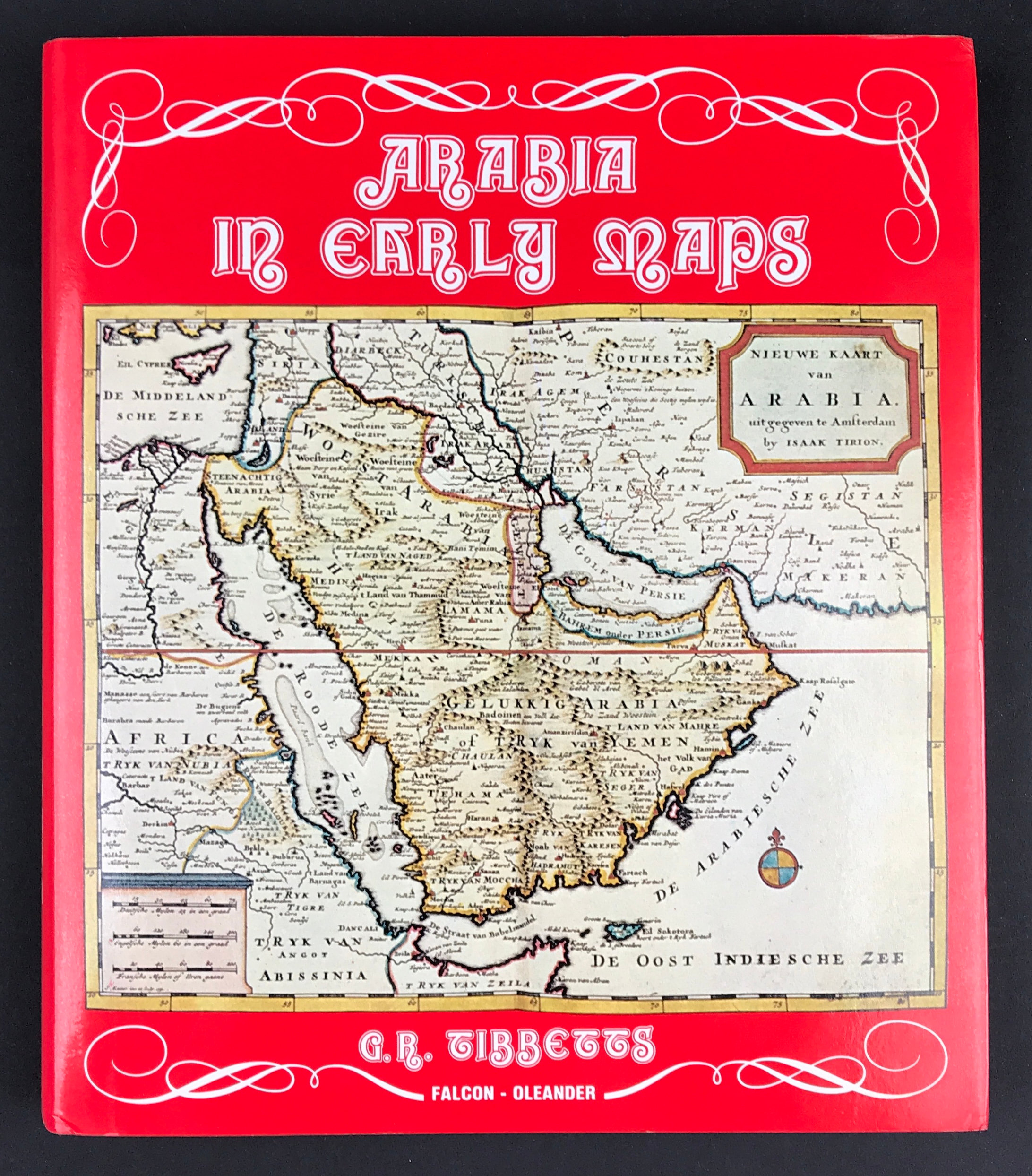
A bibliography of maps covering the Peninsula of Arabia printed in western Europe from the invention of printing to the year 1751. 175 pp, profuse ill, including many in colour. A complete, comprehensive list covering as much topographical detail of the peninsula as possible.

This book is an illustrated chronologlcal description of maps compiled and printed by western Cartographers before the time when European travellers began penetrate the Peninsula and when, because of the lack of surveys and first hand scientific accounts, material was taken at second hand from miscelaneous sources. This material often occurred as separate maps but was usually hidden in atlases or works of travel where it was difficult to locate and there have hitherto been no adequate bibliographical resources to help in locating it.

Arabia in Early Maps begins with the invention of printing and the production of maps to illustrate Ptolemy's Geography and ends in 1751 with D'Anville's famous map of Asia. it was the production of D'Anville's map which emphasised to the West its ignorance of inland Arabia and led ultimately to the first Scientific expedition to Arabia (that of Niebuhr in 1761-4)and the opening of European interest in the Peninsula.

  • Facebook
  • Twitter
  • Pinterest
  • Google+
Buy Now
Contact Info:     
Rare Maps and Prints Limited 
4, Ray House, Cressington Place,
​Bourne End, Bucks SL8 5SL UK 
                             
Kevin J Ryan :     

email: kevin@raremapsandprints.co.uk         
​
Customer Service     
email: help@raremapsandprints.co.uk           
Picture
Member of
​INTERNATIONAL MAP COLLECTORS SOCIETY 


    Maps & Prints Updates

Subscribe to List

Copyright © 2021  -  Rare Maps and Prints Limited  -  Raremapsandprints.co.uk   All Rights Reserved     Site Map     Terms & Conditions     Privacy Policy
  • Start Here
  • About
  • Maps
    • British Isles
    • English Counties
    • Road Maps
    • River Thames
    • The Americas
    • Asia to Australia
    • Europe & Middle East
    • World & Hemispheres
    • Sea Charts
    • Military Battle Maps
  • Prints
    • British Topography >
      • Views River Thames
      • Views England
      • Views Wales
      • Views London
    • Satire & Caricature >
      • Vanity Fair Prints
      • Tour of Dr Syntax
      • William Hogarth
      • Max Beerbohm
    • Sporting
    • Amorial
    • Military & Naval
    • Portrait
    • Russian Art
    • Views Italy
  • Engravings
    • Copper
    • Steel
    • Etching
    • Wood Block
    • Lithograph
    • Lithotint
    • Aquatint
    • Photogravure
  • Resources
    • Reference Books
  • Blog
  • Contact

    Join Our List

sign up
SHOP
Home
Shop
About
Updates
Contact
SOCIAL
Facebook
Twitter
Instagram
Proudly powered by Weebly