RARE MAPS AND PRINTS
[email protected]
+44 7788 628706
  • About
  • Maps
    • British Isles
    • English Counties
    • Road Maps
    • River Thames
    • The Americas
    • Asia to Australia
    • Europe & Middle East
    • World & Hemispheres
    • Sea Charts
    • Military Battle Maps
  • Prints
    • British Topography >
      • Views England & Scotland
      • Views Wales
      • Views London
      • Views River Thames
    • Sporting
    • Amorial
    • Military & Naval
    • Portrait
    • Russian Art
    • Views Italy
  • Resources
    • Reference Books
  • Blog
  • The Colourist
  • Antique Maps
  • >
  • English Counties
  • >
  • Oxfordshire Published 1838

Oxfordshire Published 1838

SKU:
£125.00
£95.00
£95.00
Unavailable
per item

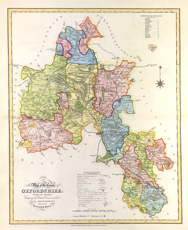
Map of OXFORDSHIRE from A Complete County Atlas of England & Wales. Published by JAMES DUNCAN c1838 A finely engraved and detailed map showing the changes made by the Great Reform Act of 1832.

Steel Engraved. Originally constructed by William Ebden, engraved by Hoare & Reeves Originally constructed by William Ebden, engraved by Hoare & Reeves and first published in Atlas form by James Duncan in 1833 James Duncan, Paternoster Row

Good Condition, slight offsetting and see through, outline and wash hand colour, fold as issued, blank to verso, some age tone.

Approx Engraved area: Large Sheet size: 15.5" X 19" (396mm x 483mm)

Notes: The Atlas provided Forty Four Superior Maps, Divided into Hundreds, With District Divisions and Other Local Arrangements effected by the Reform Bill. Ebden's impressive county maps are typical of the best produced for English atlases in the early 19th century. They are beautifully engraved and there relatively large size compared to most other county maps of the period ensures unusually clear depiction of a wide range of feature. Map highlights the counties individual hundreds and all major roads. There is a useful table of reference to the hundreds, an extensive explanation of the map symbols and a mileage scale.

  • Facebook
  • Twitter
  • Pinterest
  • Google+
Buy Now
Contact Info:     
Rare Maps and Prints Limited 
4, Ray House, Cressington Place,
​Bourne End, Bucks SL8 5SL UK 
                             
Kevin J Ryan :     

email: [email protected]         
​
    
          
Picture
Member of
​INTERNATIONAL MAP COLLECTORS SOCIETY 


    Maps & Prints Updates

Subscribe to List

Copyright © 2025 -  Rare Maps and Prints Limited  -  Raremapsandprints.co.uk   All Rights Reserved     Site Map     Terms & Conditions     Privacy Policy
  • About
  • Maps
    • British Isles
    • English Counties
    • Road Maps
    • River Thames
    • The Americas
    • Asia to Australia
    • Europe & Middle East
    • World & Hemispheres
    • Sea Charts
    • Military Battle Maps
  • Prints
    • British Topography >
      • Views England & Scotland
      • Views Wales
      • Views London
      • Views River Thames
    • Sporting
    • Amorial
    • Military & Naval
    • Portrait
    • Russian Art
    • Views Italy
  • Resources
    • Reference Books
  • Blog
  • The Colourist

    Join Our List

sign up
SHOP
Home
Shop
About
Updates
Contact
SOCIAL
Facebook
Twitter
Instagram
Proudly powered by Weebly