RARE MAPS AND PRINTS
[email protected]
+44 7788 628706
  • About
  • Maps
    • British Isles
    • English Counties
    • Road Maps
    • River Thames
    • The Americas
    • Asia to Australia
    • Europe & Middle East
    • World & Hemispheres
    • Sea Charts
    • Military Battle Maps
  • Prints
    • British Topography >
      • Views England & Scotland
      • Views Wales
      • Views London
      • Views River Thames
    • Sporting
    • Amorial
    • Military & Naval
    • Portrait
    • Russian Art
    • Views Italy
  • Resources
    • Reference Books
  • Blog
  • The Colourist
  • Antique Maps
  • >
  • English Counties
  • >
  • Middlesex Published 1750 SOLD

Middlesex Published 1750 SOLD

SKU:
£0.00
Unavailable
per item

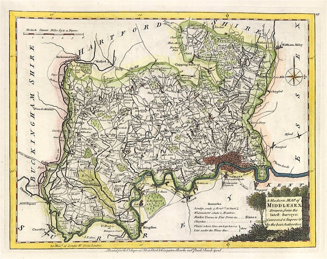
Original antique map of Middlesex By Joseph Ellis c1765. A Modern Map of Middlesex Drawn from the latest Surveys Corrected & Improved by the best Authorities.

Artist: Joseph Ellis & Engraver W Fowler for Ellis's English Atlas. Published by Carrington Bowles in St Pauls Church Yard & Robert Sayer in Fleet Street.

Borough towns are shown with stars identifying the number of members returned to parliament and "Places where Fairs are kept have a Line under the Name thus". Ellis (d.1796) was a prolific English engraver of the late eighteenth century who joined with William Palmer to produce a set of English county maps, published in Ellis' "New English Atlas", in 1765. Ellis' atlases were very popular, being often reprinted, as the maps are clearly and distinctively engraved with decorative title cartouches.

Excellent clean condition with Later Hand Colour. Blank to verso on heavy hand laid paper. Copy of Monmouthshire map on verso - Uncoloured. Approx Engraved Plate: 8" x 10.25" (200mm X 255mm)

  • Facebook
  • Twitter
  • Pinterest
  • Google+
Buy Now
Contact Info:     
Rare Maps and Prints Limited 
4, Ray House, Cressington Place,
​Bourne End, Bucks SL8 5SL UK 
                             
Kevin J Ryan :     

email: [email protected]         
​
    
          
Picture
Member of
​INTERNATIONAL MAP COLLECTORS SOCIETY 


    Maps & Prints Updates

Subscribe to List

Copyright © 2025 -  Rare Maps and Prints Limited  -  Raremapsandprints.co.uk   All Rights Reserved     Site Map     Terms & Conditions     Privacy Policy
  • About
  • Maps
    • British Isles
    • English Counties
    • Road Maps
    • River Thames
    • The Americas
    • Asia to Australia
    • Europe & Middle East
    • World & Hemispheres
    • Sea Charts
    • Military Battle Maps
  • Prints
    • British Topography >
      • Views England & Scotland
      • Views Wales
      • Views London
      • Views River Thames
    • Sporting
    • Amorial
    • Military & Naval
    • Portrait
    • Russian Art
    • Views Italy
  • Resources
    • Reference Books
  • Blog
  • The Colourist

    Join Our List

sign up
SHOP
Home
Shop
About
Updates
Contact
SOCIAL
Facebook
Twitter
Instagram
Proudly powered by Weebly