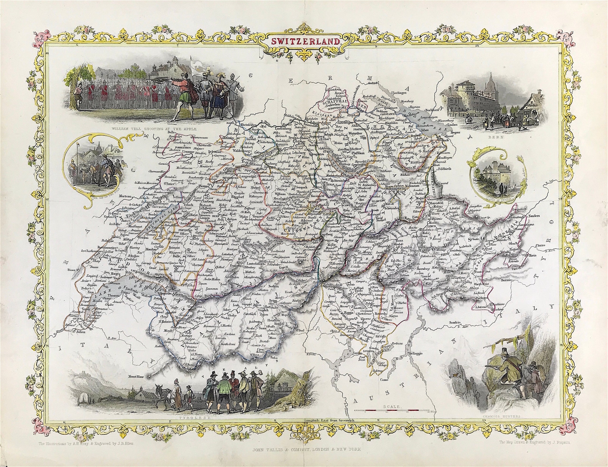
RARE MAPS AND PRINTS
help@raremapsandprints.co.uk
+44 7788 628706
  • Start Here
  • About
  • Maps
    • British Isles
    • English Counties
    • Road Maps
    • River Thames
    • The Americas
    • Asia to Australia
    • Europe & Middle East
    • World & Hemispheres
    • Sea Charts
  • Prints
    • British Topography >
      • Views River Thames
      • Views England
      • Views Wales
      • Views London
    • Satire & Caricature >
      • Vanity Fair Prints
      • Tour of Dr Syntax
      • William Hogarth
      • Max Beerbohm
    • Sporting
    • Amorial
    • Military & Naval
    • Russian Art
    • Views Italy
  • Engravings
    • Copper
    • Steel
    • Etching
    • Wood Block
    • Lithograph
    • Lithotint
    • Aquatint
    • Photogravure
  • Resources
  • Blog
  • Contact
  • xmas sale
  • Antique Maps
  • >
  • Europe Middle East
  • >
  • Switzerland Published 1851

Switzerland Published 1851

SKU:
£80.00
£80.00
Unavailable
per item

ANTIQUE MAP OF SWITZERLAND by John Tallis c1851 Although he only issued one world atlas, John Tallis is among the best known of all map-makers and publishers.The maps were issued in 1851 to commemorate the Great Exhibition in London and are considered the last series of decorative maps of the world, drawn and engraved by John Rapkin, combining fine cartographical detail within an elaborate and attractive border.

Steel engraved with later hand colour. Drawn and engraved by J. Rapkin. Approx engraved area: 12.5" x 10" (320mm x 250mm)

Good condition, hand colour, some age tone and stain to sheet boarders. Blank to verso and fold as issued. Surrounded by a decorative border.

Notes: John Tallis (1838-51) founder of Tallis and Co., London map publishers who traded under various names: L. Tallis, Tallis & co, John Tallis, John Tallis & co. (London &New York) between 1838 and 1851. After 1850-51, their maps were published by the London Printing and Publishing Co., London and NewYork. The Illustrated Atlas of the World, published in 1849 with the maps and decorative vignette?s engraved and drawn by J. Rapkin, was one of the last atlases to be truly decorated and is therefore highly prized.

  • Facebook
  • Twitter
  • Pinterest
  • Google+
Buy Now
Contact Info:     
Rare Maps and Prints Limited 
4, Ray House, Cressington Place,
​Bourne End, Bucks SL8 5SL UK 
                             
Kevin J Ryan :     

email: kevin@raremapsandprints.co.uk         
​
Customer Service     
email: help@raremapsandprints.co.uk           
Picture
Member of
​INTERNATIONAL MAP COLLECTORS SOCIETY 


    Maps & Prints Updates

Subscribe to List

Copyright © 2021  -  Rare Maps and Prints Limited  -  Raremapsandprints.co.uk   All Rights Reserved     Site Map     Terms & Conditions     Privacy Policy
  • Start Here
  • About
  • Maps
    • British Isles
    • English Counties
    • Road Maps
    • River Thames
    • The Americas
    • Asia to Australia
    • Europe & Middle East
    • World & Hemispheres
    • Sea Charts
  • Prints
    • British Topography >
      • Views River Thames
      • Views England
      • Views Wales
      • Views London
    • Satire & Caricature >
      • Vanity Fair Prints
      • Tour of Dr Syntax
      • William Hogarth
      • Max Beerbohm
    • Sporting
    • Amorial
    • Military & Naval
    • Russian Art
    • Views Italy
  • Engravings
    • Copper
    • Steel
    • Etching
    • Wood Block
    • Lithograph
    • Lithotint
    • Aquatint
    • Photogravure
  • Resources
  • Blog
  • Contact
  • xmas sale

    Join Our List

sign up
SHOP
Home
Shop
About
Updates
Contact
SOCIAL
Facebook
Twitter
Instagram
Proudly powered by Weebly