- Published on
I've just had the pleasure of reading 'Introduction to Pictorial Maps' by Matthias Mayenschein. If pictorial maps are of interest to you or a passion as they are for me then you must grab a copy of this work. I've put a link at the bottom of this article.
The book is a fascinating read. Presenting various maps and mapmakers all in chronological order from Claudius Ptolemy's "Geographia" up to the period of the 1960's then exploring the monumental and pictographic maps. The most striking maps are presented along with good historic background information. Many maps are illustrated, needless to say I can only give you a taste here. Hopefully this will be enough to stimulate your interest and you an go get a copy for yourself and yes the book is currently available FREE!
The book is a fascinating read. Presenting various maps and mapmakers all in chronological order from Claudius Ptolemy's "Geographia" up to the period of the 1960's then exploring the monumental and pictographic maps. The most striking maps are presented along with good historic background information. Many maps are illustrated, needless to say I can only give you a taste here. Hopefully this will be enough to stimulate your interest and you an go get a copy for yourself and yes the book is currently available FREE!
The subjects covered and some examples:
1) Pictorial Maps - What are they?
2) The history of pictorial maps, early beginnings with description of the most striking examples
1) Pictorial Maps - What are they?
2) The history of pictorial maps, early beginnings with description of the most striking examples
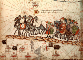
Pictorial maps were drawn since prehistoric times. Some of the wall paintings show maps of hunting areas, streams, routes, and even maps of the stars. Let’s begin this introduction to pictorial maps with the Catalan Atlas from 1375. It is one of the earliest medieval charts, used by marine navigators, containing geographic data from the Hebrew Bible, the famous letters of Prester John, Marco Polo’s records of his travels and other latest information on Asia and China.
Image: Marco Polo's caravan traveling along the Silk Road
3) Examples of pictorial maps in the 19th century
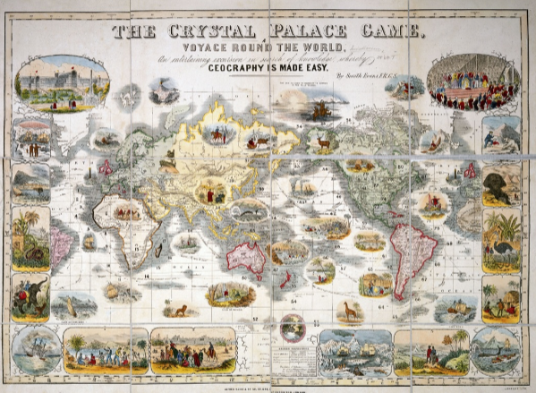
“The Crystal Palace Game” was created as an educational world map game by the Royal Geographic Society’s Henry Smith Evans around 1854 tocelebrate “The Great Exhibition of the Works of Industry of All Nations”. The brainchild of Prince Albert, consort of Queen Victoria, the exhibition
was held in Hyde Park, in London, between May and October 1851. Players followed a route past sea monsters, hostile tribesmen and other hazards through the distant corners of the British Empire. Intended to celebrate the country’s global dominance and influence in the Arts, Science Technology and Culture, the game board lives up to the motto that proclaims: “Britain, upon whose empire the sun never sets”:
was held in Hyde Park, in London, between May and October 1851. Players followed a route past sea monsters, hostile tribesmen and other hazards through the distant corners of the British Empire. Intended to celebrate the country’s global dominance and influence in the Arts, Science Technology and Culture, the game board lives up to the motto that proclaims: “Britain, upon whose empire the sun never sets”:
4) The history of pictorial maps, 19th and 20th century, in chronological order, with a description of the most striking examples
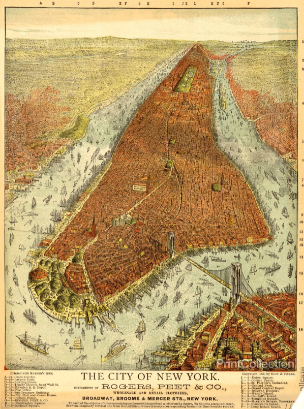
A panoramic map or bird’s eye view map was a popular cartographic form to depict U.S. and Canadian cities and towns during the 19th and early 20th century. The development of lithography in the nineteenth century created an opportunity for the development of major new markets for maps, and especially of counties and urban places. Lithography enabled inexpensive, single-sheet reproductions, however in only relatively small numbers.
This panoramic promotional bird’s-eye view of Manhattan Island is viewed from New York Harbor in the south and includes the Hudson and East Rivers as well as parts of Brooklyn, Queens and Bergen County and New Jersey on the opposite shores. The buildings and bridges are rendered in what appears to be accurate proportions in the lower part of Manhattan; elsewhere they are
indicated in a more generalised manner. The rivers have numerous clipperships and other vessels sailing the waters or are docked at wharves, with horse-drawn carriages and pedestrians crossing the Brooklyn Bridge.
indicated in a more generalised manner. The rivers have numerous clipperships and other vessels sailing the waters or are docked at wharves, with horse-drawn carriages and pedestrians crossing the Brooklyn Bridge.
5) Examples of a Paris pictorial / pictographic map
6) Satire & Caricature Maps in the first half of the 20th Century
6) Satire & Caricature Maps in the first half of the 20th Century
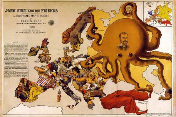
The serio-comic political cartoon map of Europe was designed by Frederick Rose and published in 1900. The famous map of Europe made up of caricatures of each country, highlighting the insecurities of the time, as explained by the text on the left. The main worry is the Russian octopus with the face of Tsar Nicolas II, with tentacles wrapped around the throats of Poland, Persia and China, one grabbing for Turkey's foot and another laid across Finland. England and Scotland are depicted as a soldier in tropical uniform, waving a Union Jack, with two wildcats, marked “Orange Free State” and “Transvaa”, savaging his legs. He sits on shells marked with their
destinations: India, Canada, South Africa and Australia. France beckons Germany to help her against Britain who she blames for her colonial upsets, and Italy stretches out a helping hand. Spain is mourning the recent loss of Cuba and the Philippines, her last important colonial possessions.
destinations: India, Canada, South Africa and Australia. France beckons Germany to help her against Britain who she blames for her colonial upsets, and Italy stretches out a helping hand. Spain is mourning the recent loss of Cuba and the Philippines, her last important colonial possessions.
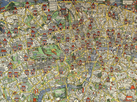
7) The history of pictorial maps from 1914 to 1945, exploring the influential work of MacDonald Gill with descriptions of the most striking examples.
Gill’s 1914 Wonderground Map of Central London managed to match fantasy with accuracy filling this very detailed map with poems, wordplays and satirical commentary on accent, class and social mobility, drawing its inspiration from Lewis Carroll's Alice in Wonderland. The Wonderground Map was a milestone and resurgence of decorative map making that would be copied and developed in America more than a decade later: Along with the large poster size of the map, perhaps the most immediately striking feature is the brilliant but simple coloration of red, yellow, green and
blue, certain to attract immediate attention. The city is presented in the manner of a medieval walled town, the curved horizon recalling the medieval world map’s enclosing circle, all bounded by a decorative border in which coats of arms evoke a sense of stability and tradition.....
blue, certain to attract immediate attention. The city is presented in the manner of a medieval walled town, the curved horizon recalling the medieval world map’s enclosing circle, all bounded by a decorative border in which coats of arms evoke a sense of stability and tradition.....
8) The history of pictorial maps from 1945 to 1960's, exploring monumental & pictographic maps with description of the most striking examples
Matthias told me that this started out as a research work inspired by his own love of pictorial maps. His work on the project continues and you can get an immediate download of "Introduction to Pictorial Maps" by clicking on this LINK
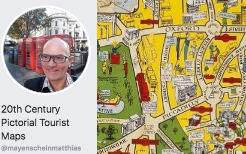
You can also find Matthias on Facebook at:
20th Century Pictorial Tourist Maps
The Facebook shop offers mostly 20th century pictorial and pictographic (monumental) maps.
You can contact Matthias directly at:
Mayenscheinmatthias@gmail.com
As always if you found this article useful especially id you have only just discovered the fascinating world of pictorial maps please leave a comment below. I would love to hear from you. . . .
0 Comments