- Published on
Some time ago I remember a buyer contacting me having purchased a Robert Morden map from me on ebay. They wanted to express their disapointment as on opening the package they had discovered that the map had a crease down the middle! Thats a true story and always amuses me when I think back to the event. But to be fare if a person has no knowledge or experience of antique maps, its unlikely they would know what to be looking for.
Previously I touched on looking at the paper itself. I'll try to making a short video on the paper issue in the coming weeks so you can see more clearly the differences I've already explained. The next important step is to know what to be looking for on the paper itself. Identifying elements is what you're after.
Back to our friend and the 'crease down the middle". The fact is most maps available to collectors today are printed maps that were originally bound into books and atlases. Most of the single maps available now were removed from these bound works in the past. So as you will appreciate if the map was once in an atlas or book, it will have a crease down the middle where it was folded. This made it possible for the map to be inserted and bound in a book or an atlas.
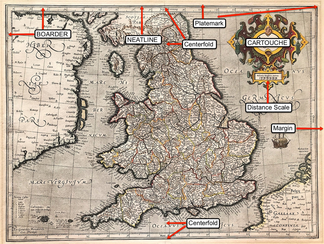
Above: Map of England & Wales 'Anglia Regnum' Duisberg 1595 by Mercator. I've used this map so you can see the basic identifiers on a 16th Century double page map. Printed maps were generally contained within a boarder, this may be a simple line. The outermost line is called the 'neatline' and the area beyond this to the edge of the sheet is called the 'margin'. All engraved maps have a platemark, you can just about see this on this image. If you were actually able to touch this map you would be able to feel the indentation in the paper. The paper within the platemark is slightly lower than the margin paper because it has been compressed. Last point on this for now, a maps size is measured by the area within the neatline not the sheet size. You would not include the margin of paper out beyond the neatline to the edge of the sheet.
This gives you some of the basic's of what to look for "on the paper" as identifiers for original maps of this period. Yes there is more to come . . . . Enjoy the hunt!
Click the link to continue to Part 5 in the Series Collecting Antique Maps
You can see full details of the Mercator 'Anglia Regnum' HERE
0 Comments

