|
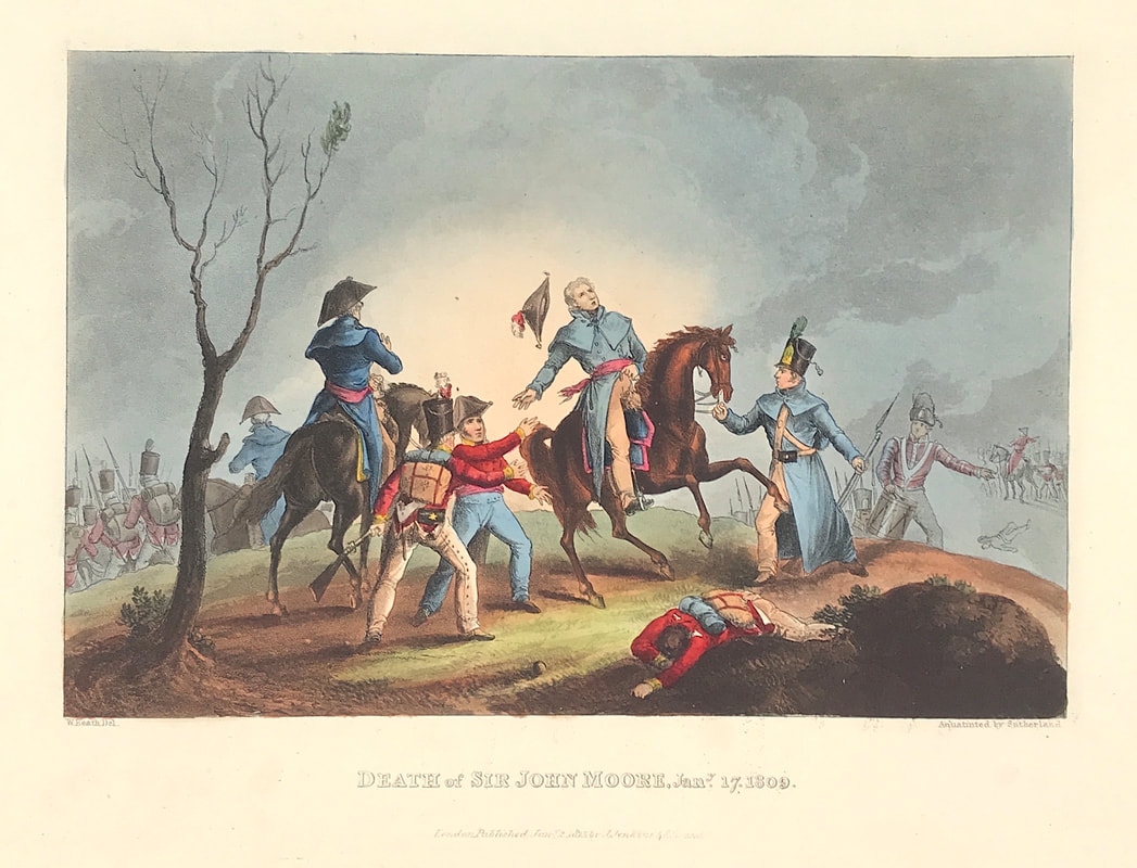
Another of the exceptional aquatint prints from Jenkins The Martial achievements of Great Britain and Her Allies from 1799 to 1815. Below the print is a short excerpt from the original written account as published with the print. Lieutenant-General Sir John Moore, KB was a British Army general, also known as Moore of Corunna. He is best known for his military training reforms and for his death at the Battle of Corunna, in which he repulsed a French army under Marshal Soult during the Peninsular War. Moore withdrew northwards to the port of Corunna. There he fought a skillful rearguard battle on 16 January 1809 that kept the French from attacking his embarking army. At one point in the fighting, Moore led two regiments back into the village of Elvina from where they had been ejected by the French. After firing a volley, they drove the French out at the point of the bayonet. Moore was mortally wounded by cannon shot during this engagement, but lived long enough to learn that he had been victorious. His last words were: ‘I hope the people of England will be satisfied! I hope my country will do me justice!’ Above: The Death of Sir John Moore January 17th 1809 from The Martial achievements of Great Britain and Her Allies from 1799 to 1815 by James Jenkins.
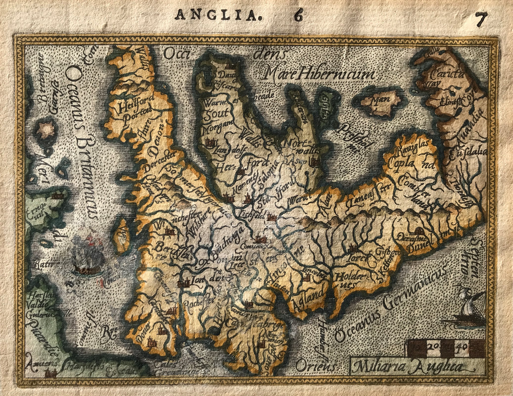
Excerpt from the written account as published: HAVING given a detail of the battle of Corunna in another part of our work, we shall confine ourselves to the documents now before us, relative to the death of the general who planned this glorious retreat, but who fell a victim to those plans, the accomplishment of which he was permitted to witness before he closed his eyes in death. Of the regretted hero of Corunna, Buonaparte was known to exclaim, “ Moore is the only general now worthy to contend with me; I shall therefore “ advance against him in person.” But to the relation before us. “I was ordered,” says Captain Harding, “by the commander in chief, to desire a battalion 6 of Guards to advance, and I was pointing out to the general the situation of this battalion; our“ horses were touching at the very moment that a cannon-shot from the enemy's battery carried “ away his left shoulder and part of the collar-bone, leaving the arm hanging by the flesh. The “ violence of the shock threw him off his horse on his back, yet did not a muscle of his face alter, “ or a sigh betray the least sensation of pain. I dismounted, and taking his hand, he pressed mine “ forcibly. He cast his eyes very anxiously towards the 42d regiment, who were botly engaged, and “ whom he had just before cheered by, “Well done, 42d! well done, my majors !' His countenance “ expressed satisfaction when I informed him the regiment was advancing. Assisted by a soldier “ of the 42d, he was removed a few yards behind the shelter of a wall, and at length assented “ to be removed in a blanket to the rear; but in raising him for this purpose, his sword, hanging on “ the wounded side, touched his arm and became entangled between his legs. I perceived the in “ convenience, and was in the act of unbuckling it from his waist, when he said, in his usual tone " and manner, and in a very distinct voice, “ It is as well as it is-I HAD RATHER IT SHOULD GO OUT * 6 OF THE FIELD WITH ME. They proceeded with him in a blanket to his lodgings at Corunna, “the soldiers shedding tears as they went." How to Identify the Prints: The original prints from The Martial achievements of Great Britain and Her Allies from 1799 to 1815 are aquatint engravings on a medium weight wove paper. Plates also exist that were printed on India Paper. They should clearly identify bottom left W. Heath (delt) who did the drawings and bottom right T. Sutherland (sculpt) who produced most of the aquatint engravings with some by D. Havell, M. Dubourg and J. Hill. Each plate has the date of publication and the name of the publisher beneath the engraved title. The approx engraved area of the plates are 8.5" x 7.75" (215mm x 195mm) including the engraved title text. Engraved plate mark area is approx 8.5 x 11.75 (215mm x 300mm). The large sheet size is approx 11.5" x 14" (290mm x 355mm). You can see more prints from Jenkins The Martial achievements of Great Britain and Her Allies from 1799 to 1815 HERE. If you're interested in a specific print and you cannot see it on my website please feel free to message me. I really am going to wind this up about the 'kinds of maps' available to newbie collectors. Trouble is I keep thinking of those I missed out! Well another for you is miniature maps. I've collected a few in my time, the example below is from part of an earlier collection I had. The so called miniatures came about for the simple reason that most early atlases were published in folio format and were simply too expensive for most people. With a market demand for something affordable the smaller atlases came into existence. The maps were based on the large folio maps already produced by various publishers. Understandably these smaller maps do not have the same level of detail as their larger counterparts but they still provide an interesting alternative for collectors. Smaller means, easy to store, less wall space and they can be purchased online with modest shipping costs. Not to be forgotten they will cost you less than the larger folio maps. Above: Map ANGLIA by A. Ortelius & P. Galle c1577 Dutch text, British Isles.
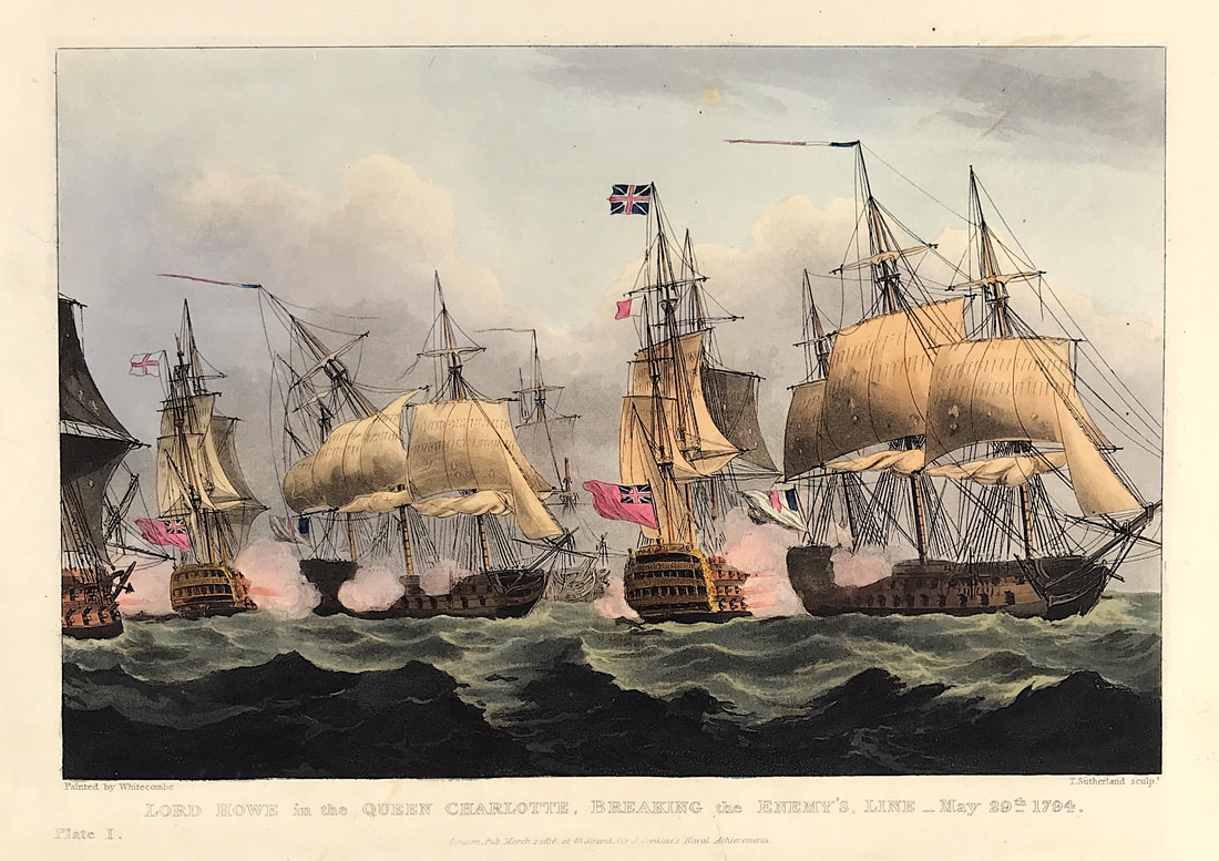
Published: Antwerp from Spieghel der Werelit. Pieter Heyns composed the rhyming text which is printed in Dutch on the reverse of the map. Printed by Christopher Plantin. The engraver is unknown. A very rare antique map - Oriented to the West - From the Collection of the late Rodney Shirley. This is the actual map from the Rodney Shirley's collection reproduced in his publication "Early Printed Maps 1477-1650" as Plate 27. Philip Galle, a publisher friend of Ortelius prepared the maps as reductions from those in Ortelius' atlas. "Galle drew on the Mercator outline of England, Wales and southern Scotland which appeared in the main Ortelius atlas...the map of England and Wales is crowned, with rivers, hills and county names indicated. West is at the top and the narrow border cuts off the tip of Cornwall and Norfolk" (Ref: R. W. Shirley Early Printed Maps of The British Isles 1477-1650 edition 1980 p51) These so called miniature maps in truth are miniature in name only they tend to be of a size approx 6 x 4 inches. These smaller maps have their own charm and interest, with less availability prices vary and in certain cases will demand a premium however they are well worth seeking out. The so called 'miniatures' may be just right for you. Happy Hunting! If you're wondering the map above is no longer available as it was sold to a collector in the USA. As promised another of the exceptional aquatint prints from James Jenkins The Naval Achievements of Great Britain. To give you even more of an insight into the event recorded I've shared a brief excerpt from the original written account published below the print. The French fleet of twenty-five sail of the line and fifteen frigates had sailed out of Brest in order to bring in homeward bound merchant ships. The fleet was discovered by the British on 28 May and battle was given on the 29th. The action was interrupted by fog and battle was not re-engaged until 1 June when the British fleet prevailed and captured seven vessels. Known as 'The Glorious First of June', this action was also known as the 'Third Battle of Ushant'. The British were commanded by Admiral Richard Howe, 1st Earl Howe (1726-99), and the French were commanded by Admiral Louis-Thomas Villaret de Joyeuse (1747-1812). The British defeat of the French was only a tactical victory, the objective of capturing a French grain convoy was not achieved. Above: Plate 1: Lord Howe's Victory, June 1st 1794. Published Apr 1st 1816 at 48 Strand for J. Jenkins Navel Achievements. From The Naval achievements of Great Britain and Her Allies from 1793 to 1817 by J. Jenkins.
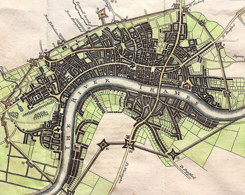
Excerpt from the written account as published: Lord Howe's Victory, June 1st 1794. At the commencement of the war in 1793, Admiral Howe was appointed to the arduous command of the Channel fleet; and powers seldom entrusted to a commander were wisely granted to him. By the short cruises he made, and the wise regulations he introduced, the fleet under his command was always ready to engage the enemy, and cleared the way for that brilliant achievement which followed. On the 19th May, 1794, being off Ushant, he received intelligence that the French fleet had put to sea from Brest, under the command of Admiral Villaret: he immediately made every preparation to follow them; and on the 28th a signal was made by one of the look out frigates for a strange fleet. The admiral immediately threw out the signal for the advanced squadron under Rear Admiral Paisley to reconnoitre, who, between nine and ten, discovered them to be enemies. On the 29th the admiral made the signal to form a line of battle ahead; but, being impatient to close with the enemy, he attacked the ship, and broke through the enemy's line. The battle continued with great fury till evening, when a thick fog prevented anything decisive from taking place. The annexed plate represents the Queen Charlotte passing between the enemy's ships and raking a three-decker. To the left is the Bellerophon, following the glorious example of the commander in chief, bringing down her opponent's top-masts and lower-yards with a starboard broadside, at the same time raking the one to leeward; the Leviathan, with the remainder of the fleet, just coming up . . . How to Identify the Prints: The original prints from "The Naval Achievements of Great Britain. From the Year 1793 to 1817" are aquatint engravings on a medium weight wove paper. All the plates identify at bottom left Painted by T. Whitcombe and bottom right T. Sutherland (sculpt) who produced the aquatint engravings. Some plates were engraved by Jeakes and Bailey after Whitcombe. Each plate is accompanied by text pages describing the action, often with lists of ships captured or sunk, and excerpts from contemporary bulletins, dispatches, letters, and speeches. The first edition appeared in 1817. Early issues have watermarks of J. Whatman with the undated watermark IIS&S on some plates. The vignette title page was uncoloured in the first issue. The approx engraved image area of the plates are 7" x 10.25" (175mm x 260mm). Engraved plate mark area is approx 8.5 x 11.75 (215mm x 300mm). The folio sheet size is approx 11.5" x 14" (290mm x 355mm). You can see more prints from Jenkins The Naval Achievements of Great Britain, From the Year 1793 to 1817 HERE. If you're interested in a specific print and you cannot see it on my website please feel free to message me. If you follow this blog, you'll be pleased to hear we're coming to the end of 'kinds of maps' that are available to collect by the newbie antique map enthusiast. Back in early November I started posting about the different kinds of maps available to collectors. Several post later as I suggested at the beginning to quote myself "One size fits all! That may be true with many things in this life but you'll quickly realise that its not the case with antique maps. In fact its more a case of every size, shape, form, subject, appearance and kind of antique map is out there if you look around." In reality I've just scratched the surface with these blog posts but hopefully its given you some solid suggestions as to what you can consider as a theme for collecting. Before concluding one not to be left out of any basic list is the 'Town Plan'. Any view straight down on a city or town showing its streets, parks, blocks of buildings etc is called a town plan or birds-eye plan. Again popular with collectors as its something most of us are familiar with with from modern mapping. Now of course if you're lost in a city somewhere in the world you're going to pull up the available town plan likely via Google maps on your mobile device. Above: The City And Environs Of London, As Fortified ....1642 & 1643 Published for Walter Harrison's History of London 1775. The map shows and a numbered key describes the fortifications put in place (and perhaps made of wood) to defend London from the Royalist forces in the Civil War. With no such attack forthcoming, they were demolished in 1647.
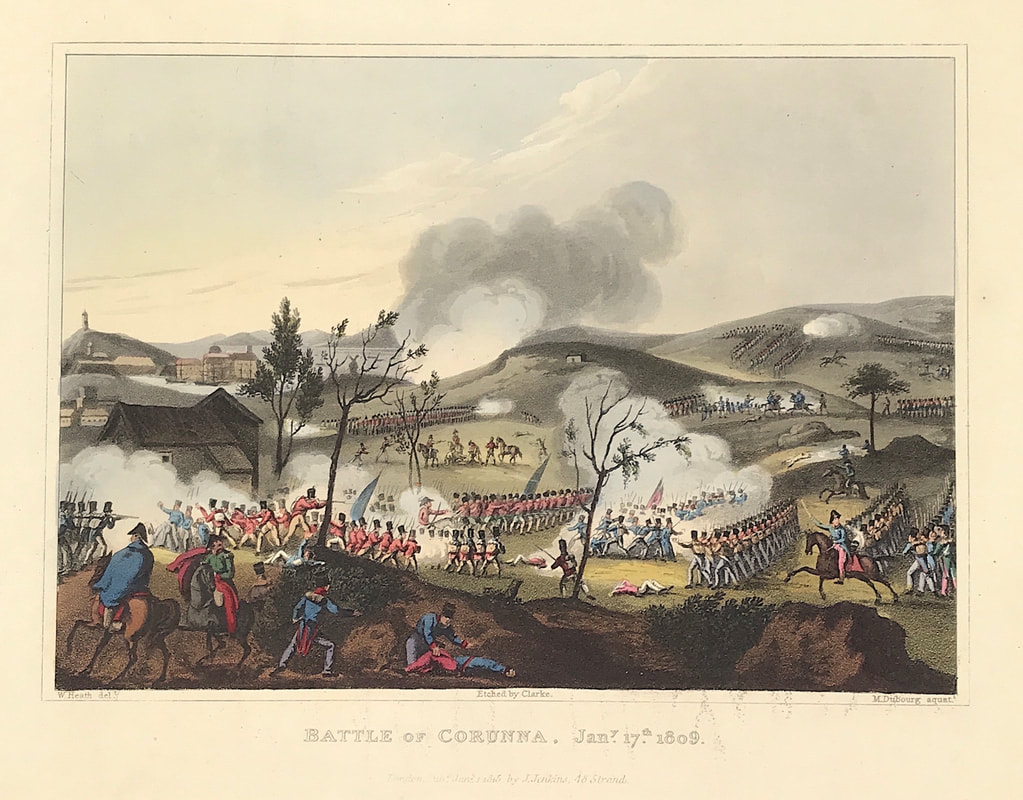
There were many town plans published in the nineteenth century and those published by the Society for the Diffusion of Useful Knowledge (SDUK) are among the most popular. Older plans like the on above of London are also popular but like with most things scarce they require a bit more searching to find. Happy Hunting! You can see more details about the town plan City of London and its Environs HERE. In my Etsy Shop section Views of London. As promised another of the exceptional aquatint prints from Jenkins The Martial achievements of Great Britain and Her Allies from 1799 to 1815. Below the print is a short excerpt from the original written account as published with the print. The battle of Corunna, also known as the Battle of Elviña, that ensured the escape of the British army from Spain on 16th January 1809, during the Peninsular War, with the death of Sir John Moore at the moment of success. The winners and losers, well the French; having forced the British army to retreat across north-west Spain, suffering substantial losses the British leave Spain by the port of Corunna. On the other hand, the French felt cheated that the British army was enabled to escape and the British troops considered they had performed well in the battle and their self-confidence was much restored. Above: The Battle of Corunna, January 17th 1809 from The Martial achievements of Great Britain and Her Allies from 1799 to 1815 by James Jenkins.
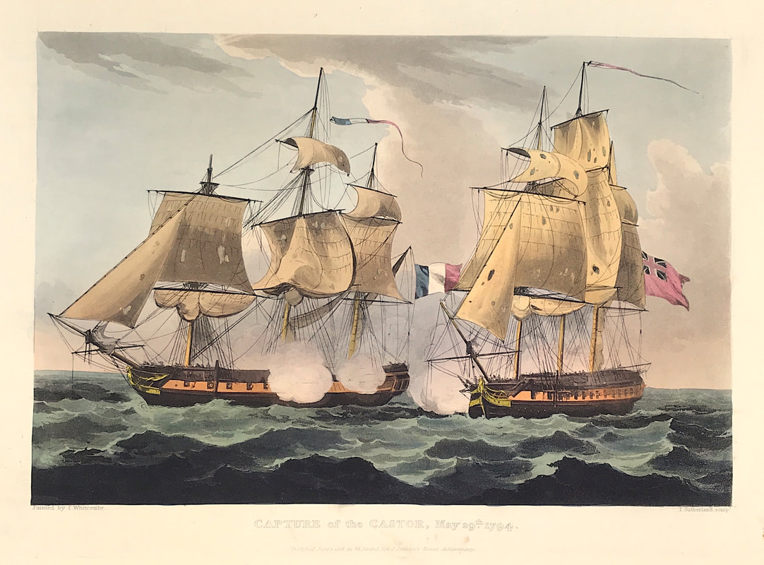
Excerpt from the written account as published: THE BATTLE OF CORUNNA. AFTER numerous trials and deprivations, the English army, under the command of General Sir John Moore, arrived at Corunna, entire and unbroken, January 11, 1809; and, in a military point of view, the operations were successful and splendid. Nearly 70,000 Frenchmen, led by Buonaparte, with a great superiority of cavalry, had endeavoured in vain to surround or to rout 26,000 British; 250 miles of country had been traversed; mountains, defiles, and rivers had been crossed in daily contact with the enemy. Though often engaged, even their rear guard was never beaten, nor thrown into confusion, but was victorious in every rencounter. Much baggage undoubtedly was lost, and some 3-pounders were abandoned, but nothing was taken by force. What was left was owing to the death of waggon-horses and mules, and not to the escort ever having been defeated. The courage and menacing attitude maintained by the cavalry and reserve were sufficient always to repel and overawe the advanced guard of the enemy; and at Lugo battle was offered by this handful of British to three divisions of French, commanded by their marshals. This challenge was declined, and the impression it made enabled the British to terminate the march almost undisturbed. . . . How to Identify the Prints: The original prints from The Martial achievements of Great Britain and Her Allies from 1799 to 1815 are aquatint engravings on a medium weight wove paper. Plates also exist that were printed on India Paper. They should clearly identify bottom left W. Heath (delt) who did the drawings and bottom right T. Sutherland (sculpt) who produced most of the aquatint engravings with some by D. Havell, M. Dubourg and J. Hill. Each plate has the date of publication and the name of the publisher beneath the engraved title. The approx engraved area of the plates are 8.5" x 7.75" (215mm x 195mm) including the engraved title text. Engraved plate mark area is approx 8.5 x 11.75 (215mm x 300mm). The large sheet size is approx 11.5" x 14" (290mm x 355mm). You can see more prints from Jenkins The Martial achievements of Great Britain and Her Allies from 1799 to 1815 HERE. If you're interested in a specific print and you cannot see it on my website please feel free to message me. Todays post of another superb aquatint print from James Jenkins The Naval Achievements of Great Britain shows the capture of the Castor. Castor had previously been a British ship, seized on 19 May by a French battle squadron in the Bay of Biscay and converted to French service while still at sea. While the main fleets manoeuvered around one another, Castor was detached in pursuit of a Dutch merchant ship and on 29 May encountered the smaller independently cruising British frigate HMS Carysfort. Above: Capture of the Castore May 29th 1794 from The Naval Achievements of Great Britain and Her Allies from 1793 to 1817 by J. Jenkins. The Castor, a British vessel captured by the French (and flying French colours) is shown on the left of the picture, just before her re-capture by the British vessel Carysfort.
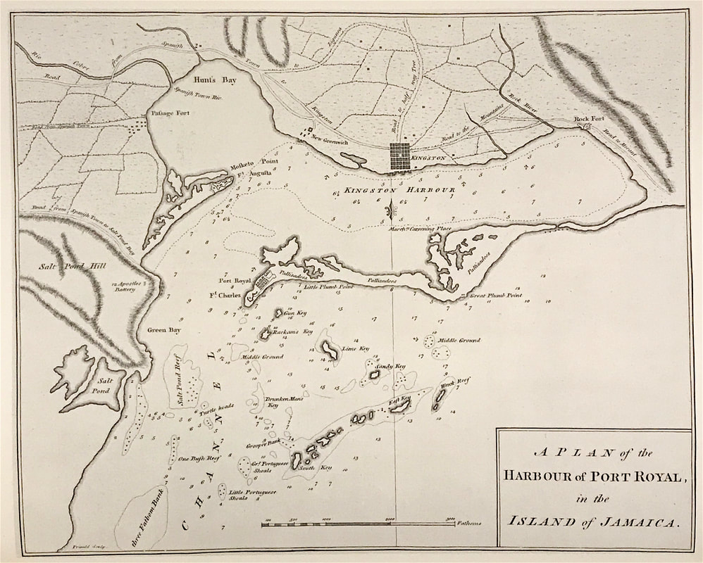
Excerpt from the written account as published: Capture of the Castore May 29th 1794. The following is an extract of a letter from Francis Laforey, Esq. Captain of his Majesty's ship Carysfort, of 28 guns, to Mr. Stephens, dated in Plymouth Sound, June 7, 1794. B. On the 29th of last month, being in latitude 46 deg. 38 min. north, longitude 9 deg. 40 min. west, his Majesty's ship under my command fell in with, and, after an action of an hour and fifteen minutes, captured, a French frigate (late his Majesty's ship Castor), commanded by Monsieur L'Huiller, mounting 32 guns, and manned with 220 men. She had parted company from the French squadron on the 24th, in chase of a Dutch brig, which she had in tow when we first discovered her, and which, upon our coming up, was enabled to effect her escape. I have the satisfaction of reporting to their Lordships the uniform good conduct of the officers and crew of his Majesty's ship that I have the honour to command; and I feel myself indebted to Lieutenants Worseley and Sayer, for the spirited example they set to a new ship’s company. Herewith I transmit a return of the loss sustained by his Majesty's ship in killed and wounded, with as accurate a one as we have been able to obtain of that of the enemy. (Signed,) F. LAFOREY. Carysfort.- One seaman killed; five seamen, one marine, wounded. Castor.- Sixteen seamen killed; nine seamen wounded. How to Identify the Prints: The original prints from "The Naval Achievements of Great Britain. From the Year 1793 to 1817" are aquatint engravings on a medium weight wove paper. All the plates identify at bottom left Painted by T. Whitcombe and bottom right T. Sutherland (sculpt) who produced the aquatint engravings. Some plates were engraved by Jeakes and Bailey after Whitcombe. Each plate is accompanied by text pages describing the action, often with lists of ships captured or sunk, and excerpts from contemporary bulletins, dispatches, letters, and speeches. The first edition appeared in 1817. Early issues have watermarks of J. Whatman with the undated watermark IIS&S on some plates. The vignette title page was uncoloured in the first issue. The approx engraved image area of the plates are 7" x 10.25" (175mm x 260mm). Engraved plate mark area is approx 8.5 x 11.75 (215mm x 300mm). The folio sheet size is approx 11.5" x 14" (290mm x 355mm). You can see more prints from Jenkins The Naval Achievements of Great Britain, From the Year 1793 to 1817 HERE. If you're interested in a specific print and you cannot see it on my website please feel free to message me. About 100AD a man known as Marinus of Tyre began drawing maps for the use of seaman based on a cylindrical projection forming a grid of parrelelograms centred on Rhodes, the marine focal point of the known world. It is only through the writings of one of the greatest geographers of all time that we know what we do of Marinus, for Ptolemy consciously built upon the formers work. Ptolemy wrote a great deal, his best known work being Geographia, in which he discusses cartography and lists the latitude and longtitude co-ordinates of 8,000 places, culled from ancient maps or estimated from a study of traveller's tales. Sea Charts then have been around some time, travel back to around 1800 and charting was showing a true picture of the world. Captain Cook had disproved the existence of a great southern continent and placed New Zealand on the map. The knowledge gained by the Dutch in the East-Indies in the seventeenth century was now gradually becoming available. Admiralty surveying and charting probably reached its peak in the early 1850's and the charts of the period may be admired for their accuracy and their fine engraving. Above: The Harbour of Port Royal, Jamaica. Captain Joseph Speer c1766. From Speer's The West-India Pilot London. Little is known about Capt Speer, but his West India Pilot epitomises the great interest in the Caribbean throughout the eighteenth century, mainly as a result of the rapid growth in the sugar trade.
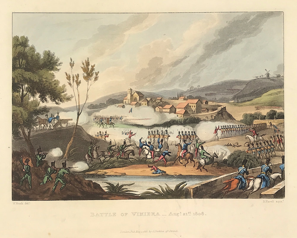
Sea Charts are a fascinating subject and another area of interest for the antique map or chart collector. These charts can describe seas, rivers and coasts in many parts of the world. Some show man-made features such as harbours and shore defences. They often include the best and most easily accessible maps of small oceanic islands. There are charts available of just about every part of the world constructed on large and small scales, in sheet and atlas form. Happy Hunting! Credit: Extract from 'The Sea Chart" Introduction by Rear-Admiral G. S. Ritchie CB DSC. c1973 Another of the exceptional aquatint prints from Jenkins The Martial achievements of Great Britain and Her Allies from 1799 to 1815. Below the print is a short excerpt from the original written account as published with the print. Sir Arthur Wellesley’s victory over the French army of Marshal Junot in Portugal on 21st August 1808, his first major victory in the Peninsular War, which nearly ruined his military career. In the Battle of Vimeiro (sometimes shown as "Vimiera" or "Vimeira" in contemporary British texts) on 21 August 1808, the British under General Arthur Wellesley (who later became the Duke of Wellington) defeated the French under Major-General Jean-Andoche Junot near the village of Vimeiro, near Lisbon, Portugal during the Peninsular War. This battle put an end to the first French invasion of Portugal. Above: The Battle of Vimiera August 21st 1808 from The Martial achievements of Great Britain and Her Allies from 1799 to 1815
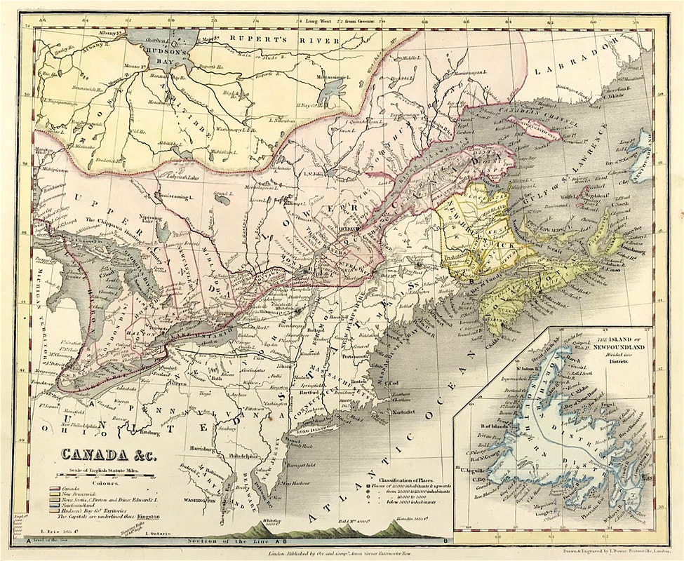
Excerpt from the written account as published: THE BATTLE OF VIMIERA. IN this desperate action the British troops were opposed to all the French forces in Portugal, commanded by the Duke of Abrantes, with a great superiority of cavalry and artillery, who sustained a total defeat, although not more than half the British army was engaged. The village of Vimiera, as it is correctly represented in the plate, stands in a valley, through which runs the river Maceira; and to the westward and northward of this village is a mountain, the western part of which touches the sea, and the eastern is separated by a deep ravine from the heights, over which passes the road which leads from Lourinha and the northward to Vimiera. On the eastern and southern side of the hill were posted the riflemen, commanded by Brigadier-General Fane, of whose assistance and bravery Sir Arthur Wellesley speaks in the highest terms of praise. Extract cf a Dispatch from Lieutenant-General Sir ARTHUR WELLESLEY i0 Limb-Gen. BURRARD. The enemy first appeared at eight o’clock in the morning, in large bodies of cavalry, on our left upon the heights on the road to Lourinha; and it was soon obvious, that the attack would be made upon our advanced guard and the left of our position. The attack began in several columns upon the whole of the troops on this height; on the left they advanced, notwithstanding the fire of the riflemen, close to the 50th regiment, and were checked and driven back only by the bayonets of that corps. The 2d battalion 43d regiment was likewise closely engaged with them in the road which leads into Vimiera, a part of that corps having been ordered into the church-yard, to prevent them from penetrating into the town. On the right of the position they were repulsed by the bayonets of the 97th regiment, which corps, successfully supported by the 2d battalion 52d regiment,by an advance in column, took the enemy in Bank. . . . How to Identify the Prints: The original prints from The Martial achievements of Great Britain and Her Allies from 1799 to 1815 are aquatint engravings on a medium weight wove paper. Plates also exist that were printed on India Paper. They should clearly identify bottom left W. Heath (delt) who did the drawings and bottom right T. Sutherland (sculpt) who produced most of the aquatint engravings with some by D. Havell, M. Dubourg and J. Hill. Each plate has the date of publication and the name of the publisher beneath the engraved title. The approx engraved area of the plates are 8.5" x 7.75" (215mm x 195mm) including the engraved title text. Engraved plate mark area is approx 8.5 x 11.75 (215mm x 300mm). The large sheet size is approx 11.5" x 14" (290mm x 355mm). You can see more prints from Jenkins The Martial achievements of Great Britain and Her Allies from 1799 to 1815 HERE. If you're interested in a specific print and you cannot see it on my website please feel free to message me. While we're still on the subject of 'kinds of maps' that are available to the newbie antique map collector, here's another one for you. Thematic Maps will need to be added to your list of possibilities. The range of themes is just about unlimited and generally cover physical, political, economic and social aspects connected with a specific geographical area. If geography and especially mountain ranges are of interest to you then the map below is for you! Above: Antique Map of Canada c1840. Shows Classification of Places, Population and Mountain Ranges Height above Sea Level. Drawn and Engraved by John Dower, Pentonville London.
Many of these maps came into existence in the first part of the nineteenth century with the onset of the Industrial Revolution. The rapid technical advances in mapmaking and colour printing making this possible. The field of thematic maps is vast and interesting and its an area where you can build a collection for a relatively modest financial investment. Happy Hunting! You can see more of these 'Mountain Range' maps on my etsy site HERE, |
LEARN ABOUT MAPS Where to Start? The Paper Earliest Maps Whats on the Paper? Rectum & Recto Marketing Devices Why Changing Faces? What is Ornamentation? Why all those lines? The Embellishment Story Illogical Prices Explained A Reference Library CLICK THE BOOK
Get the FREE Guide!
COLLECTING MAPS
Size Matters! Celestial Maps Strip Road Maps Sea Charts On the River of Life Projections The Sea Monsters Thematic Maps Town Plans Buy with Confidence. . .
More Top Tips for the Novice. Click the book to find out more . . .
COLLECTING PRINTS
Views of River Thames
Views of London Shipping & Craft Meet the Fairies Maritime Naval Military Battles Botanical Historic Churches Historic Views of Rome Archives
May 2024
|

