|
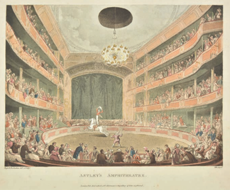
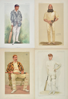
The pleasure in collecting antique prints is enormous and every one tells its own story. The range of subjects covered is almost endless. Just about everything that people have ever done is reflected in the print. The variety of prints produced means there is just about something for everyone and many antique prints are still enjoyed today proudly on display in the collectors home. So what about prices? Just like with map collecting there are a range of factors that together determine and influence prices. You have dealers, auctions, serious collectors, casual collectors, institutions and people who buy prints simply as decorative items. Nowadays you often get interior designers picking up prints in auction for some specific home refurbishment project or looking to add that touch of the ‘unique’ to their interior design theme. All these factors create fluctuation in the overall market and differing prices. Here’s a look at some recent sale prices of antique prints from just a handful of popular subjects. Most are stocked by regular print dealers and as with anything, the more scarce an item the more likely you are to pay a premium price.
The prices achieved for these prints at auction are closer to what is known as a 'dealer' price. All would cost you more if you were buying retail from a reputable antique print dealer. If you have an interesting print buying experience please tell us about it by leaving a comment below.....
Thanks as always to Dominic Winter Auctions for print images and auction results. More HERE. Yes that’s 200,000 euros for an 11-volume 16th century Le Grand Atlas by Joan Blaeu c1663. If you’re wondering what all the fuss is about please read on and admire the beauty and craftsmanship of this exceptional work. I've included some images and the background as provided within the catalogue. 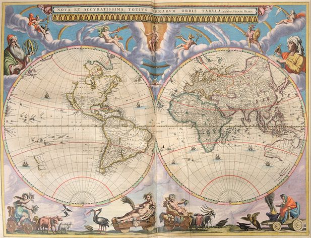 BLAEU, Joan. Le Grand Atlas, ou Cosmographie Blaviaene, en laquelle est exactement descritte la Terre, la Mer, et le Ciel. Amsterdam, J. Blaeu, 1663 [-1662] 10 (of 12) + 1 vols, in all 11 vols folio: 1 allegorical frontispiece, 7 engr. title pages, 533 engr. maps, plans, views and plates, mostly double-paged and all mounted on lvs, finely hand-coloured with details heightened in gold (repairs in vols I, VIII, minor browning, staining and foxing, some margins cropped, some maps wrinkled, some tears, a few wormholes). 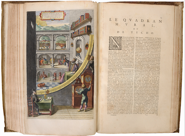 Dutch bindings: white ivory vellum over pasteboards with double ornamental gilt frame and gilt centerpiece, handwritten title on ornamented flat spine, gilt edges, remains of green silk ties (traces of glued paper on the inside of vols V-VI, VIII; traces of red wax on the inside of the covers of vols II, VII, X-XII; slightly damaged and loose spines on vols I-II, VI; some stains partic. at the bottom of vol. I). Extraordinary copy of the first French edition of Blaeu's "Atlas Maior", described as the "greatest and finest atlas ever published" (cf. H. de la Fontaine Verwey). Our set consists of 10 (out of 12) volumes with French text published in 1663 (vol. IV on the Low Countries missing) plus the Latin variant of vol. IX on Italy, dated 1662 and originally being part of the first edition of the "Atlas Maior". Compared to the Latin edition of 1662, our French one is considerably enlarged, making the volume on France too thick for one binding and, therefore, was split into two making a total of 12 vols. 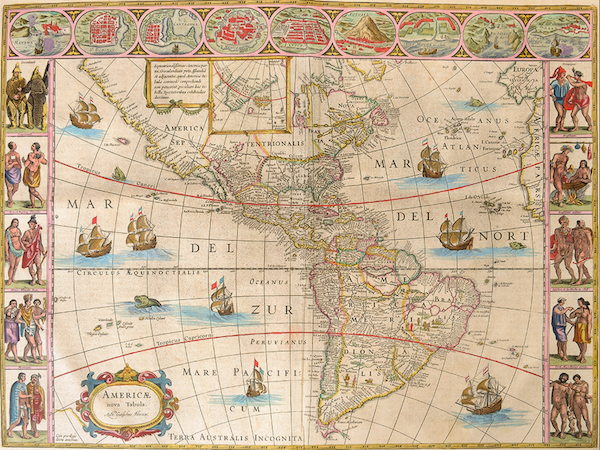 Only 30 copies of this French edition are known. Volume I. Arctic, Norway and Denmark. With its rare engr. frontispiece "Geographia Blaviana" (cropped and underlaid) and 61 maps incl. the magnificent world map in two hemispheres. Volume II. Sweden, Russia, Poland, southeastern Europe, and Greece. 39 maps. Volume III. Germany. 96 maps. Volume V. England. Engr. title page and 58 maps. Volume VI. Scotland and Ireland. Engr. title page and 55 maps. Volume VII. France (part 1). Engr. title page and 36 maps. Volume VIII. France (part 2) and Switzerland. 36 maps. Volume IX (Latin vol. VIII). Italy. Engr. title page and 60 maps, identical to the French vol. it substitutes. Volume X. Spain and Africa. Engr. title page and 41 maps. Without the rare engr. frontispiece on Africa. Volume XI. Asia. 2 engr. title pages and 28 maps. Volume XII. America. 23 maps. Ref. van der Krogt II [2: 611]. 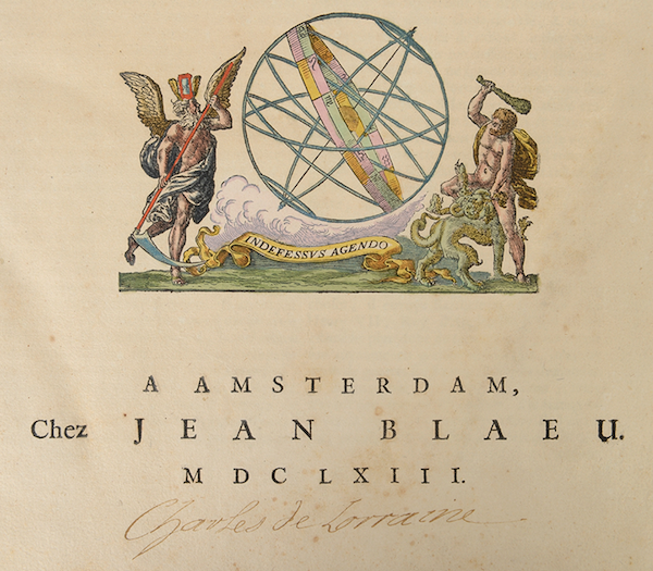 Prov. From the library of the Brussels' palace of Charles Alexander of Lorraine with ownership mark in gold pen by his own hand. According to the "Catalogue des livres de la bibliothèque [...] commencé en 1753", our copy is one of the highlights of the "Grande Bibliothèque" of Charles Alexander of Lorraine (1712-1780), governor of the Austrian Netherlands. After his death, Corneille-François de Nélis established a new catalogue from August 1780 onwards. Subsequently Emperor Joseph II, his "neveu par alliance" and legal heir, ordered the public sale of the collections. Hence, our "Grand Atlas" is listed as nr 1639 in the auction catalogue by Joseph Ermens ("...12 vol. in fol. rel.[iés] avec des Cartes & Estampes très proprement enlum.[inées]") and sold for "26 florins argent de change". 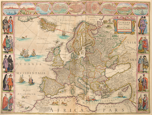 Charles Alexander's ownership mark is present on 9 title pages (not in vols I and IX). Ultimately this copy moved to the collection of de Ligne Ref. AGR, SEG 2610 and 2621. - AGR, CF 7639. - Catalogue des livres, estampes, et planches gravées, de la bibliothèque de feue S.A.R. le duc Charles-Alexandre de Lorraine [...]. Brussels, Joseph Ermens, 1781, Nr. 1639. If you enjoyed this post, please take a moment to leave a comment below... Thanks to Arenberg Auctions If you’re a newbie to antique maps or at the early stages of building a collection you’ve probably already experienced feelings of confusion or dismay at the outcome of what some maps sell for. Sometimes it just all seems illogical and buying under such circumstances is a real problem. Truth be told there are many factors that together determine and influence the price of a map. If you just consider how the market itself is made up, it gives you some idea why there is such apparent variation in the antique map market. You have dealers, auctions, serious collectors, casual collectors, institutions and people who simply buy maps as decorative items. All this creates fluctuation in the overall market and there can be a wide price difference for the same map in differing markets. Why So Much Variation? You have the simple fact that some maps of certain parts of the world are collected more than others. Then there are the maps that are bought and sold more frequently, which tends to create a relatively narrow more stable price range for these maps. At the other extreme you have scarce or more unusual maps that can sometime demand almost whatever the seller wants when it comes to price. There really is no one determining factor that sets a maps price and you could easily fill a small book explaining the various issues that should be taken into consideration. I’ll do my best to cover some of these in future posts.
Get a Fix on the Potential Sale Price One thing you can do is research online into current and historic price data. A simple way is to take a look at auction sales data. Most auction houses give an estimate on an items potential sale price. Obviously this can be far exceeded on occasion and this is because the market itself decides the value on the day. Just consider the factors already mentioned above. Who is buying, why are they buying, what are they buying the map for? All will have an affect on what price will be paid. This is why your own research is so important. Keep in mind also, auction houses charge a commission on the purchase price so this must be factored in when buying.
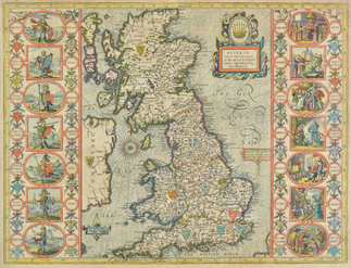
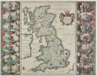
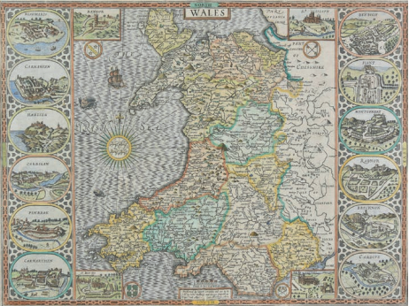
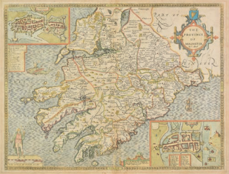
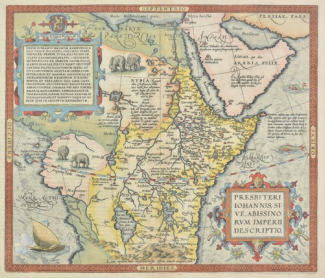
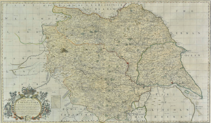
The Market Speaks! The maps shown here are examples of popular maps sold in the last week here in the UK (April 2019). These maps are generally available in the market with the exception of the last map of Yorkshire by Philip Overton. The others are normally found in the possession of most map dealers who sell to the retail market. The prices achieved for these maps at auction are closer to what is known as a 'dealer' price. All would cost you more if you were buying retail from a reputable antique map dealer.
If the maps of John Speed or Johannes Blaeu are of interest to you you can find some English county maps on the site HERE. If you have an interesting map buying experience please tell us about it by leaving a comment below..... Thanks as always to Dominic Winter Auctions for map images and auction results. More HERE.
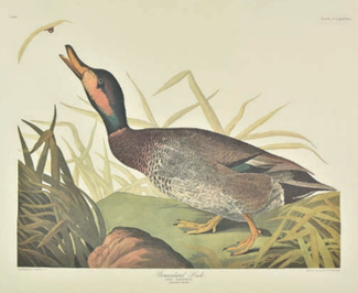
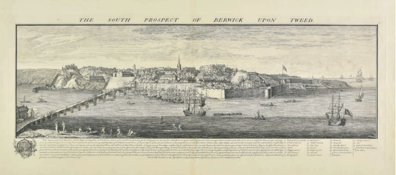
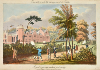
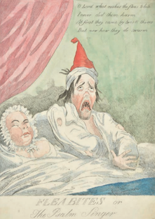
Topography is the study of places such as towns, districts, parts of the countryside, buildings and their settings. Before photography, engravings and etchings were the only means by which people could learn about the appearance of the scenery, great houses and ancient monuments of the land. The years between 1730 and 1870 were the great age of the topographical print. Many places have been captured at a moment in time by means of a print. Maybe you have a favourite from this period. Such prints were the reproduction of a design incised into a metal plate by one of a number of methods, or engraved on a block of wood or drawn on a slab of stone or zinc. What are you captured by? Some of these plates are now rare and expensive collectors’ items. Others can still be bought for a few pounds. What often fascinates us is the fact that the place is captured at that moment in time, it sometimes holds a special significance to us or is associated with some story that has captured our imagination. Sometimes it’s a combination of the place, scenery and the method that was used to reproduce the image that holds a special attraction. Aquatint is a complicated process which I am not going to delve into here. Produced in black and white or coloured, the later were finish with hand colouring. The first English prints in aquatint were made by Peter Burdett in or about 1771 after paintings by John Mortimer and Joseph Wright. Paul Sandby was the first Englishman to use it extensively. Within a few years the great productions of the major publishers, the Boydells, Ackerman and Bulmer began to appear. Major Colour Publications One of these was the Boydell’s History of the River Thames, containing seventy-six plates aquatinted by Joseph Constantine Stadler after the watercolours of Joseph Farington and first published in 1794. 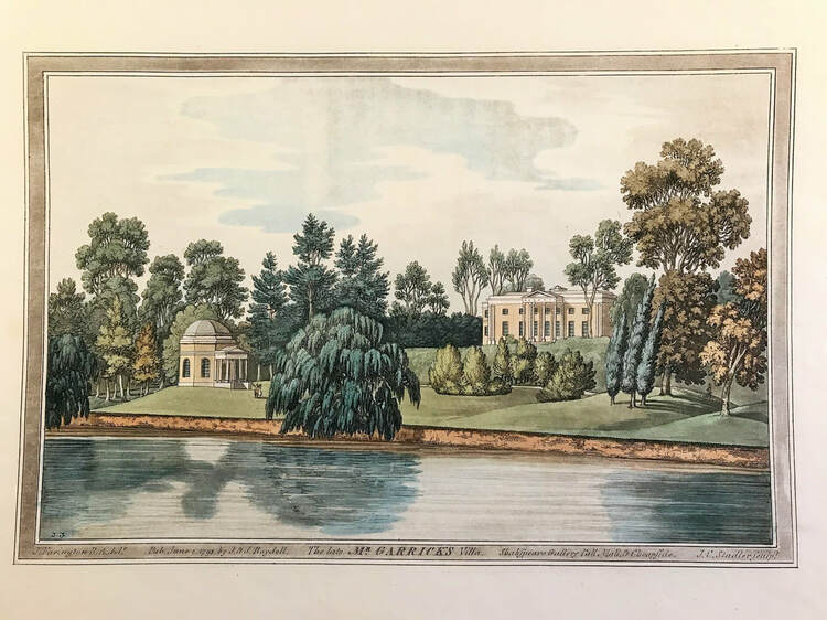 Garrick's Villa c1793 by Farington, Stadler col. Volume I, Plate 45 From Joseph Farington's 'History of the River Thames', 1794 Click for more. Many of the most important collections of aquatints were published by Rudolph Ackermann, who opened his print shop in the Strand in 1795 after emigrating from Germany and marrying an Englishwoman. His shop - the Repository of Arts - eventually replaced Boydells’ establishment as the focal point of the print trade. Aquatint became his speciality and he employed a large number of colourists to finish plates, most of which were printed in only one or two basic colours. 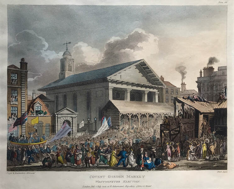 Covent Garden Market, Westminster Election c1808 Rowlandson & Pugin from Ackermann's Microcosm of London. Click for More. Ackermann attracted major artists, the best known are Thomas Rowlandson and Augustus Pugin. Pugin did the buildings and Rowlandson the figures for some of Ackermann’s most successful undertakings, including the three volumes The Microcosm of London collected in 1810 from a succession of monthly parts.
What is Your Favourite Place? I’m extremely fortunate to live very close to the River Thames and London. As a lover of aquatint the images shown here are places I know well and the method used to produce them fascinates me. Do you have a favourite place in England or somewhere else in the world? Do you have old prints of that favourite place? I’d love it if you could share by commenting below…… When we think about collecting rare or decorative prints those of us in the UK are likely to think closer to home. Maybe British topographical prints of the eighteenth and nineteenth centuries. The beautiful aquatints of picturesque views and architectural splendours, the engravings after the superb landscape watercolours of J. M. W. Turner or the lithographs of the early railway era to mention just a few. But what about further afield? What about the highly prized prints and documents of other parts of the world like Baghdad, Uzbekistan, Tajikistan, Damascus, Egypt, Kashmir, India and Morocco or Kuwait? Kuwait has a cultural heritage dating back to antiquity and Kuwaiti Researcher Mohammad Kamal's personal museum boasts many rare ancient Holy Quran copies, and Islamic documents and antiquities. 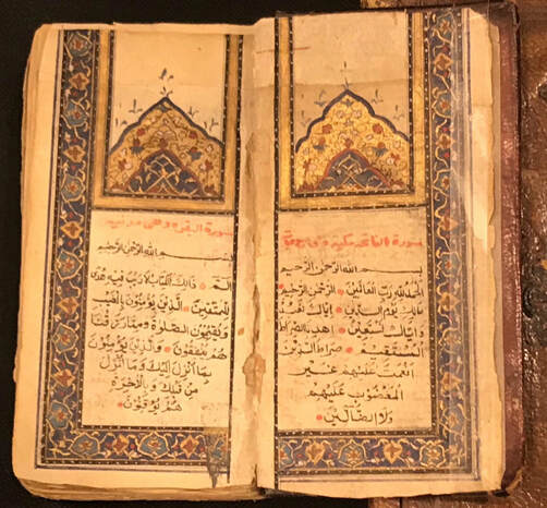 Kamal owns many 150 to 650 year old gold-engraved Quran prints that come from Baghdad, Uzbekistan, Tajikistan, Damascus, Egypt, Kashmir, India and Morocco. He has participated in many specialised exhibitions and events where unique ancient Islamic antiquities are put on display.
Know what you’re looking for: He is fond of collecting old and rare manuscripts, noting that he owns some documents that date back to the 3rd and 4th century After Hijra. He explains that every era has its own engraving characteristics that help in identifying where and when documents were printed, the elaborate carvings have different colours, including rose, blue and saffron. The colours differ from one country to another, Indian and Kashmiri Quran, for example, is brown, but the Ottoman one’s are lighter. Take advantage of technology? Kamal noted that he travels around the world searching for Quranic copies and rare Islamic items, pointing out that thanks to technology it is now easier to find them online through different auctions or antique stores. Are you using available technology with your own treasure hunting? The benefits of using online technology enables you to take advantage of weekly auctions from around the world. All from the comfort of your own home and laptop. Yes you must know what you’re looking for, the items current market value within reason and is the item specifically what you are looking for. Most auction houses will do all they can to answer your questions. - If your not already doing it, get on top of the technology and get started with your very own international treasure hunt! (Source: Kuwait News Agency/Saud Sultan) At first glance the title to this post appears to state the obvious. However if you have just a hint of knowledge about the fascinating world of maps you'll appreciate that old maps exist in a vast variety of forms, let alone the many differences in shape, size, subject and appearance. So it's fair to ask what do collectors collect?
Here are three types of map that map enthusiasts love to collect. These examples will help you get an idea of what exists and what they look like plus if you follow the links you can get more background information to the maps, their makers and history. All have a special reason of interest for collectors as varied as the very collectors themselves. This is three types or styles of map that are collected: Map Projections: Representations of the curved surface of Earth or a celestial sphere drawn on a flat surface. Here’s what is often referred to as a miniature map. The link below takes you to an example that is over three hundred years old. Its a map of the ancient world by Alain Mallet c1684 Ancient World by Alain Mallet c1684 Hemisphere Projections: These convert half of the spherical world to a circle. Here’s a link to an example over two hundred and eighty years old, a very collectable large map of the Eastern Hemisphere c1730 "Orbis veteribus noti tabula nova" by Guillaume Delisle (1675-1726) Eastern Hemisphere by Delisle c1730 Sea Charts: These are often coastline maps with additional information for traversing large areas of sea. Here is a small example of a Chart of the Western or Atlantic Ocean by Thomas Bowen c1788. A Chart of the North Atlantic showing the routes from Europe to Africa and across the Atlantic to the West Indies and the plantations of America. This is a good example of a small collectable copper engraved chart. Atlantic Ocean by Thomas Bowen c1788 This gives you a tiny taste of the kind of maps that are collected and are still available in the current market. If these types of maps are something you already collect I'd love to hear why they interest you? Please join in the conversation and leave a comment below..... |
LEARN ABOUT MAPS Where to Start? The Paper Earliest Maps Whats on the Paper? Rectum & Recto Marketing Devices Why Changing Faces? What is Ornamentation? Why all those lines? The Embellishment Story Illogical Prices Explained A Reference Library CLICK THE BOOK
Get the FREE Guide!
COLLECTING MAPS
Size Matters! Celestial Maps Strip Road Maps Sea Charts On the River of Life Projections The Sea Monsters Thematic Maps Town Plans Buy with Confidence. . .
More Top Tips for the Novice. Click the book to find out more . . .
COLLECTING PRINTS
Views of River Thames
Views of London Shipping & Craft Meet the Fairies Maritime Naval Military Battles Botanical Historic Churches Historic Views of Rome Archives
May 2024
|