|
For those new to collecting antique maps the passion sometimes starts with just wanting to put something on the wall. Now you're thinking maybe a map would look the part. Before you even get into anything serious and asking questions like what should I collect? or even how do you get started with collecting? At this stage its more, what will look good on the wall? If that's you then maybe consider a map of the world or some kind of map projection. This is a good place to start. Hemisphere projections are those maps you see that convert half of a spherical world to a circle. These hemispheres kind of change how we see the world. They are normally centered on the Western-Eastern or Northern-Southern hemispheres. The larger hemispheres also look pretty impressive with a well selected mount and frame. This could be you're first choice in starting with a map thats really a piece of wall art for your home. Also it's bound to be a conversation starter when you have you're friends around for dinner! 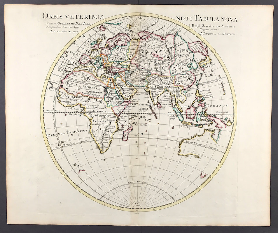 Above: Original Antique Map c1730 "Eastern Hemisphere" Orbis veteribus noti tabula nova by Guillaume De L'Isle (1675-1726) Published: Amsterdam, J Covens & C. Mortier. Approx engraved area: 19.5" X 19.5".
This early eighteenth century French cartographer was renowned for the accuracy of his maps. Australia is shown according to the two voyages of Abel Tasman 1642-1644. De L'Isle studied under Jean Cassini and from an early age showed his talent. De L'Isle is important as the first "scientific" cartographer who incorporated the most current information on exploration and topography into his maps. Where he was unable to verify information conclusively, he would note the fact on his maps. You can see the full details for "Orbis veteribus noti tabula nova" HERE Scotland is world famous for its castles, not just because so many are immaculately preserved but also because many are set against some of the most breathtaking scenery in Britain. Dunstaffnage Castle is a partially ruined castle in Argyll and Bute. The castle dates back to the 13th century, making it one of Scotland's oldest stone castles, in a local group which includes Castle Sween and Castle Tioram. Guarding a strategic location, it was built by the MacDougall lords of Lorn, and has been held since the 15th century by the Clan Campbell. You can google Dunstaffnage Castle and see pictures of the partial ruins that still remain today. Whats fascinating with those of us that collect old prints is we get a chance to see places at a moment in time from the past and enjoy the breathtaking scenery of that time, often a couple of hundred years ago. 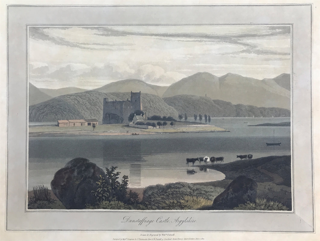 Here is Dunstaffnage Castle, Argylshire c1817 Drawn & Engraved by W. Daniell. Published: Dated June 2nd 1817 Longman & Co. Paternoster Row & W. Daniell, Cleveland St. Fitzroy Square, London. Another coloured aquatint from the "Voyage around Great Britain". These plates were unsurpassed for their subtle gradations of tone and their confident composition.
From William Daniell's 'A Voyage Round Great Britain', a series of 308 aquatints published in eight volumes between 1814-1825, described by R.V. Tooley as 'the most important colour plate book on British Topography'. William Daniell's A Voyage Round Great Britain was the most ambitious of the many topographical publications produced in England during the early nineteenth century and its plates are a highpoint in the history of aquatint engraving. You can see the full details of this aquatint by William Daniell HERE Collecting Antique Maps - Original or Reproduction? It's Got a Crease Down the Middle! Part 49/23/2020 Some time ago I remember a buyer contacting me having purchased a Robert Morden map from me on ebay. They wanted to express their disapointment as on opening the package they had discovered that the map had a crease down the middle! Thats a true story and always amuses me when I think back to the event. But to be fare if a person has no knowledge or experience of antique maps, its unlikely they would know what to be looking for. Previously I touched on looking at the paper itself. I'll try to making a short video on the paper issue in the coming weeks so you can see more clearly the differences I've already explained. The next important step is to know what to be looking for on the paper itself. Identifying elements is what you're after. Back to our friend and the 'crease down the middle". The fact is most maps available to collectors today are printed maps that were originally bound into books and atlases. Most of the single maps available now were removed from these bound works in the past. So as you will appreciate if the map was once in an atlas or book, it will have a crease down the middle where it was folded. This made it possible for the map to be inserted and bound in a book or an atlas. 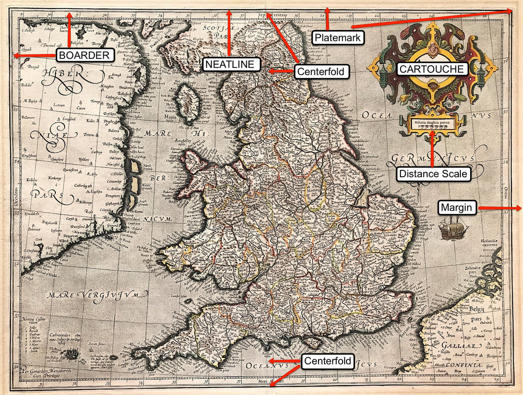 Above: Map of England & Wales 'Anglia Regnum' Duisberg 1595 by Mercator. I've used this map so you can see the basic identifiers on a 16th Century double page map. Printed maps were generally contained within a boarder, this may be a simple line. The outermost line is called the 'neatline' and the area beyond this to the edge of the sheet is called the 'margin'. All engraved maps have a platemark, you can just about see this on this image. If you were actually able to touch this map you would be able to feel the indentation in the paper. The paper within the platemark is slightly lower than the margin paper because it has been compressed. Last point on this for now, a maps size is measured by the area within the neatline not the sheet size. You would not include the margin of paper out beyond the neatline to the edge of the sheet.
This gives you some of the basic's of what to look for "on the paper" as identifiers for original maps of this period. Yes there is more to come . . . . Enjoy the hunt! Click the link to continue to Part 5 in the Series Collecting Antique Maps You can see full details of the Mercator 'Anglia Regnum' HERE What is it about botanical prints? It's like bringing the outside indoors. The level of meticulous detail, delicate hand colouring and effort in producing these prints in the eighteenth and nineteenth century continues to bring new admirers today. You can just about walk down any high street and the boutique home stores have large reproductions of such prints for sale demonstrating their popularity. Beautiful exotic prints displayed in the home are on trend, but collectors seek out the original prints, these are the real gems. The peak of botanical illustration sits between 1750 to around 1850. As improvements in printing were made, initially in engraving and later lithography, beautiful illustrated botanical books were produced. The work of the artist Pierre-Joseph Redouté on Roses is well known, maybe you've heard of him, however these are high priced. An edition of Redouté Les Roses in three volumes with 184 fine stipple-engraved plates printed in colours and finished by hand, sold in the UK in 2019 for a hammer price of £4000. Maybe starting somewhere a little more accessible on price would be good? There are many to choose from but the work of Jean Jules Linden (1817-1898) is often found in the market and affordable. Jean Jules Linden was an influential horticulturist and publisher, especially in the realm of orchids. Born in Luxembourg he published one of the finest botanical periodicals of the latter half of the 19th Century, L’Illustration Horticole. 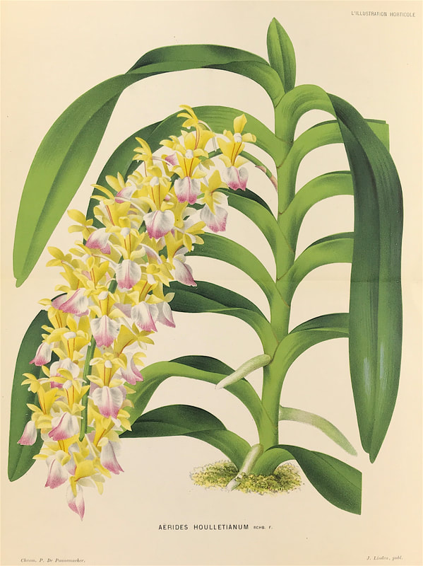 This exquisite antique Botanical print "Aerides Houlletianum" the Fox Brush or Cats tail Orchid is from L'Illustration Horticole, one of the great Belgian horticultural periodicals of the 1800s. Published from 1854 to 1896, L'Illustration Horticole featured a monthly review of noteworthy plants for the greenhouse and garden. Included were descriptions, illustrations, history and advice on cultivating the plants. Linden revolutionised the way orchids were grown in European collections. Before Linden all orchids were cultivated in hothouses at high temperatures. Many plants died, Europe was known as 'the orchid graveyard'. Based upon Lindens observations the British botanist Lindley described the plants he collected and included the information on the natural growing conditions. His firm grew into a true horticultural empire that at its zenith had outlets in Brussels, Ghent and Paris. Awards were won at international exhibitions in London, Paris and St. Petersburgh. Linden published wonderful books on orchids containing beautiful lithographs. He published one of the finest botanical periodicals of the latter half of the 19th Century, L’Illustration Horticole. You can see more prints by Jean Jules Linden in my ETSY Shop HERE When it comes to getting started with map collecting and specifically English map makers nine times out of ten you'll hear mentioned the names Saxton and Speed. These are certainly popular with new collectors and you will see their English County maps for sale at auction on a regular basis. These names dominate and rightly so however this is really just the tip of the iceberg. At the beginning of the eighteenth century the Dutch map trade was finally in decline. All through the eighteenth century the work of Saxton and Speed continued to dominate, however a number of other English map makers came on the scene. I'm sure I'll get to share work from all these cartographers with you in future posts but for now lets just take one example Thomas Kitchin. Kitchin (1719–1784) was a British cartographer, engraver and eventually became a publisher. He was born in Southwark, England, the eldest of several children. He was apprenticed to the map engraver Emanuel Bowen from 1732 to 1739, and he married Bowen’s daughter, Sarah, in December 1739. By 1741 Kitchin was working independently and in 1746 he began taking on apprentices at his firm. His son Thomas Bowen Kitchin was apprenticed to him starting in 1754. 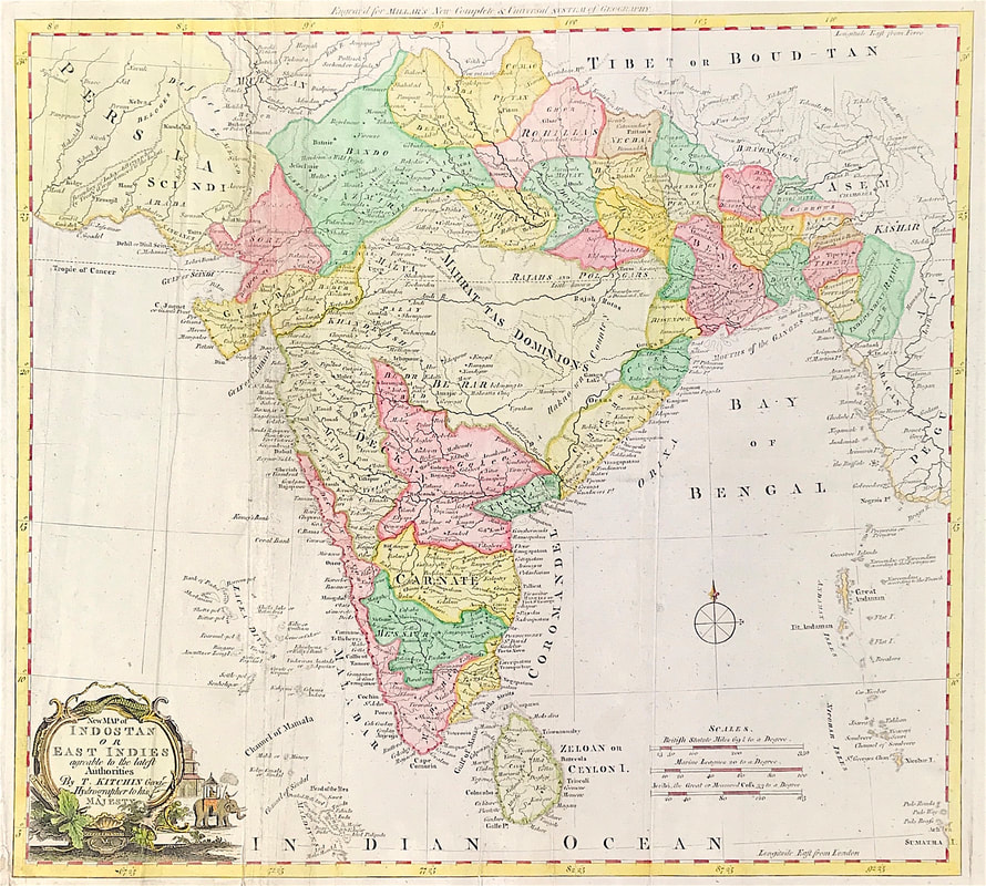 Above: A New Map of Indostan or East Indies agreeable to the latest Authorities c1770 by Thomas Kitchin Geographer & Hydrographer to His Majesty the King. This scarce map of the East indies was published for Millar's New Complete & Universal System of Geography.
By 1755 Kitchin was established in Holborn Hill, where his firm produced all kinds of engraving material, including portraits and caricatures. He married his second wife, Jane, in 1762. Beginning in 1773 Kitchin was referred to as Hydrographer to the King, a position his son also later held. He retired to St. Albans and continued making maps up to the end of his life. Kitchin produced maps of every sort for magazines and books on history and the antiquities. Many of his maps can be found within the market so as an English map maker he's a good choice for the new collector. The following is a short list of works he produced maps for: The London Magazine (1747-600) Small English Atlas (1749), The Royal English Atlas (1762), Kitchin's Pocket Atlas (1769), Antiquities of England and Wales (1786). Enjoy the hunt! Please share your own experience so far with map collecting, leave a comment below! The amount of interest in Historic Churches is evidenced by a quick search of Facebook Groups. You may be surprised that in less than a minute I clocked up just under fifty thousand members in just four groups: Historic Churches, Church Cathedrals Historic Buildings, Churches and Cathedrals of Britain and Churches, Castles and Graveyards. I'm pretty sure that's just touching the surface. The fascination with and common love for these historic buildings seems endless, resulting in a constant flow of visitors year on year. Old engravings of these historic buildings are also popular with print collectors especially as these prints often captured a moment in time from the past. When it come to historic churches for me the work of William Spreat deserves a mention. His work in lithotint is exceptional and his prints now somewhat scarce are well worth collecting, when you can find them. Spreat was born in 1816 in Exeter, Devonshire the son of Willian Spreat, bookseller. He is recorded at Premier Place, Mount Radford in 1842, with business premises at 263 High Street from 1841 where his father had his book selling premises. 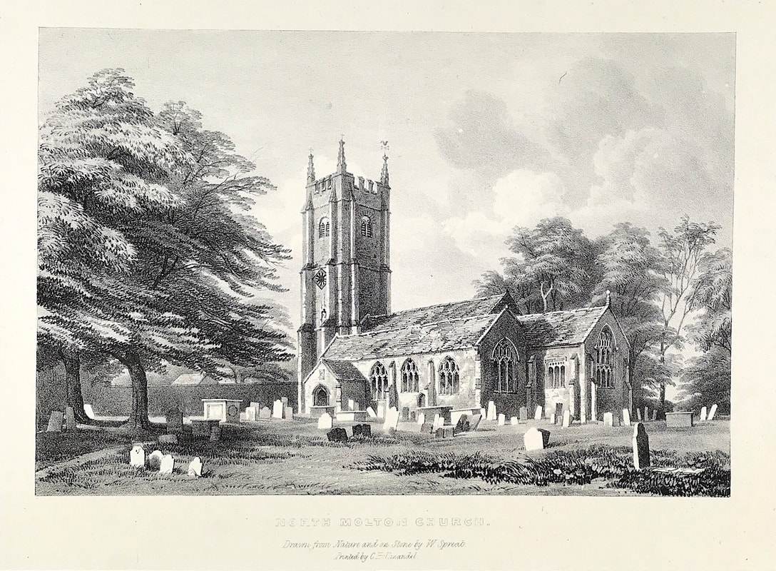 Above: North Molton Church, Drawn on Stone by W. Spreat. Printed by C J Hullmandel for Picturesque Sketches of the Churches of Devon. In the 1840's William Spreat dominated the Exeter scene. One of the earliest of his publications was the "Picturesque sketches of the Churches of Devon" as it records "Drawn from Nature and on Stone. The work was originally published in eighteen parts with 74 lithographs and was completed in 1842. This work contains some of the most beautiful and evocative views of Devonshire capturing the atmosphere of a now long forgotten time. Exceptional engravings include: Sidbury Church, The Old Church at Honiton, Pinhoe Church, Upton Pyne, Cadbury and Chittlehampton Church, just a handful of the seventy four plates. The original lithotints on india paper were laid on a heavier wove paper within the original book. You can see more prints from William Spreats Picturesque Churches of Devon HERE
Old sea charts and nautical maps are another popular theme with map collectors. Early charts and coastline maps provided an essential navigational aid to ships in times past and today these old maps have an appeal to many antique map collectors, especially for those with an interest in sailing. If you have an interest in a particular coastline or your family has a connection with some coastal town, then these maps are great for shedding light on the past history of an area. The example below is a Chart of Delaware Bay and River. Derived from the larger chart of Delaware Bay and River up to Philadelphia Pennsylvania by Joshua Fisher (1707-1783) in 1776. It shows the location of a Pilot's Town near Cape Henlopen. Identifies the ship channels from Cape May and Cape James up the Delaware River past Salem Mass., Wilmington, Newcastle and Chester to the small town of Philadelphia, Pennsylvania. Key features include Mud Island, the Schuylkill River, Stony Point, Egg Island Flats, Fortescues Island, Cold Spring Inlet, Turtle Gut Inlet, and Rehoboth Bay. The mouths of numerous creeks are named including Clark's Ditch, Motherkiln Creek, and Nantuxet Creek. 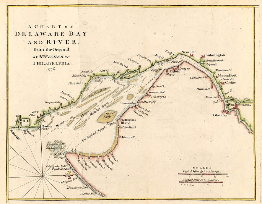 Map of Delaware Bay and River of Philadelphia c1776. After Joshua Fisher Published: July 1779 Published in the "Gentleman's Magazine", July 1779, volume 49, page 369) Joshua Fisher's early chart of Delaware Bay from the Sea-Coast to Reedy-Island was published during the French & Indian War, and was immediately suppressed by the Assembly, fearing that its falling into enemy hands would make Philadelphia a target of the French navy. Fisher's chart showed the lower part of the bay and was intended to be used as a navigational aid for ships sailing toward Philadelphia. In 1775, Fisher produced an expanded chart that showed the bay and the Delaware River to just beyond Philadelphia. This was the most important map of the bay and river in the 18th century. Antique sea charts and nautical maps come up regularly at auctions around the world and often these are accessible online if you have a special place of interest. Even the popular online platforms like Ebay, Amazon and Etsy will give you access to online dealers selling such items. Enjoy the hunt! You can see the full details about this Map of Delaware Bay HERE
Rome today is one of the most important tourist destinations of the world. Perhaps you've had the chance to enjoy some of its archaeological and art treasures, it's a city full of history and offers countless things to see and do. Historic views of Rome with its classical architecture, excavations and surrounding countryside also provide a wealth of interest for print collectors. The work "Corografia dell' Italia" by Giuseppe Orlandini from which the etching below is taken, was possibly the most expensive work ever brought out at the cost to a private individual of 20,000L. It contained a series of Atlases of all Italy. The illustrative portion of the work contains numerous buildings of which no other engravings exist. Parts included: Portions of Italy Lucca and Tuscany, Potifical States, San Marino, Naples & Sicily, the Italian Islands; being the most complete storehouse of information which ever appeared and which no other work can supply. 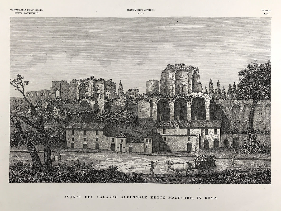 Remains of Palaces built by the Emperors on the Palatine Hill Palazzo Augustale Rome antique etching, print by Orlandini & Parboni c1840. "Avanzi del Palazzo Augustale detto Maggiore in Roma" from Corografia fisica, storica e statistica dell'Italia e delle sue isole by Attilio Zuccagni-Orlandini 1837-1845 (Physical, historical and statistical chorography of Italy and its Islands)Published in Florence Italy c1840. Engraved by Achille Parboni. This view shows the then remains of the Palazzo Augustale in Rome near the Circus Maximus. The remains of Palaces built by the Emperors on the Palatine Hill. The Palatine Hill, which is the centre most of the Seven Hills of Rome, is one of the most ancient parts of the city and has been called "the first nucleus of the Roman Empire." It stands 40 metres above the Roman Forum, looking down upon it on one side, and upon the Circus Maximus on the other. From the time of Augustus Imperial palaces were built here. The term palace, from Old French palais or paleis, stems ultimately from the proper name of Palatine Hill. Giuseppe Orlandini, changed his name to Attilio Zuccagni-Orlandini (Fiesole, 1784 - Florence, 1872). He was an Italian cartographer and geographer. Registered at the registry office as Giuseppe Orlandini he changed his identity to Attilio Zuccagni-Orlandini in memory of his maternal uncle the botanist Attilio Zuccagni, of which he became heir. If you have an interest in historic views of Rome you can see more etchings from Orlandini's "Corografia dell' Italia" HERE
Enjoy! If you're new to collecting antique maps size does matter! Well you may take the view that your budget is the real deciding factor and that does have merit. However new or novice collectors often lack knowledge on the subject so do well to start small. Yes I do mean literally 'small' not just a smaller budget. There's lots of advantages to collecting small. For one thing you don't have a problem with storage space. You can also mount frame and provide wall space easily with a collection of smaller maps, before you decide to go big. IMPORTANT: Also it's less of a shock for your partner when they return home from shopping only to discover that large artwork now taking pride of place on your office wall or even the lounge wall! They then ask "How much did you pay for that thing?" So starting small on most fronts gives you time to find your feet, get a feel for the market and get some experience under your belt, all without spending big! Here's an example of one kind of miniature map. Notice this map carry's big names in the map collectors world even though this is a small map!  Mapmaker: Mercator, G. / Hondius, J. (Cloppenburgh) from " Atlas Minor Gerardi Mercatoris...Ioannis Cloppenburgij, 1630" The fourth and final series of reduced versions of Mercator's atlas was published by the Amsterdam bookseller Johan Cloppenburgh in 1630. Maps engraved by Pieter Van Den Keere. The maps include decorative cartouches, latitudinal and longitudinal lines, coats of arms, compass rose and show political boundaries, cities, towns, topography, vegetation, waterways and landmarks. This is an excellent map of the British Isles and Ireland showing the major cities. Large strap work title cartouche. Blank to Verso (Ref: R W Shirley Early Printed Maps of The British Isles 1477-1650 Revised Edition p 123) Approx engraved area 5.5" X 8" (140mm x 200mm).
There are plenty of maps like this example and others to choose from that fall into the miniature or pocket size category. Maps of the world, country and county maps, town plans, road maps, rivers, planispheres, hemispheres, celestial charts, even geographical playing cards with maps on them, to name a few. As a new collector why not investigate what's available and of interest to you in miniature maps Starting small is never a bad thing. . . .enjoy the hunt. You can find out more about this map HERE If paintings, drawings or prints inspired by the sea interest you then the marine and coastal painter Edward William Cooke is worthy of consideration. He was one of the great marine artists of the 19th century. Born in Pentonville, London, the son of well-known line engraver George Cooke; his uncle, William Bernard Cooke, was also a line engraver of note, and Edward was raised in the company of artists. He was a precocious draughtsman and a skilled engraver from an early age, displayed an equal preference for marine subjects, a specialist in sailing ships and published his "Shipping and Craft" – a series of accomplished engravings – when he was just 18 years of age in 1829. 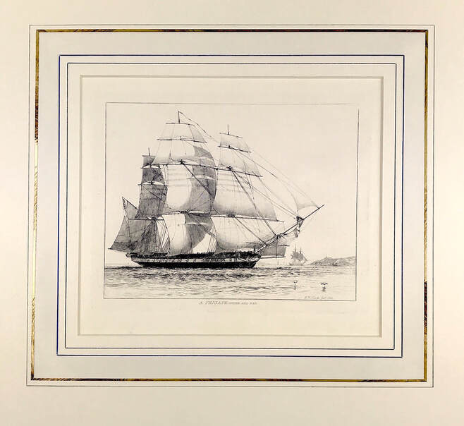 Above: A FRIGATE Under All Sail by marine artist Edward William Cooke from his published work "Fifty Plates of Shipping and Craft Drawn and Etched by Edward Cooke" c1829-31. (Expanded to 65 Plates) Drawn & Etched by William Cooke.
Cooke was "particularly attracted by the Isle of Wight, and on his formative visit of 1835 he made a thorough study of its fishing boats and lobster pots; above all he delighted in the beaches strewn with rocks of various kinds, fishing tackle, breakwaters and small timber-propped jetties." As one of the great marine artists of the 19th century his friends and collaborators included several prominent artists including Clarkson Stanfield, Samuel Prout, Augustus Callcott and John Sell Cotman. Edward William Cooke (27 March 1811 – 4 January 1880). You can see more etched plates from "Fifty Plates of Shipping and Craft " currently in my ETSY Shop catagory Military & Naval including "Mackerel Boats", "Sailing Barges at Battersea", "Prawn Boats at Brighton Beach" and "Lobster Boat at Rottingdean Sussex" As you've probably gathered by now especially if you've read the previous posts in this short series the discussion has been pretty much about the paper, more than the map. In part two we looked at identifying maps produced on wove paper and I hinted that next we would get down to looking at whats on the paper! Well what's on the paper in terms of helping you with identification is a lot, but before we jump into that boat and head upstream there's one other consideration. If you're new to collecting maps its likely you may be interested in maps from anywhere between the 17th century and 20th century. This provides a wide range of possibilities where the majority tend to pitch their collecting tent. Before moving on I'm going to share with you one other area back downstream as it were. You may be interested in starting to collect maps pre 17th century? The very earliest maps are referred to as Manuscript, drawn by hand. Most all early maps and navigational charts were manuscripts, often the work of explorers. This is the place of experts when it comes to authenticity so best advice I can give is, leave it to the experts or certainly get an experts advice if you want to delve into manuscript maps. 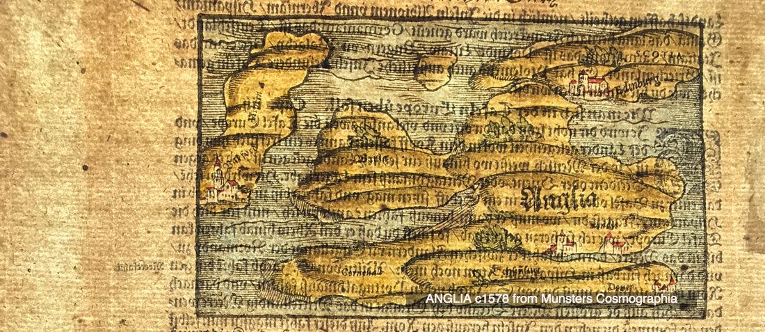 From mid 15th century to late 16th century the earliest printed maps were produced using the Relief printing process. In the map world, relief or woodcut/woodblock maps were common since printing first began. A map could be produced by pressing paper against a raised inked surface that had been carved out on wood. Having carved the image into the wood, ink was rolled onto the raised image, then paper pressed onto the raised area transferring the image to the paper. 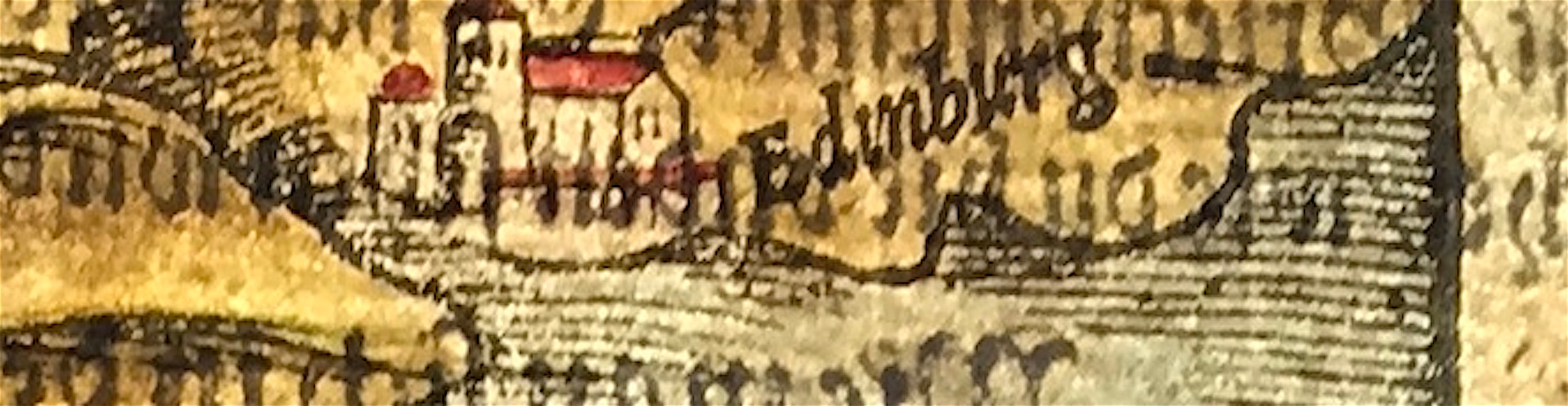 When you look at the examples here, again produced by having a bright light behind the paper you can see in the enlarged image above the typical lines of this kind of printing. The lines are simple, heavy and have blunt ends. The text in woodcut was achieved by inserting movable type as it was easier to make changes. Observe that the paper is laid paper, in keeping with how paper was being produced at the time. Remember the laid lines and chain lines we looked at in Part One? Have fun! Click the link to continue to Part 4 in the Series Collecting Antique Maps You can find this map over on my Etsy shop site: ANGLIA c1578 from Munsters Cosmographia
The work of John Kay is truly original. If you look closely at his miniature portrait work, it will bring a smile to your face. In the example below the attention to detail is second to none and even the horse appears to be smiling! Also the additional fine hand colour makes for a very special collectors print. If you don't know his work I recommend you investigate. John Kay (1742 - 1826) was born near Dalkeith, Midlothian in 1742. The son of a mason, he was apprenticed at the age of thirteen to George Heriot, a barber in Dalkeith. Six years later he moved to Edinburgh where he continued to work as a journeyman barber. In 1771 he was enrolled a member of the Society of Surgeon-Barbers and set up in business on his own account. In his spare time he began to produce highly original portrait sketches and caricatures of Edinburgh characters, despite having no formal training in drawing. He attracted the patronage of William Nisbet of Dirleton, who settled an annuity upon him, and in 1785 was finally able to give up his trade for art. Kay opened a shop in Parliament Close where he sold his etchings and from 1784 - 1822 he is calculated to have etched nearly nine hundred plates portraying many of the most notable Scotsmen of the day. Within twelve years of his death his caricatures were published in a two-volume book, 'A series of original portraits and caricature etchings by the late John Kay', with a second edition following four years later. 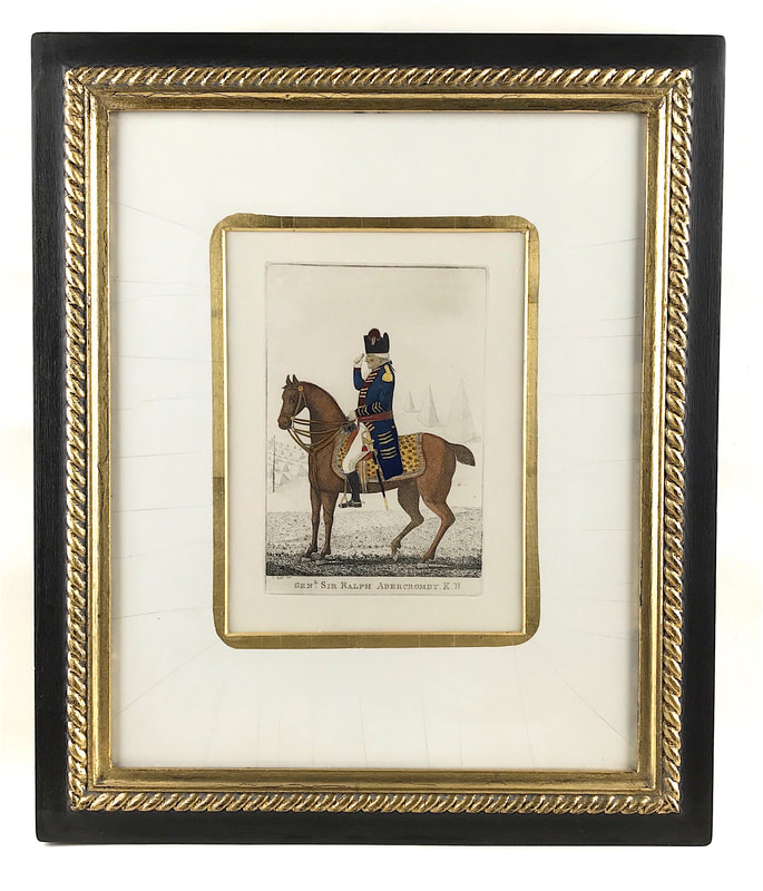 Caricature of General Sir Ralph Abercromby K.B. by John Kay 1801 with gold mount & frame. General Sir Ralph Abercromby K.B Viewing the Army encamped on the plains of Egypt. c1801. Kay's portraits were collected by Hugh Paton and published under the title A series of original portraits and caricature etchings by the late John Kay, with biographical sketches and illustrative anecdotes (Edinburgh, 2 vols. 4to, 1838; 8vo ed., 4 vols., 1842; new 4to ed., with additional plates, 2 vols., 1877), forming a unique record of the social life and popular habits of Edinburgh at its most interesting epoch. Take a look at some more delightful John Kay caricatures HERE Every one is its own little comedy!
The name Arrowsmith is well known in map circles. Arron Arrowsmith (1750-1823) was the founder of one of the leading London map publishing houses in the early nineteenth century. He worked as a surveyor for John Cary, working on various road surveys which appeared in Cary's Travellers Companion in 1790. Having established his own business his reputation became widespread internationally as he specialised in compiling maps recording the discoveries made in different parts of the world. Arrowsmith was also diligent in revising and improving his maps to keep them current, and served as an inspiration for the next generation of surveyors.  When Arron died in 1823 the business and title of Hydrographer to the King passed to his sons, Aaron (1802-1854) and Samuel (1805-1839) who worked as partners from 1823 to 1832, when Aaron resigned to join the church. While the partners never achieved the heights of their father, in addition to reprinting from his stock, they produced numbers of important maps for the Parliamentary Papers, a school atlas, a bible atlas and a series of wall maps of classical history. Samuel died at age 34 in 1839; his brother presided over his funeral. The remaining stock and copper plates were bought at auction by John Arrowsmith, their cousin.
This map is an example from the school atlas: A Comparative Atlas of Ancient And Modern Geography, From original Authorities, and upon a New Plan For The Use Of Eton School, By A. Arrowsmith, Hydrographer to His Majesty. 1828. London, Published by the Author, 10, Soho Square, Sold also by E. Williams, Eton, and at the Eton Warehouse, 10, Red Lion Court, Fleet Street. This edition Published Jany. 2, 1828 by S. Arrowsmith Hydrographer to His Majesty, No. 10, Soho Square. What's your favourite English Country House or Stately Home? Visiting these monuments remains a delight for lovers of history, architecture, formal gardens and the great English landscape. They've starred in everything from period sagas and Jane Austen stories to Star Wars and James Bond thrillers. Maybe you have a favourite? Rare antique engraved birds-eye views of such country houses are significantly important as they show the entire estate, grounds and formal gardens in fine detail and accuracy as they were at that time. Here's an example showing a view of Chipstead Place near Westerham Sevenoaks in Kent c1719 showing the house, gardens and the avenues. 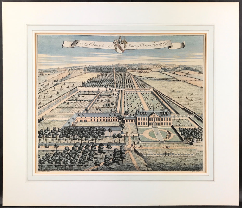 Title: Chepsted Place one of ye Seats of David Polhill Esq.... c1719. Excellent View of Chipstead Place, Kent: T. Badslade Delin. I Kip Sculp. (London: D. Midwinter, 1719.) Copper Engraving, very fine impression.
A delightful bird's eye view of Chepsted Place engraved by Johannes Kip showing the house, gardens and the avenues of trees stretching out into the surrounding park. Engraved by Johannes Kip after Thomas Badeslade for John Harris's 'History of Kent in Five Parts'. The title is on a scroll at the top of the plate, along with Polhill's armorial. David Polhill of Chipstead, Kent, was an English landowner and Whig politician who sat in the House of Commons at various times between 1710 and 1754. He was one of the signatories of the Kentish petition in 1701. Harris was a Doctor of Divinity, author and a Fellow of the Royal Society. For his History, he commissioned Badeslade, an artistically inclined surveyor, to illustrate his work. These drawings were then engraved by Johannes Kip (1652/3-1722), a Dutch draughtsman and engraver who moved to England, and who, together with Leonard Knyff, specialised in engraved views of English country houses. Birds-eye views are popular with print collectors, if you have a favourite Country House or Stately Home these are worth considering for your collection if you can find the antique engraved print. Happy Hunting! You can find out more about this original engraving HERE Chipstead Place If you're new to collecting antique maps one of the first things that confuses the novice is the term 'original map'. This was explained in part one of these posts. I also gave you a basic description of the intaglio print process resulting in the maps image being transferred to the paper. Also in part one I gave you some visual example images of 'laid paper' so you know what you're looking for. As explained all maps were printed on laid paper up until around the end of the 18th century.  As map making entered the start of the 19th century a shift took place towards using paper produced on a new mold called WOVE. This wove paper had been invented by James Whatman in 1757. The development of ‘wove’ paper, producing paper on a smooth, regular-surfaced, woven mesh material that was pioneered by James Whatman at his Turkey Mill in Maidstone, Kent. It resulted in a sheet with a much smoother, less irregular surface than previously found in 'laid' paper 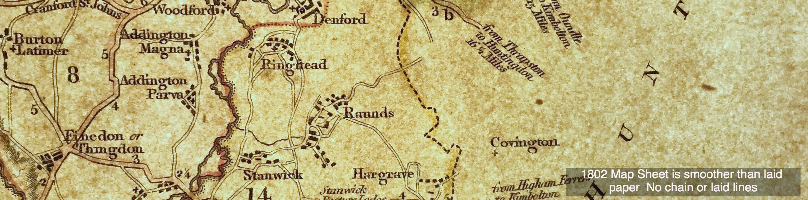 Like many other crafts, paper making by hand on a commercial basis eventually became non viable. The new technique quickly spread throughout Europe and America and soon it dominated the paper making industry. In time machines were developed that made paper on a continuous roll, no more individual sheets! As we entered the first half of the 19th century this wove paper was most common, hence most original maps were produced on wove paper, sometimes watermarked sometimes not. 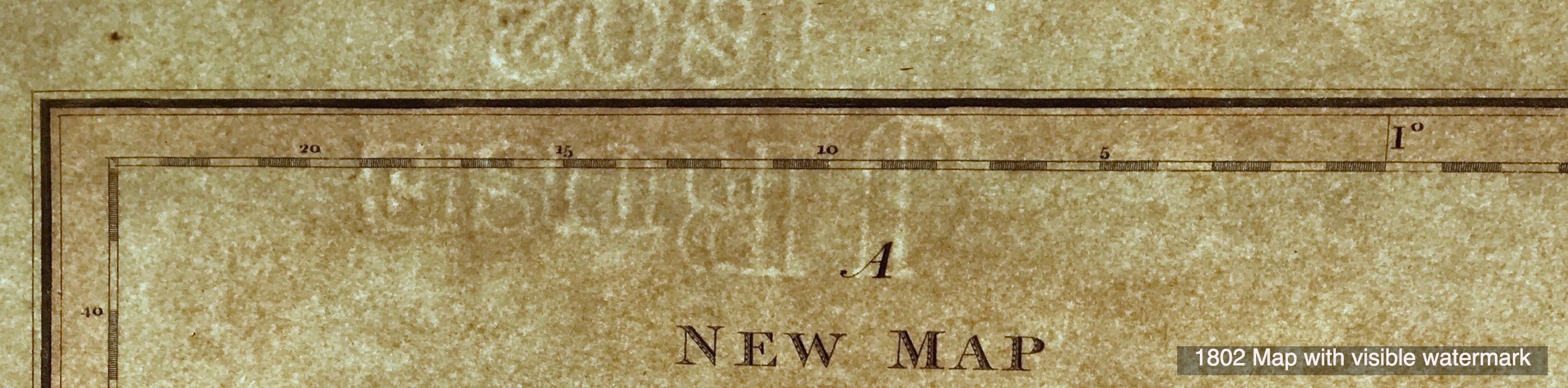 Again the place to start is with the paper but as explained you're now looking for a different set of clues because over time the paper making process changed. The images above are the result of shining a bright light behind the paper. Often it is sufficient to hold the paper up to the light to see the kind of paper the map has been printed on. Getting a little bit of an understanding of this subject is really valuable to you. Being able to recognise paper in this way will help you greatly when it comes to identify if a map is original or a reproduction produced using modern paper processes. In the next post on this subject I'll share with you what to look out for on the paper itself! Click the link to continue to Part 3 in the Series Collecting Antique Maps Please feel free to join the conversation and comment below. . . .
|
LEARN ABOUT MAPS Where to Start? The Paper Earliest Maps Whats on the Paper? Rectum & Recto Marketing Devices Why Changing Faces? What is Ornamentation? Why all those lines? The Embellishment Story Illogical Prices Explained A Reference Library CLICK THE BOOK
Get the FREE Guide!
COLLECTING MAPS
Size Matters! Celestial Maps Strip Road Maps Sea Charts On the River of Life Projections The Sea Monsters Thematic Maps Town Plans Buy with Confidence. . .
More Top Tips for the Novice. Click the book to find out more . . .
COLLECTING PRINTS
Views of River Thames
Views of London Shipping & Craft Meet the Fairies Maritime Naval Military Battles Botanical Historic Churches Historic Views of Rome Archives
May 2024
|