- Published on
Old sea charts and nautical maps are another popular theme with map collectors. Early charts and coastline maps provided an essential navigational aid to ships in times past and today these old maps have an appeal to many antique map collectors, especially for those with an interest in sailing. If you have an interest in a particular coastline or your family has a connection with some coastal town, then these maps are great for shedding light on the past history of an area.
The example below is a Chart of Delaware Bay and River. Derived from the larger chart of Delaware Bay and River up to Philadelphia Pennsylvania by Joshua Fisher (1707-1783) in 1776. It shows the location of a Pilot's Town near Cape Henlopen. Identifies the ship channels from Cape May and Cape James up the Delaware River past Salem Mass., Wilmington, Newcastle and Chester to the small town of Philadelphia, Pennsylvania. Key features include Mud Island, the Schuylkill River, Stony Point, Egg Island Flats, Fortescues Island, Cold Spring Inlet, Turtle Gut Inlet, and Rehoboth Bay. The mouths of numerous creeks are named including Clark's Ditch, Motherkiln Creek, and Nantuxet Creek.
The example below is a Chart of Delaware Bay and River. Derived from the larger chart of Delaware Bay and River up to Philadelphia Pennsylvania by Joshua Fisher (1707-1783) in 1776. It shows the location of a Pilot's Town near Cape Henlopen. Identifies the ship channels from Cape May and Cape James up the Delaware River past Salem Mass., Wilmington, Newcastle and Chester to the small town of Philadelphia, Pennsylvania. Key features include Mud Island, the Schuylkill River, Stony Point, Egg Island Flats, Fortescues Island, Cold Spring Inlet, Turtle Gut Inlet, and Rehoboth Bay. The mouths of numerous creeks are named including Clark's Ditch, Motherkiln Creek, and Nantuxet Creek.
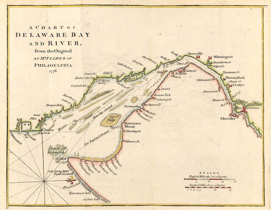
Map of Delaware Bay and River of Philadelphia c1776. After Joshua Fisher Published: July 1779 Published in the "Gentleman's Magazine", July 1779, volume 49, page 369)
Joshua Fisher's early chart of Delaware Bay from the Sea-Coast to Reedy-Island was published during the French & Indian War, and was immediately suppressed by the Assembly, fearing that its falling into enemy hands would make Philadelphia a target of the French navy. Fisher's chart showed the lower part of the bay and was intended to be used as a navigational aid for ships sailing toward Philadelphia. In 1775, Fisher produced an expanded chart that showed the bay and the Delaware River to just beyond Philadelphia. This was the most important map of the bay and river in the 18th century.
Antique sea charts and nautical maps come up regularly at auctions around the world and often these are accessible online if you have a special place of interest. Even the popular online platforms like Ebay, Amazon and Etsy will give you access to online dealers selling such items.
Enjoy the hunt!
You can see the full details about this Map of Delaware Bay HERE
0 Comments

