RARE MAPS AND PRINTS
help@raremapsandprints.co.uk
+44 7788 628706
  • Start Here
  • About
  • Maps
    • British Isles
    • English Counties
    • Road Maps
    • River Thames
    • The Americas
    • Asia to Australia
    • Europe & Middle East
    • World & Hemispheres
    • Sea Charts
    • Military Battle Maps
  • Prints
    • British Topography >
      • Views River Thames
      • Views England
      • Views Wales
      • Views London
    • Satire & Caricature >
      • Vanity Fair Prints
      • Tour of Dr Syntax
      • William Hogarth
      • Max Beerbohm
    • Sporting
    • Amorial
    • Military & Naval
    • Portrait
    • Russian Art
    • Views Italy
  • Engravings
    • Copper
    • Steel
    • Etching
    • Wood Block
    • Lithograph
    • Lithotint
    • Aquatint
    • Photogravure
  • Resources
    • Reference Books
  • Blog
  • The Colourist
  • Contact

Collecting Antique Maps - What Kind of Maps?  More Tips for the Novice!

11/16/2020

Comments

 
​What Kind of antique maps are available to collectors?  In my previous post on the subject I highlighted river maps. Another subject that's collected by map enthusiasts is antique road maps. Way before google was around the Romans produced a pretty accurate map of the fifty thousand or more miles of roads in the Empire in around the third century.  Jump forward in time to the late seventeenth century and sheet maps showing post roads and 'cross-roads' in England and Wales appeared but were limited in detail.  One of the most popular for collectors nowadays first appeared in 1675 with John Ogilby inventing the 'strip map'.
Picture
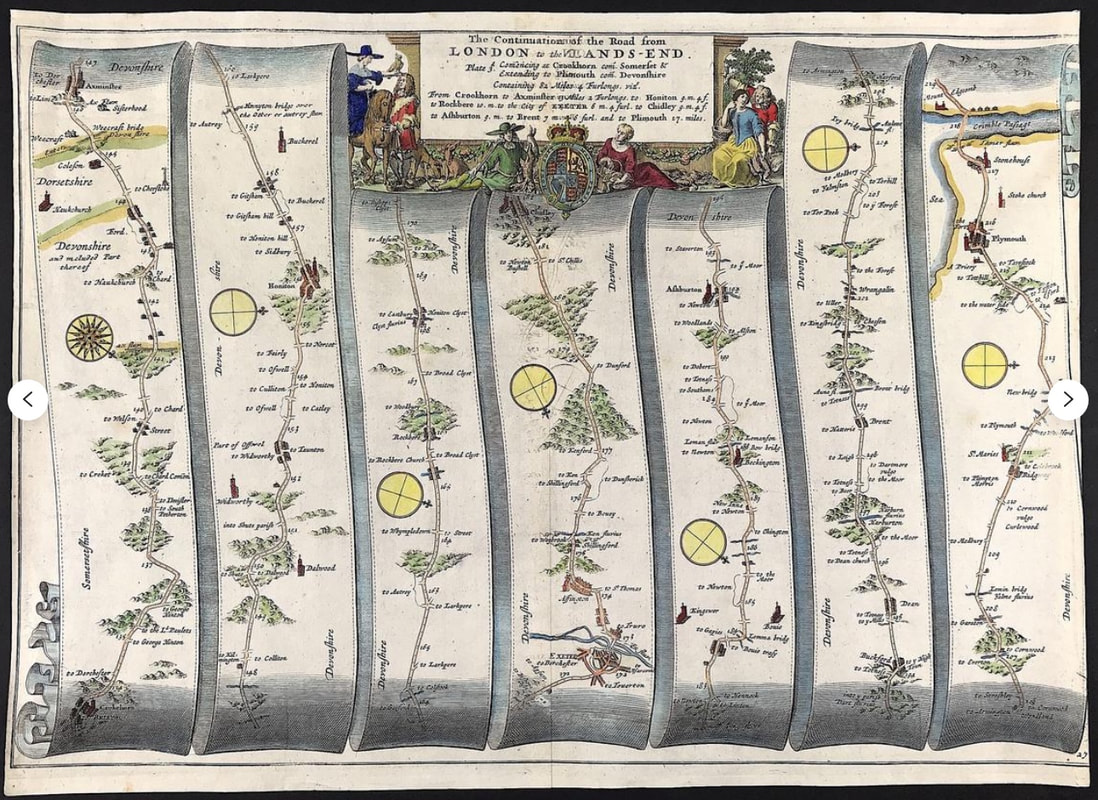
Above: Large Antique Road Map by John Ogilby c1675 'The Continuation of the Road from London to Lands End commencing at Crookham to Axminster to Honiton to Rockbere to the City of Exeter to Chidley to Ashburton to Brent to Plymouth' An original Road Map by John Ogilby being Part 3 (Plate 27) of the Road to Lands End. This part starting at Crookshorn via Axminster, Honiton, Exeter, Ashburton, Buckford through to Plymouth.

Ogilby's Britannia - A Geographical and Historical Description of the Principle Roads thereof, consisted of 100 maps of the principle roads of England and Wales, engraved in strip form. These maps provided details of the roads themselves and descriptive notes of the country on either side.  Each strip had a compass rose to indicate changes in direction.  Ogilby measured over 25,000 miles of roads all surveyed on foot with a 'perambulator' or measuring wheel.  So maybe road maps might be something of interest if you're new to collecting.  There maps are a nice size for displaying framed on a wall the approx sheet size: being about 14" X 20"  and they can often be found in local auctions or like everything for sale online.

Happy Hunting!

You can see more examples of road maps HERE.
Comments

    LEARN ABOUT MAPS

    Where to Start?  
    The Paper  
    Earliest Maps  
    Whats on the Paper? 
    Rectum & Recto  
    Marketing Devices   
    Why Changing Faces?
    What is  Ornamentation?
    Why all those lines?
    The Embellishment Story

    Illogical Prices Explained
    ​A Reference Library
    ​
    CLICK THE BOOK
    Picture
    Get the FREE Guide!
    ​
    ​
    COLLECTING MAPS

    ​Size Matters!

    Celestial Maps
    Strip Road Maps
    Sea Charts
    On the River of Life
    Projections
    The Sea Monsters
    Thematic Maps
    ​Town Plans


    Buy with Confidence. . . 
    Picture
    More Top Tips for the Novice.  Click the book to find out more . . .
    COLLECTING PRINTS
    ​

    Views of River Thames
    Views of London
    Shipping & Craft
    ​Meet the Fairies
    Maritime Naval
    Military Battles
    Botanical 
    Historic Churches
    Historic Views of Rome

    Archives

    July 2021
    June 2021
    May 2021
    April 2021
    March 2021
    February 2021
    January 2021
    December 2020
    November 2020
    October 2020
    September 2020
    March 2020
    November 2019
    June 2019
    May 2019
    April 2019
    March 2019

Contact Info:     
Rare Maps and Prints Limited 
4, Ray House, Cressington Place,
​Bourne End, Bucks SL8 5SL UK 
                             
Kevin J Ryan :     

email: kevin@raremapsandprints.co.uk         
​
Customer Service     
email: help@raremapsandprints.co.uk           
Picture
Member of
​INTERNATIONAL MAP COLLECTORS SOCIETY 


    Maps & Prints Updates

Subscribe to List

Copyright © 2021  -  Rare Maps and Prints Limited  -  Raremapsandprints.co.uk   All Rights Reserved     Site Map     Terms & Conditions     Privacy Policy
  • Start Here
  • About
  • Maps
    • British Isles
    • English Counties
    • Road Maps
    • River Thames
    • The Americas
    • Asia to Australia
    • Europe & Middle East
    • World & Hemispheres
    • Sea Charts
    • Military Battle Maps
  • Prints
    • British Topography >
      • Views River Thames
      • Views England
      • Views Wales
      • Views London
    • Satire & Caricature >
      • Vanity Fair Prints
      • Tour of Dr Syntax
      • William Hogarth
      • Max Beerbohm
    • Sporting
    • Amorial
    • Military & Naval
    • Portrait
    • Russian Art
    • Views Italy
  • Engravings
    • Copper
    • Steel
    • Etching
    • Wood Block
    • Lithograph
    • Lithotint
    • Aquatint
    • Photogravure
  • Resources
    • Reference Books
  • Blog
  • The Colourist
  • Contact

    Join Our List

sign up
SHOP
Home
Shop
About
Updates
Contact
SOCIAL
Facebook
Twitter
Instagram
Proudly powered by Weebly