- Published on
In the last couple of posts I talked about a key feature of most sixteenth to eighteenth century maps the cartouche. There's a handful of other elements that make up a maps ornamentation that you will want to be aware of. Maps were made to different scales so it would be logical for there to be a ratio that compared the measurement on the map to the actual distance. These scales are normally shown by means of multiple scale bars for the units of measurement to the mile.
Another feature is whats known as the 'Legend'. This simple device contains the explanation for symbols used on the map such as towns, roads, canals, rivers, forts, bridges etc. Many old maps have different symbols for the likes of market towns, cathedral towns and fortifications, within some legends there is a simple numbered or alphabetical index.
Another feature is whats known as the 'Legend'. This simple device contains the explanation for symbols used on the map such as towns, roads, canals, rivers, forts, bridges etc. Many old maps have different symbols for the likes of market towns, cathedral towns and fortifications, within some legends there is a simple numbered or alphabetical index.
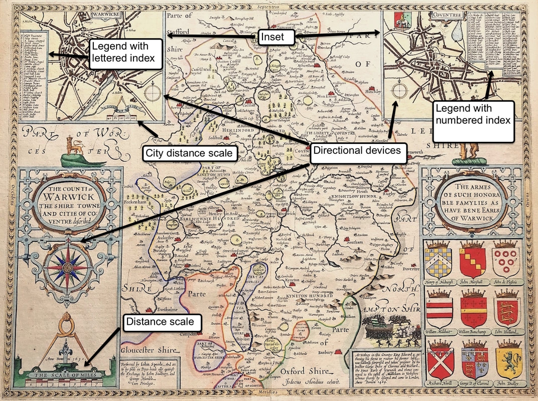
Above: 'THE COUNTI OF WARWICK THE SHIRE TOWNE AND CITIE OF CO:VENTRE descibed' by John Speed c1611
On the John Speed map above you can see on the left a simple legend box within the map inset for the City of Warwick. This has a simple alphabetical index identifying within the street plan certain buildings, streets, lanes, chapels and churches. The inset on the right for the city of Coventry has a similar legend, this time with a numbered index, identifying places and buildings within the city. Notice also that within both of the city insets at the top of the map and the larger cartouche inset on the left there are directional devices. A simple device within the top insets with a more elaborate directional device within the cartouche. In all cases north is indicated by the fleur de lis.
Here's the Benefit?
Getting a basic understanding of a maps anatomy so you're able to identify the ornamental parts that make up a map is essential. This knowledge will arm you with what to look for when it comes to helping you identify an original antique map, plus it may help you decide what type of maps you really want to start collecting.
Click the link to continue to the next article in the Collecting Antique Maps series: "Whats with all those Lines?"
Happy Hunting! Please share your experience and leave a comment below if you found this information helpful . . .
0 Comments

