|
Interest in armed conflict with stories of campaigns and battles and the continuing assessment of leaders, tactics and their strategy remains ever popular with military history enthusiasts, historical reenactment groups and antique print collectors. Here are four of the exceptional aquatint prints from Jenkins The Martial Achievements of Great Britain and Her Allies from 1799 to 1815. Currently available in my May Bank Holiday Sale. The Battle of Quatre Bras 1815, the Battle of Talavera 1809, the Battle of Vimiera 1808 and the Battle of Rolica 1808. Thanks for looking. 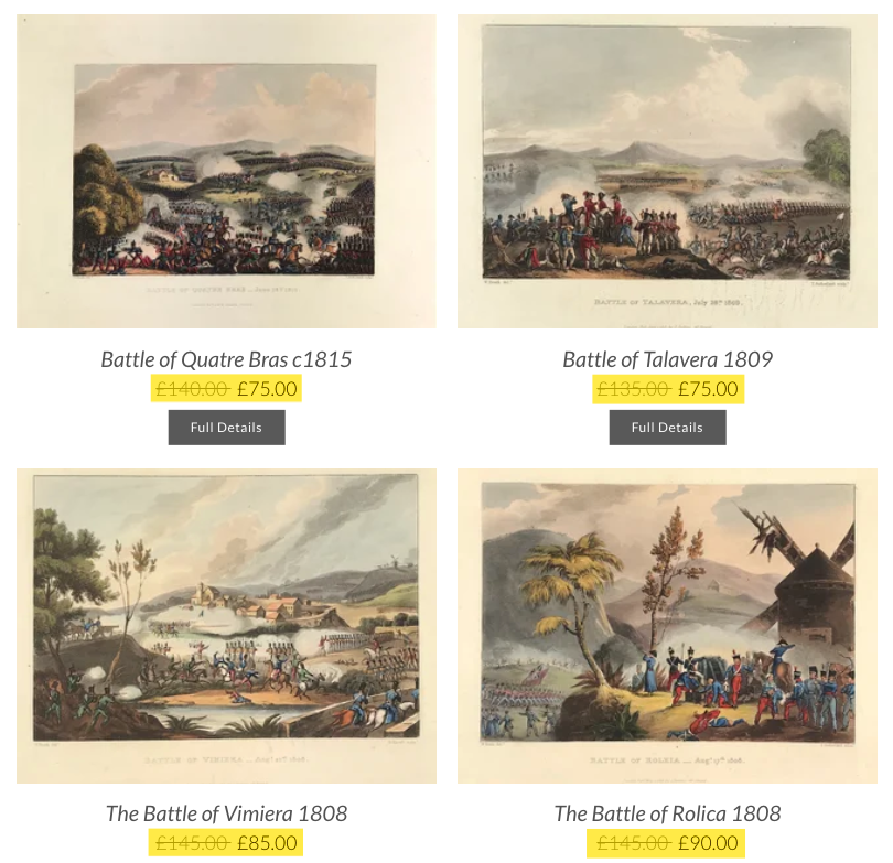 Top Left: The Battle of Quatre Bras was fought on 16 June 1815, as a preliminary engagement to the decisive Battle of Waterloo that occurred two days later. The battle took place near the strategic crossroads of Quatre Bras and was contested between elements of the Duke of Wellington's Anglo-allied army and the left wing of Napoleon Bonaparte's French Armée du Nord under Marshal Michel Ney.
Top Right: The Battle of Talavera was fought just outside the town of Talavera de la Reina, Spain some 120 kilometres southwest of Madrid, during the Peninsular War. At Talavera, an Anglo-Spanish army under Sir Arthur Wellesley combined with a Spanish army under General Cuesta in operations against French-occupied Madrid. Bottom Left: In the Battle of Vimeiro (sometimes shown as "Vimiera" or "Vimeira" in contemporary British texts) on 21 August 1808, the British under General Arthur Wellesley (who later became the Duke of Wellington) defeated the French under Major-General Jean-Andoche Junot near the village of Vimeiro, near Lisbon, Portugal during the Peninsular War. Bottom right: In the Battle of Roliça an Anglo-Portuguese army under Sir Arthur Wellesley defeated an outnumbered Imperial French division under General of Division Henri François Delaborde, near the village of Roliça in Portugal. The French retired in good order. Formerly spelled Roleia in English, it was the first battle fought by the British army during the Peninsular War. For more info on the prints available go HERE Affordable portrait prints remain popular. They tell us something about the subject and about how the subject wanted to be depicted. I regularly have buyers purchase small engraved portraits of eminent personages of. These engravings were engraved from authentic pictures in the galleries of the nobility and public collections of the country. Portraiture is such a vast genre, that there is bound to be something within it that you may like. It could be some historic family connection, military interest or simply an artistic appreciation for the portrait. 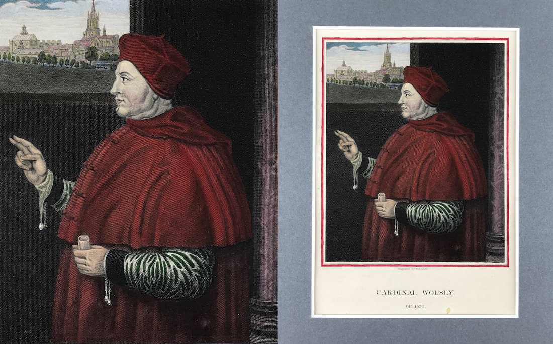 Above: Cardinal Wolsey after the original by Holbein in the collection at Christ Church, Oxford. Here engraved by W.T. Mote with the addition of later fine hand colour. Published: Portraits of Illustrious personages of Great Britain. Engraved from Authentic Pictures in the Galleries of the Nobility and the Public Collections of the Country. Edmund Lodge, Esq. F.S.A. c1835.
Thomas Wolsey was an English archbishop, statesman and a cardinal of the Catholic Church. When Henry VIII became King of England in 1509, Wolsey became the King's almoner. Wolsey's affairs prospered, and by 1514 he had become the controlling figure in virtually all matters of state. Some collectors prefer coloured prints for decorative purposes or to display as they look more attractive coloured. Many people collect engraved prints that have been painted with additional watercolour after the engraving was produced. Because the approach of each water colourist in a sense produces a unique 'new work' its fair to say that the addition of colour gives the buyer a truly unique print. This may well be perfect as a gift or present for a loved one. If you're looking for a particular engraving of a historic personage feel free to drop me an email. Happy Hunting! The above engraved print is set within a 10" x 8" mount ready for framing. You can see more portrait prints HERE. As I've said before on the blog the size of something does not always properly indicate its true value. Often the case when it comes to so called miniature maps. If you're new to collecting. there are some big advantages to collecting small. The wonderful thing about these smaller antique maps is its a good place to start if you're not sure about how you want to move forward with starting a collection. Obviously the rare items will demand a higher price however its an area where many new collectors can get a foothold. A favourite of mine is the work of Alain Mallet a French cartographer and engineer. He started his career as a soldier in the army of Louis XIV, became a Sergeant-Major in the artillery and an Inspector of Fortifications. He also served under the King of Portugal, before returning to France, and his appointment to the court of Louis XIV. 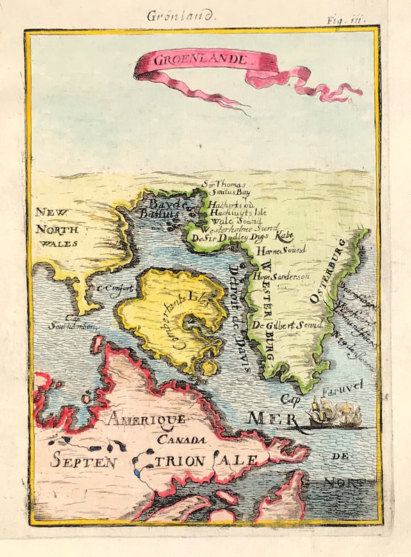 Above: "Groenland" by Alain Manesson Mallet c1683 Greenland, Baffin Bay & Islands, North East Canada, America Coast from Description de L'Univers'.
His five volume work Description de l'univers was originally published in Paris in 1683 and contained almost 700 small engravings of maps, charts, plans and views. The first volume contained many celestial charts and maps others covered Asia, Africa, Europe, America and the British Isles. A year later in 1684 Johann David Zunner also published an edition with French text. Alain Mallet is just one cartographer worth considering when it comes to so called miniature antique maps. Good things do come in small sizes. In some cases rare, collectable, small and valuable considering they are over 340 years old! You can see more miniature antique maps by Alain Mallet in the World & Hemisphere section on this website HERE Another print from Jenkins The Martial Achievements of Great Britain and Her Allies from 1799 to 1815. Below the print is a short excerpt from the original written account as published with the print. Wellington’s victory on 22nd July 1812 over the French army of Marshal Marmont, during the Peninsular War, leading to the re-capture of Madrid; also known as the Battle of Los Arapiles or Les Arapiles. The battle involved: 50,000 British, Portuguese and Spanish troops against 52,000 French troops. Allied losses numbered 3,129 British and 2,038 Portuguese dead or wounded. The Spanish troops took no part in the battle as they were positioned to block French escape routes and suffered just six casualties. The French suffered about 13,000 dead, wounded and captured. As a consequence of Wellington's victory, his army was able to advance to and liberate Madrid for two months, before retreating to Portugal. 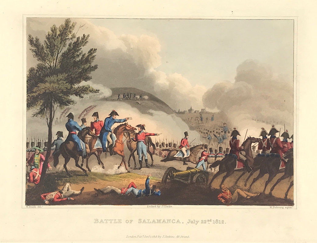 Above: Battle of Salamanca, July 22nd 1812. London Published Jan1st 1815 by J. Jenkins, 48 Strand. From The Martial achievements of Great Britain and Her Allies from 1799 to 1815 by James Jenkins.
Excerpt from the written account as published: MAY 16, 1809. THE annexed illustration represents the allied troops, under the command of the Duke of Wellington, then Sir Arthur Wellesley, in the line of battle in which they were drawn up at the taking of Salamonda. The fore-ground is occupied by the great Lord, a title given by the Portuguese to that illustrious commander; and in this part of the print is also delineated his staff, with some of the artillery employed against that place. The high and encomiastic title of Great Lord, given by a country of rigid Catholics to one whom they conceived to be a heretic, is a striking proof of the effect of splendid talents over the most inveterate prejudice. In this battle the Guards, as appears in the extract from the dispatches annexed, gave another proof of their valour and discipline: but, as the Duke of Wellington has often declared in his dispatches, where all have behaved well, it is invidious to mention any single body. England expected-nor has she been disappointed-every man to do his duty! Extract of a Letter from Sir ARTHUR WELLESLEY, addressed to Lord CASTLEREAGH, dated Monte Alegre, 18th of May, 1809. On the evening of the 14th, I was certain, from the movements of the enemy's detachments, in the neighbourhood of Braga, that he intended to direct his retreat upon Chaves or Monte Alegre; and I directed General Beresford, in case of the latter movement, to push on for Monterey, so as to stop the enenmy if he should pass by Villa de Rey. General Beresford had anticipated my orders to march bis own corps upon Chaves, and had already sent General Silvierra to occupy the passes of Ruivaes and Malgassey, near Salamonda. I arrived at Braga on the 15th (General Murray being at Guimariens, and the enemy about 15 miles in our front), and at Salamonda on the 16th, where we bad an afair with their rear guard. The Guards, under Lieutenant-General Sherbrooke.... How to Identify the Prints: The original prints from The Martial achievements of Great Britain and Her Allies from 1799 to 1815 are aquatint engravings on a medium weight wove paper. Plates also exist that were printed on India Paper. They should clearly identify bottom left W. Heath (delt) who did the drawings and bottom right T. Sutherland (sculpt) who produced most of the aquatint engravings with some by D. Havell, M. Dubourg and J. Hill. Each plate has the date of publication and the name of the publisher beneath the engraved title. The approx engraved area of the plates are 8.5" x 7.75" (215mm x 195mm) including the engraved title text. Engraved plate mark area is approx 8.5 x 11.75 (215mm x 300mm). The large sheet size is approx 11.5" x 14" (290mm x 355mm). You can see more prints from Jenkins The Martial achievements of Great Britain and Her Allies from 1799 to 1815 HERE. If you're interested in a specific print and you cannot see it on my website please feel free to message me.
This can be a real danger when it comes to buying on auction sites like eBay. People ‘watch’ items of interest. If you see an item that you’re interested in you need to be swift about taking action.
The danger is while you're busy ‘not watching’ another buyer gets in and grabs the item you were interested in. You could have simply contacted the seller and asked could you do a deal on a best price offer. While your sitting around watching someone else will be taking action especially if you’ve found a little gem. The reality is we’re all very busy people and “Watching the World Go By” can become a huge waste of time. I favour and recommend taking action quickly. 
Above: This is a quick step by step guide to buying online with practical suggestions and 'real life' examples of what can be achieved. Get your copy today!
If you see an item and it's definitely what you’re after, you’ve checked out the seller and all available information, description, pictures etc, yes all the small print as suggested, then I recommend take action immediately. Approach the seller and politely ask is there a deal to be done. . . .
Since last November I've been sharing with you some of the exceptional aquatint prints from Jenkins The Martial Achievements of Great Britain and Her Allies from 1799 to 1815 and Jenkins The Naval Achievements of Great Britain, From the Year 1793 to 1817. Interest in armed conflict with stories of campaigns and battles and the continuing assessment of leaders, tactics and their strategy remains ever popular with military history enthusiasts, historical reenactment groups and antique print collectors. Closely inked to this interest is a passion for collecting associated military battle plans and maps. Most of these provide military signs and illustrations of fortifications while also providing a knowledge of topographical peculiarities of a country or area to enable a proper understanding of military history. These special 'battle plan' maps are indispensable as such information is simply not available within general geography. 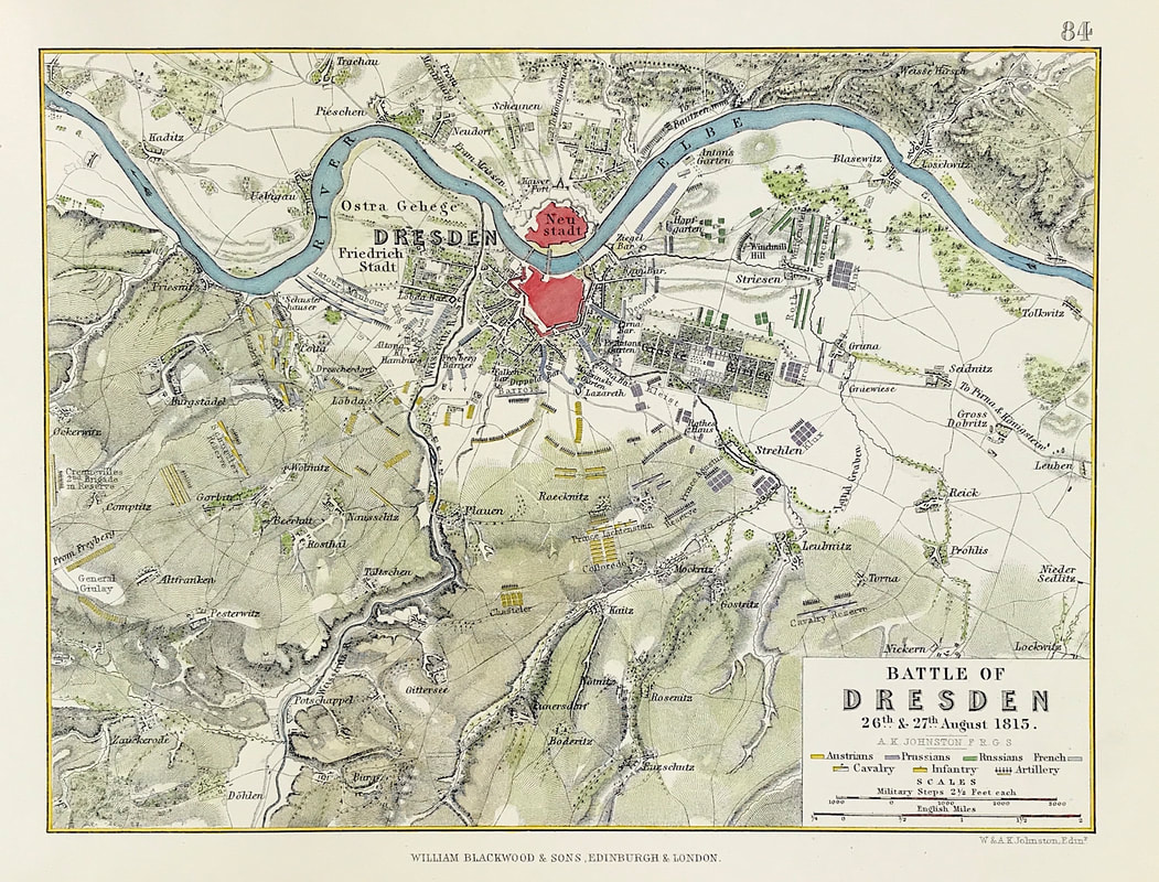 Above: The Battle of Dresden 26th & 27th August 1813, from the Atlas to Alison's History of Europe By Sir Archibald Alison by Alexander Keith Johnson, F.R.S.E F.R.G.S. F.G.S. Published by William Blackwood & Sons, Edinburgh and London c1875. Original map produced with mechanical outline colour. Addition later fine wash hand colour embellishments make this a unique edition of the map.
The Battle of Dresden (26–27 August 1813) was a major engagement of the Napoleonic Wars. The battle took place around the city of Dresden in modern-day Germany. With the recent addition of Austria, the Sixth Coalition felt emboldened in their quest to expel the French from Central Europe. Despite being heavily outnumbered, French forces under Napoleon scored a victory against the Army of Bohemia led by Field Marshal Karl von Schwarzenberg. However, Napoleon's victory did not lead to the collapse of the coalition, and the weather and the uncommitted Russian reserves who formed an effective rear-guard precluded a major pursuit. Three days after the battle, the Allies surrounded and destroyed a French corps advancing into their line of withdrawal at the Battle of Kulm. These maps and plans provide great incite into such military operations and are a valuable source of information to the ever growing number of passionate military collectors. You can see more military battle plans HERE. Happy Hunting! |
LEARN ABOUT MAPS Where to Start? The Paper Earliest Maps Whats on the Paper? Rectum & Recto Marketing Devices Why Changing Faces? What is Ornamentation? Why all those lines? The Embellishment Story Illogical Prices Explained A Reference Library CLICK THE BOOK
Get the FREE Guide!
COLLECTING MAPS
Size Matters! Celestial Maps Strip Road Maps Sea Charts On the River of Life Projections The Sea Monsters Thematic Maps Town Plans Buy with Confidence. . .

More Top Tips for the Novice. Click the book to find out more . . .
COLLECTING PRINTS
Views of River Thames
Views of London Shipping & Craft Meet the Fairies Maritime Naval Military Battles Botanical Historic Churches Historic Views of Rome Archives
May 2024
|