RARE MAPS AND PRINTS
[email protected]
+44 7788 628706
  • About
  • Maps
    • British Isles
    • English Counties
    • Road Maps
    • River Thames
    • The Americas
    • Asia to Australia
    • Europe & Middle East
    • World & Hemispheres
    • Sea Charts
    • Military Battle Maps
  • Prints
    • British Topography >
      • Views England & Scotland
      • Views Wales
      • Views London
      • Views River Thames
    • Sporting
    • Amorial
    • Military & Naval
    • Portrait
    • Russian Art
    • Views Italy
  • Resources
    • Reference Books
  • Blog
  • The Colourist

Collecting Antique Maps - Is it Original or Reproduction Where to start?  Part 2

9/8/2020

Comments

 
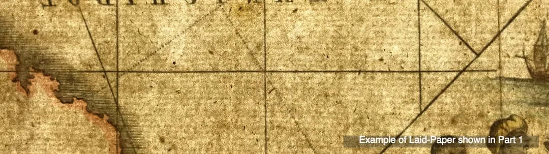
If you're new to collecting antique maps one of the first things that confuses the novice is the term 'original map'. This was explained in part one of these posts. I also gave you a basic description of the intaglio print process resulting in the maps image being transferred to the paper. Also in part one I gave you some visual example images of 'laid paper' so you know what you're looking for.  As explained all maps were printed on laid paper up until around the end of the 18th century.
Picture
As map making entered the start of the 19th century a shift took place towards using paper produced on a new mold called WOVE.  This wove paper had been invented by James Whatman in 1757.  The development of ‘wove’ paper, producing paper on a smooth, regular-surfaced, woven mesh material that was pioneered by James Whatman at his Turkey Mill in Maidstone, Kent. It resulted in a sheet with a much smoother, less irregular surface than previously found in 'laid' paper
Picture
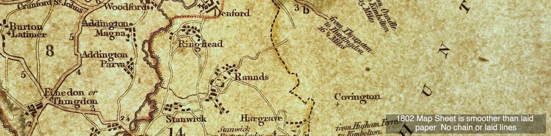
Like many other crafts, paper making by hand on a commercial basis eventually became non viable. The new technique quickly spread throughout Europe and America and soon it dominated the paper making industry. In time machines were developed that made paper on a continuous roll, no more individual sheets!  As we entered the first half of the 19th century this wove paper was most common, hence most original maps were produced on wove paper, sometimes watermarked sometimes not.
Picture
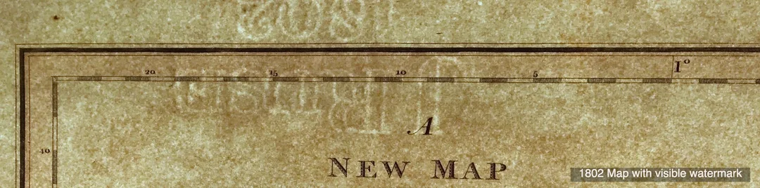
Again the place to start is with the paper but as explained you're now looking for a different set of clues because over time the paper making process changed. The images above are the result of shining a bright light behind the paper.  Often it is sufficient to hold the paper up to the light to see the kind of paper the map has been printed on.  Getting a little bit of an understanding of this subject is really valuable to you.  Being able to recognise paper in this way will help you greatly when it comes to identify if a map is original or a reproduction produced using modern paper processes.

In the next post on this subject I'll share with you what to look out for on the paper itself!  

Click the link to continue to Part 3 in the Series Collecting Antique Maps

Please feel free to join the conversation and comment below. . . . 
Comments

    LEARN ABOUT MAPS

    Where to Start?  
    The Paper  
    Earliest Maps  
    Whats on the Paper? 
    Rectum & Recto  
    Marketing Devices   
    Why Changing Faces?
    What is  Ornamentation?
    Why all those lines?
    The Embellishment Story

    Illogical Prices Explained
    ​A Reference Library
    ​
    CLICK THE BOOK
    Picture
    Get the FREE Guide!
    ​
    ​
    COLLECTING MAPS

    ​Size Matters!

    Celestial Maps
    Strip Road Maps
    Sea Charts
    On the River of Life
    Projections
    The Sea Monsters
    Thematic Maps
    ​Town Plans


    Buy with Confidence. . . 
    Picture
    More Top Tips for the Novice.  Click the book to find out more . . .
    COLLECTING PRINTS
    ​

    Views of River Thames
    Views of London
    Shipping & Craft
    ​Meet the Fairies
    Maritime Naval
    Military Battles
    Botanical 
    Historic Churches
    Historic Views of Rome

    Archives

    May 2024
    October 2023
    November 2022
    September 2022
    August 2022
    July 2022
    November 2021
    July 2021
    June 2021
    May 2021
    April 2021
    March 2021
    February 2021
    January 2021
    December 2020
    November 2020
    October 2020
    September 2020
    March 2020
    November 2019
    June 2019
    May 2019
    April 2019
    March 2019

Contact Info:     
Rare Maps and Prints Limited 
4, Ray House, Cressington Place,
​Bourne End, Bucks SL8 5SL UK 
                             
Kevin J Ryan :     

email: [email protected]         
​
    
          
Picture
Member of
​INTERNATIONAL MAP COLLECTORS SOCIETY 


    Maps & Prints Updates

Subscribe to List

Copyright © 2025 -  Rare Maps and Prints Limited  -  Raremapsandprints.co.uk   All Rights Reserved     Site Map     Terms & Conditions     Privacy Policy
  • About
  • Maps
    • British Isles
    • English Counties
    • Road Maps
    • River Thames
    • The Americas
    • Asia to Australia
    • Europe & Middle East
    • World & Hemispheres
    • Sea Charts
    • Military Battle Maps
  • Prints
    • British Topography >
      • Views England & Scotland
      • Views Wales
      • Views London
      • Views River Thames
    • Sporting
    • Amorial
    • Military & Naval
    • Portrait
    • Russian Art
    • Views Italy
  • Resources
    • Reference Books
  • Blog
  • The Colourist

    Join Our List

sign up
SHOP
Home
Shop
About
Updates
Contact
SOCIAL
Facebook
Twitter
Instagram
Proudly powered by Weebly