RARE MAPS AND PRINTS
help@raremapsandprints.co.uk
+44 7788 628706
  • Start Here
  • About
  • Maps
    • British Isles
    • English Counties
    • Road Maps
    • River Thames
    • The Americas
    • Asia to Australia
    • Europe & Middle East
    • World & Hemispheres
    • Sea Charts
  • Prints
    • British Topography >
      • Views River Thames
      • Views England
      • Views Wales
      • Views London
    • Satire & Caricature >
      • Vanity Fair Prints
      • Tour of Dr Syntax
      • William Hogarth
      • Max Beerbohm
    • Sporting
    • Amorial
    • Military & Naval
    • Russian Art
    • Views Italy
  • Engravings
    • Copper
    • Steel
    • Etching
    • Wood Block
    • Lithograph
    • Lithotint
    • Aquatint
    • Photogravure
  • Resources
  • Blog
  • Contact

Introduction to Pictorial Maps - Recommended Weekend Reading!

5/16/2019

Comments

 
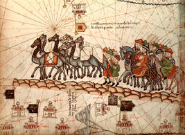
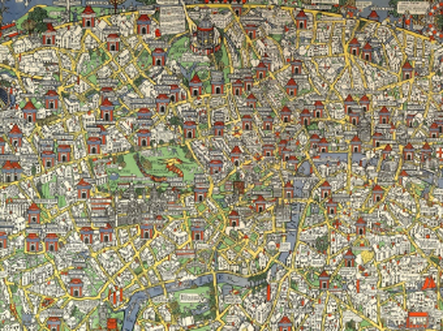
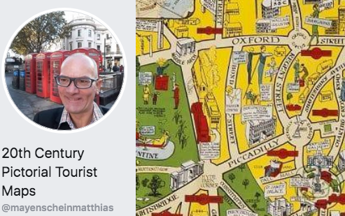
​I've just had the pleasure of reading 'Introduction to Pictorial Maps' by Matthias Mayenschein.  If pictorial maps are of interest to you or a passion as they are for me then you must grab a copy of this work. I've put a link at the bottom of this article.   

The book is a fascinating read. Presenting various maps and mapmakers all in chronological order from Claudius Ptolemy's "Geographia" up to the period of the 1960's then exploring the monumental and pictographic maps.  The most striking maps are presented along with good historic background information.  Many maps are illustrated, needless to say I can only give you a taste here.  Hopefully this will be enough to stimulate your interest and you  an go get a copy for yourself and yes the book  is currently available FREE!
​
The subjects covered and some examples:
1) Pictorial Maps - What are they?
2) The history of pictorial maps, early beginnings with description of the most striking examples
​
​Pictorial maps were drawn since prehistoric times. Some of the wall paintings show maps of hunting areas, streams, routes, and even maps of the stars. Let’s begin this introduction to pictorial maps with the Catalan Atlas from 1375. It is one of the earliest medieval charts, used by marine navigators, containing geographic data from the Hebrew Bible, the famous letters of Prester John, Marco Polo’s records of his travels and other latest information on Asia and China.
​
Image: Marco Polo's caravan traveling along the Silk Road
Picture
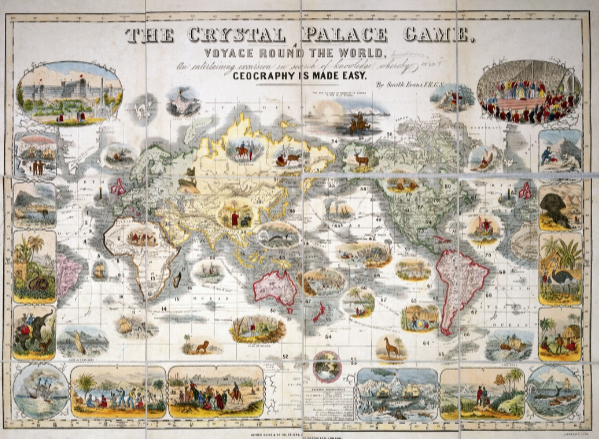
3) Examples of pictorial maps in the 19th century
​
​“The Crystal Palace Game” was created as an educational world map game by the Royal Geographic Society’s Henry Smith Evans around 1854 tocelebrate “The Great Exhibition of the Works of Industry of All Nations”. The brainchild of Prince Albert, consort of Queen Victoria, the exhibition
was held in Hyde Park, in London, between May and October 1851. Players followed a route past sea monsters, hostile tribesmen and other hazards through the distant corners of the British Empire. Intended to celebrate the country’s global dominance and influence in the Arts, Science Technology and Culture, the game board lives up to the motto that proclaims: “Britain, upon whose empire the sun never sets”:
Picture
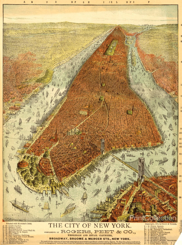
4) The history of pictorial maps, 19th and 20th century, in chronological order, with a description of the most striking examples
​
​A panoramic map or bird’s eye view map was a popular cartographic form to depict U.S. and Canadian cities and towns during the 19th and early 20th century. The development of lithography in the nineteenth century created an opportunity for the development of major new markets for maps, and especially of counties and urban places. Lithography enabled inexpensive, single-sheet reproductions, however in only relatively small numbers.
​
This panoramic promotional bird’s-eye view of Manhattan Island is viewed from New York Harbor in the south and includes the Hudson and East Rivers as well as parts of Brooklyn, Queens and Bergen County and New Jersey on the opposite shores. The buildings and bridges are rendered in what appears to be accurate proportions in the lower part of Manhattan; elsewhere they are
indicated in a more generalised manner. The rivers have numerous clipperships and other vessels sailing the waters or are docked at wharves, with horse-drawn carriages and pedestrians crossing the Brooklyn Bridge.
Picture
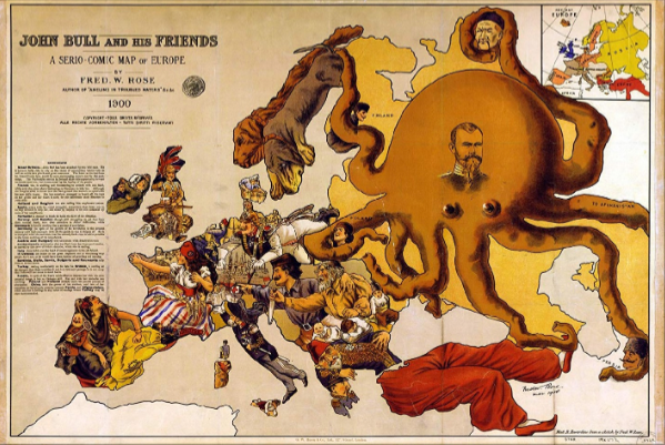
5) Examples of a Paris pictorial / pictographic map
6) Satire & Caricature Maps in the first half of the 20th Century

​The serio-comic political cartoon map of Europe was designed by Frederick Rose and published in 1900. The famous map of Europe made up of caricatures of each country, highlighting the insecurities of the time, as explained by the text on the left. The main worry is the Russian octopus with the face of Tsar Nicolas II, with tentacles wrapped around the throats of Poland, Persia and China, one grabbing for Turkey's foot and another laid across Finland. England and Scotland are depicted as a soldier in tropical uniform, waving a Union Jack, with two wildcats, marked “Orange Free State” and “Transvaa”, savaging his legs. He sits on shells marked with their
destinations: India, Canada, South Africa and Australia. France beckons Germany to help her against Britain who she blames for her colonial upsets, and Italy stretches out a helping hand. Spain is mourning the recent loss of Cuba and the Philippines, her last important colonial possessions.
​
Picture
7) ​The history of pictorial maps from 1914 to 1945, exploring the influential work of MacDonald Gill with descriptions of the most striking examples.
​
​Gill’s 1914 Wonderground Map of Central London managed to match fantasy with accuracy filling this very detailed map with poems, wordplays and satirical commentary on accent, class and social mobility, drawing its inspiration from Lewis Carroll's Alice in Wonderland. The Wonderground Map was a milestone and resurgence of decorative map making that would be copied and developed in America more than a decade later:  Along with the large poster size of the map, perhaps the most immediately striking feature is the brilliant but simple coloration of red, yellow, green and
blue, certain to attract immediate attention. The city is presented in the manner of a medieval walled town, the curved horizon recalling the medieval world map’s enclosing circle, all bounded by a decorative border in which coats of arms evoke a sense of stability and tradition.....
Picture
8) The history of pictorial maps from 1945 to 1960's, exploring monumental & pictographic maps with description of the most striking examples
​

Matthias told me that this started out as a research work inspired by his own love of pictorial maps.  His work on the project continues and you can get an immediate download of "Introduction to Pictorial Maps"  by clicking on this  LINK

You can also find Matthias on Facebook at:
 20th Century Pictorial Tourist Maps 
The Facebook shop offers mostly 20th century pictorial and pictographic (monumental) maps.

You can contact Matthias directly at:
Mayenscheinmatthias@gmail.com

As always if you found this article useful especially id you have only just discovered the fascinating world of pictorial maps please leave a comment below.  I would love to hear from you. . . . 
Picture
Comments

Take a Look at an Extremely Rare Map of South Carolina

5/10/2019

Comments

 
Picture
This very rare copy of A Map of South Carolina and a Part of Georgia published in 1780 by William Faden based on a 1757 version made by the cartographers William Gerard De Brahm and published by Thomas Jefferys has just been acquired by The Colonial Williamsburg Foundation.  Although other copies are known to exist, this example, which is in pristine condition with vibrant original colour, is the first known to have become available in several decades. The large-scale map (about 4½ feet tall by 4 feet wide) is a significantly revised version of the 1757 document by De Brahm, and when paired with this earlier version of the map (a copy already exists in the Colonial Williamsburg collection) the two maps tell a compelling story. Together they show a visual comparison about the extent to which the South Carolinians and Georgians settled the western frontiers of their colonies during the period between the French and Indian War and the American Revolution.  This map is more than just scarce, or the full who, what ,when, why and how you can read the full story HERE

​
A Map of South Carolina and a part of Georgia…, published by William Faden (1750-1836) after William Gerard De Brahm (1718-ca. 1799) after Thomas Jeffreys (ca. 1710-1771), Great Britain, England, London, 1780, black and white line engraving with period hand color on laid paper, in two sheets: top sheet H: 28” x W: 48 ½”, bottom sheet H: 28” x W: 48 ½”, Museum Purchase, 2019-59, A&B Colonial Williamsburg Foundation
​
William Faden was an English cartographer and a publisher of maps. He was the royal geographer to King George III. He replaced Thomas Jefferys in that role. The title of "geographer to the king" was given to various people in the 18th century, including John Senex, Herman Moll, Emmanuel Bowen and Thomas Jeffreys.  If you are a collector of William Faden maps, I'd love to hear from you, please leave a comment below . . . . .
Comments

What do Antique Map Collectors Collect? Just One Thing

5/2/2019

Comments

 
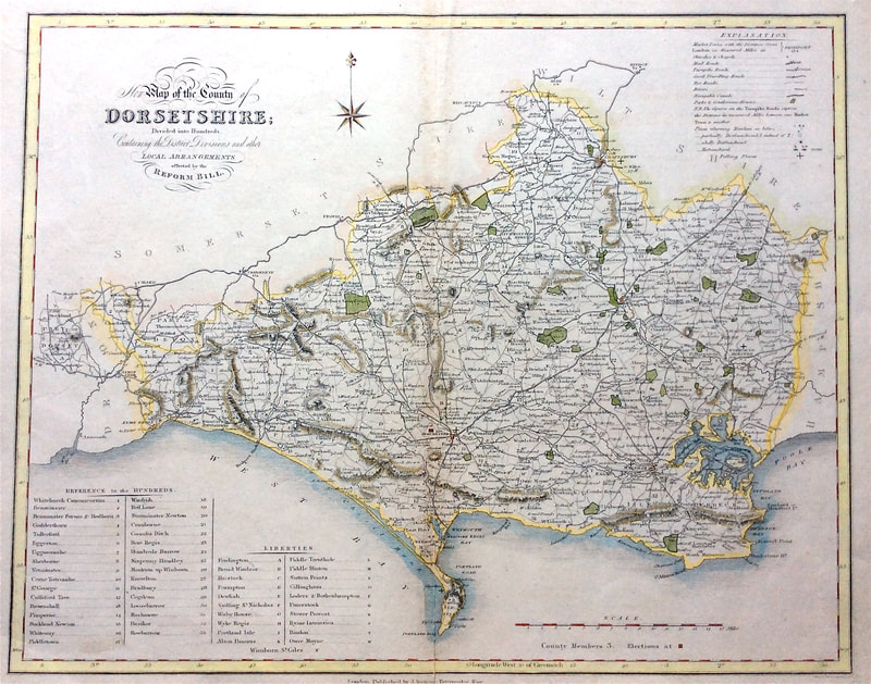
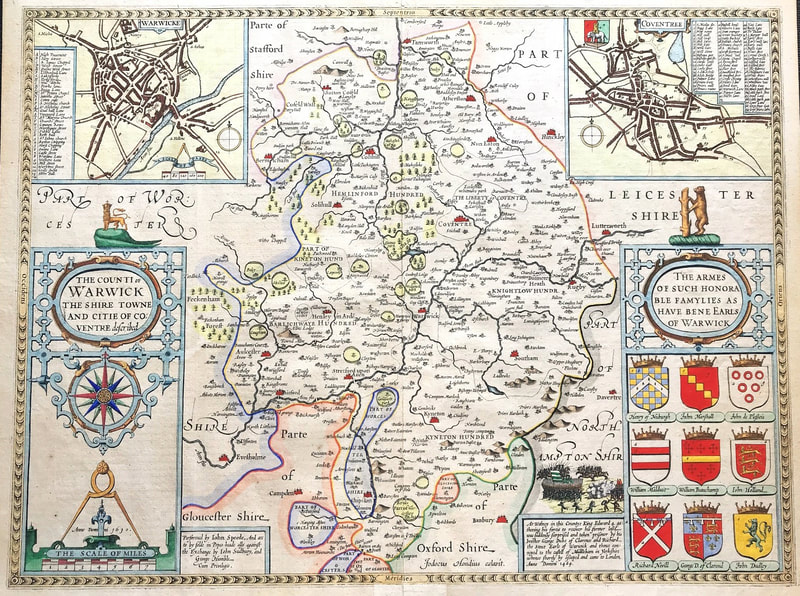
As mentioned before on the blog if you have just a hint of knowledge about the fascinating world of maps you'll appreciate that old maps exist in a vast variety of forms, let alone the many differences in shape, size, subject and appearance.  So it's fair to ask what do collectors collect?  Here’s a quick list of some of the most popular categories of collecting:

1. By area    2. By mapmaker    3. Of a particular period    4. Displaying particular features    5. By theme    6. Individual significance
7. Appearance alone    8. For investment

​All the above have a special reason of interest for collectors as varied as the very collectors themselves. Here are two types of map that map enthusiasts love to collect.
County Map of Dorsetshire by Ebden & Duncan c1833                                          County Map of Warwickshire by John Speed c1611
​
​Just One Thing - By Area

This is one of the most popular geographic themes for collectors.  It allows for a large amount of scope while keeping a limit on the size of a collection and control on cost or the level of investment. 

​You may decide to collect various antique maps of a specific area, like county maps. If you're based in the UK maybe english county maps are of interest to you. Some people collect maps by various mapmakers but only of a specific county.  There will be other maps available about the area also, like road maps, town plans, river maps or some with other cartographic features of interest. 

Collecting rare maps "By Area" is just one thing thats popular with map collectors.  These kinds of maps are readily available in the current market.  If these types of maps are something you already collect I'd love to hear why they interest you?  Please join in the conversation and leave a comment below...
Comments

    Archives

    January 2021
    December 2020
    November 2020
    October 2020
    September 2020
    March 2020
    November 2019
    June 2019
    May 2019
    April 2019
    March 2019

    Categories

    All

    RSS Feed

Contact Info:     
Rare Maps and Prints Limited 
4, Ray House, Cressington Place,
​Bourne End, Bucks SL8 5SL UK 
                             
Kevin J Ryan :     

email: kevin@raremapsandprints.co.uk         
​
Customer Service     
email: help@raremapsandprints.co.uk           
Picture
Member of
​INTERNATIONAL MAP COLLECTORS SOCIETY 


    Maps & Prints Updates

Subscribe to List

Copyright © 2021  -  Rare Maps and Prints Limited  -  Raremapsandprints.co.uk   All Rights Reserved     Site Map     Terms & Conditions     Privacy Policy
  • Start Here
  • About
  • Maps
    • British Isles
    • English Counties
    • Road Maps
    • River Thames
    • The Americas
    • Asia to Australia
    • Europe & Middle East
    • World & Hemispheres
    • Sea Charts
  • Prints
    • British Topography >
      • Views River Thames
      • Views England
      • Views Wales
      • Views London
    • Satire & Caricature >
      • Vanity Fair Prints
      • Tour of Dr Syntax
      • William Hogarth
      • Max Beerbohm
    • Sporting
    • Amorial
    • Military & Naval
    • Russian Art
    • Views Italy
  • Engravings
    • Copper
    • Steel
    • Etching
    • Wood Block
    • Lithograph
    • Lithotint
    • Aquatint
    • Photogravure
  • Resources
  • Blog
  • Contact

    Join Our List

sign up
SHOP
Home
Shop
About
Updates
Contact
SOCIAL
Facebook
Twitter
Instagram
Proudly powered by Weebly