RARE MAPS AND PRINTS
help@raremapsandprints.co.uk
+44 7788 628706
  • Start Here
  • About
  • Maps
    • British Isles
    • English Counties
    • Road Maps
    • River Thames
    • The Americas
    • Asia to Australia
    • Europe & Middle East
    • World & Hemispheres
    • Sea Charts
    • Military Battle Maps
  • Prints
    • British Topography >
      • Views River Thames
      • Views England
      • Views Wales
      • Views London
    • Satire & Caricature >
      • Vanity Fair Prints
      • Tour of Dr Syntax
      • William Hogarth
      • Max Beerbohm
    • Sporting
    • Amorial
    • Military & Naval
    • Portrait
    • Russian Art
    • Views Italy
  • Engravings
    • Copper
    • Steel
    • Etching
    • Wood Block
    • Lithograph
    • Lithotint
    • Aquatint
    • Photogravure
  • Resources
    • Reference Books
  • Blog
  • The Colourist
  • Contact

Take a Look at an Extremely Rare Map of South Carolina

5/10/2019

Comments

 
Picture
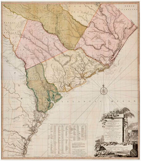
This very rare copy of A Map of South Carolina and a Part of Georgia published in 1780 by William Faden based on a 1757 version made by the cartographers William Gerard De Brahm and published by Thomas Jefferys has just been acquired by The Colonial Williamsburg Foundation.  Although other copies are known to exist, this example, which is in pristine condition with vibrant original colour, is the first known to have become available in several decades. The large-scale map (about 4½ feet tall by 4 feet wide) is a significantly revised version of the 1757 document by De Brahm, and when paired with this earlier version of the map (a copy already exists in the Colonial Williamsburg collection) the two maps tell a compelling story. Together they show a visual comparison about the extent to which the South Carolinians and Georgians settled the western frontiers of their colonies during the period between the French and Indian War and the American Revolution.  This map is more than just scarce, or the full who, what ,when, why and how you can read the full story HERE

​
A Map of South Carolina and a part of Georgia…, published by William Faden (1750-1836) after William Gerard De Brahm (1718-ca. 1799) after Thomas Jeffreys (ca. 1710-1771), Great Britain, England, London, 1780, black and white line engraving with period hand color on laid paper, in two sheets: top sheet H: 28” x W: 48 ½”, bottom sheet H: 28” x W: 48 ½”, Museum Purchase, 2019-59, A&B Colonial Williamsburg Foundation
​
William Faden was an English cartographer and a publisher of maps. He was the royal geographer to King George III. He replaced Thomas Jefferys in that role. The title of "geographer to the king" was given to various people in the 18th century, including John Senex, Herman Moll, Emmanuel Bowen and Thomas Jeffreys.  If you are a collector of William Faden maps, I'd love to hear from you, please leave a comment below . . . . .
Comments

    LEARN ABOUT MAPS

    Where to Start?  
    The Paper  
    Earliest Maps  
    Whats on the Paper? 
    Rectum & Recto  
    Marketing Devices   
    Why Changing Faces?
    What is  Ornamentation?
    Why all those lines?
    The Embellishment Story

    Illogical Prices Explained
    ​A Reference Library
    ​
    CLICK THE BOOK
    Picture
    Get the FREE Guide!
    ​
    ​
    COLLECTING MAPS

    ​Size Matters!

    Celestial Maps
    Strip Road Maps
    Sea Charts
    On the River of Life
    Projections
    The Sea Monsters
    Thematic Maps
    ​Town Plans


    Buy with Confidence. . . 
    Picture
    More Top Tips for the Novice.  Click the book to find out more . . .
    COLLECTING PRINTS
    ​

    Views of River Thames
    Views of London
    Shipping & Craft
    ​Meet the Fairies
    Maritime Naval
    Military Battles
    Botanical 
    Historic Churches
    Historic Views of Rome

    Archives

    July 2021
    June 2021
    May 2021
    April 2021
    March 2021
    February 2021
    January 2021
    December 2020
    November 2020
    October 2020
    September 2020
    March 2020
    November 2019
    June 2019
    May 2019
    April 2019
    March 2019

Contact Info:     
Rare Maps and Prints Limited 
4, Ray House, Cressington Place,
​Bourne End, Bucks SL8 5SL UK 
                             
Kevin J Ryan :     

email: kevin@raremapsandprints.co.uk         
​
Customer Service     
email: help@raremapsandprints.co.uk           
Picture
Member of
​INTERNATIONAL MAP COLLECTORS SOCIETY 


    Maps & Prints Updates

Subscribe to List

Copyright © 2021  -  Rare Maps and Prints Limited  -  Raremapsandprints.co.uk   All Rights Reserved     Site Map     Terms & Conditions     Privacy Policy
  • Start Here
  • About
  • Maps
    • British Isles
    • English Counties
    • Road Maps
    • River Thames
    • The Americas
    • Asia to Australia
    • Europe & Middle East
    • World & Hemispheres
    • Sea Charts
    • Military Battle Maps
  • Prints
    • British Topography >
      • Views River Thames
      • Views England
      • Views Wales
      • Views London
    • Satire & Caricature >
      • Vanity Fair Prints
      • Tour of Dr Syntax
      • William Hogarth
      • Max Beerbohm
    • Sporting
    • Amorial
    • Military & Naval
    • Portrait
    • Russian Art
    • Views Italy
  • Engravings
    • Copper
    • Steel
    • Etching
    • Wood Block
    • Lithograph
    • Lithotint
    • Aquatint
    • Photogravure
  • Resources
    • Reference Books
  • Blog
  • The Colourist
  • Contact

    Join Our List

sign up
SHOP
Home
Shop
About
Updates
Contact
SOCIAL
Facebook
Twitter
Instagram
Proudly powered by Weebly