- Published on
When it comes to getting started with map collecting and specifically English map makers nine times out of ten you'll hear mentioned the names Saxton and Speed. These are certainly popular with new collectors and you will see their English County maps for sale at auction on a regular basis. These names dominate and rightly so however this is really just the tip of the iceberg.
At the beginning of the eighteenth century the Dutch map trade was finally in decline. All through the eighteenth century the work of Saxton and Speed continued to dominate, however a number of other English map makers came on the scene. I'm sure I'll get to share work from all these cartographers with you in future posts but for now lets just take one example Thomas Kitchin.
Kitchin (1719–1784) was a British cartographer, engraver and eventually became a publisher. He was born in Southwark, England, the eldest of several children. He was apprenticed to the map engraver Emanuel Bowen from 1732 to 1739, and he married Bowen’s daughter, Sarah, in December 1739. By 1741 Kitchin was working independently and in 1746 he began taking on apprentices at his firm. His son Thomas Bowen Kitchin was apprenticed to him starting in 1754.
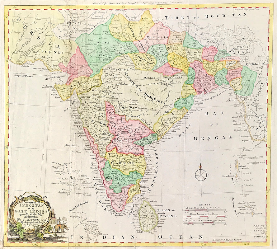
Above: A New Map of Indostan or East Indies agreeable to the latest Authorities c1770 by Thomas Kitchin Geographer & Hydrographer to His Majesty the King. This scarce map of the East indies was published for Millar's New Complete & Universal System of Geography.
By 1755 Kitchin was established in Holborn Hill, where his firm produced all kinds of engraving material, including portraits and caricatures. He married his second wife, Jane, in 1762. Beginning in 1773 Kitchin was referred to as Hydrographer to the King, a position his son also later held. He retired to St. Albans and continued making maps up to the end of his life.
Kitchin produced maps of every sort for magazines and books on history and the antiquities. Many of his maps can be found within the market so as an English map maker he's a good choice for the new collector. The following is a short list of works he produced maps for: The London Magazine (1747-600) Small English Atlas (1749), The Royal English Atlas (1762), Kitchin's Pocket Atlas (1769), Antiquities of England and Wales (1786).
Enjoy the hunt! Please share your own experience so far with map collecting, leave a comment below!
0 Comments

