- Published on
If you’re a newbie to antique maps or at the early stages of building a collection you’ve probably already experienced feelings of confusion or dismay at the outcome of what some maps sell for. Sometimes it just all seems illogical and buying under such circumstances is a real problem.
Truth be told there are many factors that together determine and influence the price of a map. If you just consider how the market itself is made up, it gives you some idea why there is such apparent variation in the antique map market. You have dealers, auctions, serious collectors, casual collectors, institutions and people who simply buy maps as decorative items. All this creates fluctuation in the overall market and there can be a wide price difference for the same map in differing markets.
Why So Much Variation?
You have the simple fact that some maps of certain parts of the world are collected more than others. Then there are the maps that are bought and sold more frequently, which tends to create a relatively narrow more stable price range for these maps. At the other extreme you have scarce or more unusual maps that can sometime demand almost whatever the seller wants when it comes to price.
There really is no one determining factor that sets a maps price and you could easily fill a small book explaining the various issues that should be taken into consideration. I’ll do my best to cover some of these in future posts.
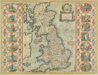
British Isles. Speed (John), Britain as it was devided in the tyme of Englishe Saxons especially during their Heptarchy,published John Sudbury & George Humble, circa 1627, hand coloured engraved map, strapwork cartouche and mileage scale, compass rose and numerous rhumb lines, fourteen historical scenes to vertical margins, 385 x 510mm, English text on verso, framed and double glazed. R.W.Shirley. Early Printed Maps of the British Isles, 1477 - 1650, 317. Estimate: £800 - £1200 SOLD £1550
Get a Fix on the Potential Sale Price
One thing you can do is research online into current and historic price data. A simple way is to take a look at auction sales data. Most auction houses give an estimate on an items potential sale price. Obviously this can be far exceeded on occasion and this is because the market itself decides the value on the day.
Just consider the factors already mentioned above. Who is buying, why are they buying, what are they buying the map for? All will have an affect on what price will be paid. This is why your own research is so important. Keep in mind also, auction houses charge a commission on the purchase price so this must be factored in when buying.
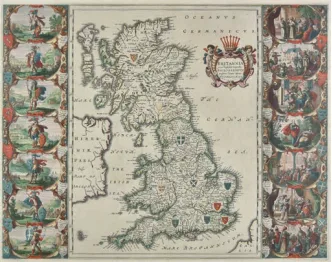
British Isles. Blaeu (Johannes), Britannia prout divisa suit temporibus Anglo-Saxonum praesertim durante illorum Heptarchia, published Amsterdam, circa 1648, engraved map with bright contemporary hand colouring, fourteen historical vignettes to vertical margins, 415 x 530mm, mounted, framed and double glazed, French text on verso R. W. Shirley. Early Printed Maps of the British Isles, 1477 - 1650, 620 (a further issue of 549) Estimate: £600 - £900 SOLD: £1050
The Market Speaks!
The maps shown here are examples of popular maps sold in the last week here in the UK (April 2019). These maps are generally available in the market with the exception of the last map of Yorkshire by Philip Overton. The others are normally found in the possession of most map dealers who sell to the retail market. The prices achieved for these maps at auction are closer to what is known as a 'dealer' price. All would cost you more if you were buying retail from a reputable antique map dealer.
The maps shown here are examples of popular maps sold in the last week here in the UK (April 2019). These maps are generally available in the market with the exception of the last map of Yorkshire by Philip Overton. The others are normally found in the possession of most map dealers who sell to the retail market. The prices achieved for these maps at auction are closer to what is known as a 'dealer' price. All would cost you more if you were buying retail from a reputable antique map dealer.
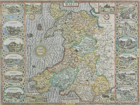
Wales. Speed (John), Wales, John Sudbury & George Humble,[1627], hand coloured engraved map, large compass rose and numerous rhumb lines, four inset vignettes of Bangor, St. Asaph, St. Davids and Llandaff, and twelve oval vignettes of principal towns to vertical margins, small printer’s fold, 385 x 510mm, English text on verso, mounted, framed and double glazed. Estimate: £500 - £800 SOLD: £580
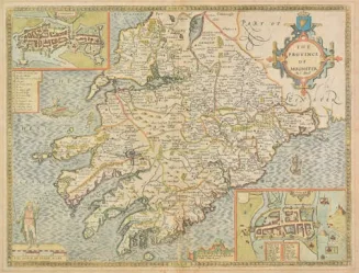
Ireland. Speed (John). The Province of Mounster, Thomas Bassett & Richard Chiswell, [1676], hand coloured engraved map, inset town plans of Cork and Limerick, slight mount staining, central fold partially strengthened on verso, 390 x 510mm, English text on verso. Estimate: £150 - £200 SOLD: £260
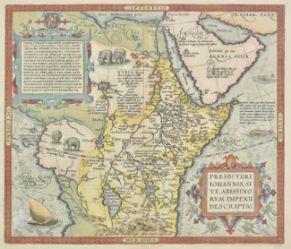
Africa. Ortelius (Abraham), Presbiteri Johannis sive Abissinorum Imperii descriptio, [1598], hand coloured engraved map, large strapwork cartouche, some marginal worming, professionally repaired on verso, 375 x 440mm, French text on verso Marcel van den Broecke. Ortelius Atlas maps, no. 175. Estimate: £300 - £500 SOLD: £360
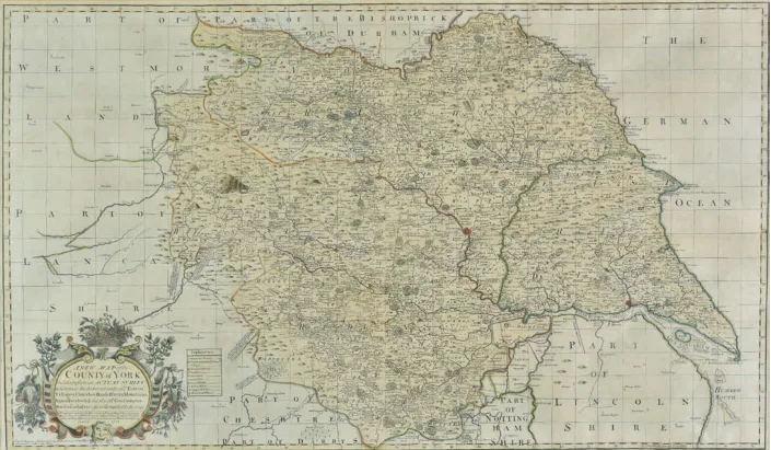
Yorkshire. Overton (Philip & Bowles Thomas, publishers), A New Map of the County of York laid down from an actual survey wherein is included not only all Towns, Villages, Churches, Roads, Rivers, Mountains, Rapes, Hundreds &c. but also all Gentlemen’s Houses & whatever else is remarkable therein, 1728, large hand coloured engraved map on two conjoined sheets, decorative floriate cartouche and table of explanation, 565 x 965mm, mounted, framed and glazed. A close copy of John Warburton’s large scale map of Yorkshire. This map has been recorded in Jean Covens & Corneille Mortier’s ‘Atlas Nouveau contenant Toutes les Parties du Monde...,’ but the lack of any folds in this example suggest that this was published separately. Uncommon, this being only the second copy to appear in auction in the last twelve years. Estimate: £700 - £1000 SOLD: £800
If the maps of John Speed or Johannes Blaeu are of interest to you you can find some English county maps on the site HERE. If you have an interesting map buying experience please tell us about it by leaving a comment below.....
Thanks as always to Dominic Winter Auctions for map images and auction results. More HERE.
0 Comments