- Published on
I really am going to wind this up about the 'kinds of maps' available to newbie collectors. Trouble is I keep thinking of those I missed out! Well another for you is miniature maps. I've collected a few in my time, the example below is from part of an earlier collection I had. The so called miniatures came about for the simple reason that most early atlases were published in folio format and were simply too expensive for most people.
With a market demand for something affordable the smaller atlases came into existence. The maps were based on the large folio maps already produced by various publishers. Understandably these smaller maps do not have the same level of detail as their larger counterparts but they still provide an interesting alternative for collectors. Smaller means, easy to store, less wall space and they can be purchased online with modest shipping costs. Not to be forgotten they will cost you less than the larger folio maps.
With a market demand for something affordable the smaller atlases came into existence. The maps were based on the large folio maps already produced by various publishers. Understandably these smaller maps do not have the same level of detail as their larger counterparts but they still provide an interesting alternative for collectors. Smaller means, easy to store, less wall space and they can be purchased online with modest shipping costs. Not to be forgotten they will cost you less than the larger folio maps.
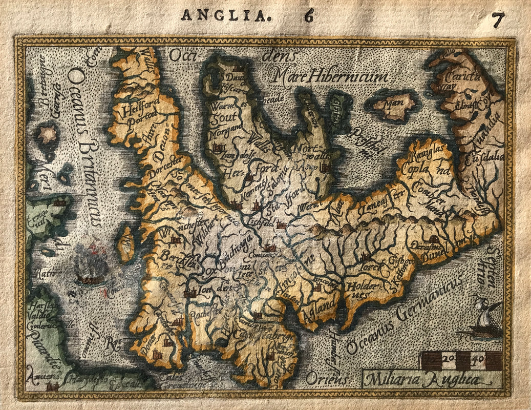
Above: Map ANGLIA by A. Ortelius & P. Galle c1577 Dutch text, British Isles.
Published: Antwerp from Spieghel der Werelit. Pieter Heyns composed the rhyming text which is printed in Dutch on the reverse of the map. Printed by Christopher Plantin. The engraver is unknown. A very rare antique map - Oriented to the West - From the Collection of the late Rodney Shirley. This is the actual map from the Rodney Shirley's collection reproduced in his publication "Early Printed Maps 1477-1650" as Plate 27.
Philip Galle, a publisher friend of Ortelius prepared the maps as reductions from those in Ortelius' atlas. "Galle drew on the Mercator outline of England, Wales and southern Scotland which appeared in the main Ortelius atlas...the map of England and Wales is crowned, with rivers, hills and county names indicated. West is at the top and the narrow border cuts off the tip of Cornwall and Norfolk" (Ref: R. W. Shirley Early Printed Maps of The British Isles 1477-1650 edition 1980 p51)
These so called miniature maps in truth are miniature in name only they tend to be of a size approx 6 x 4 inches. These smaller maps have their own charm and interest, with less availability prices vary and in certain cases will demand a premium however they are well worth seeking out. The so called 'miniatures' may be just right for you.
Happy Hunting!
If you're wondering the map above is no longer available as it was sold to a collector in the USA.
0 Comments