- Published on
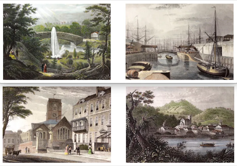
This is just a small example of some of my work on engraved prints as a "colourist" . . . If you are looking to have antique maps or prints coloured get in touch . . . Info Link: https://bit.ly/3CTs2a1
- Published on
Understanding why a map was made, the lack of technologies at the time, how a map fits in with the perceived geography, beliefs, social and cultural realities of a bygone era all has a bearing on how you view such a map today. All these things can influence what maps we are personally attracted to. Mapping of the sky and its celestial bodies within star charts goes all the way back to Ptolemy who is credited with creating the first star catalogue around the year 150. But the Golden Age of celestial cartography is roughly 1600 to 1800. All benefiting from the technological advances in astronomical observations and printing techniques. Many of the most notable star atlases and maps can cost thousands but there are many available at a reasonable price range for the novice collector with a celestial interest.
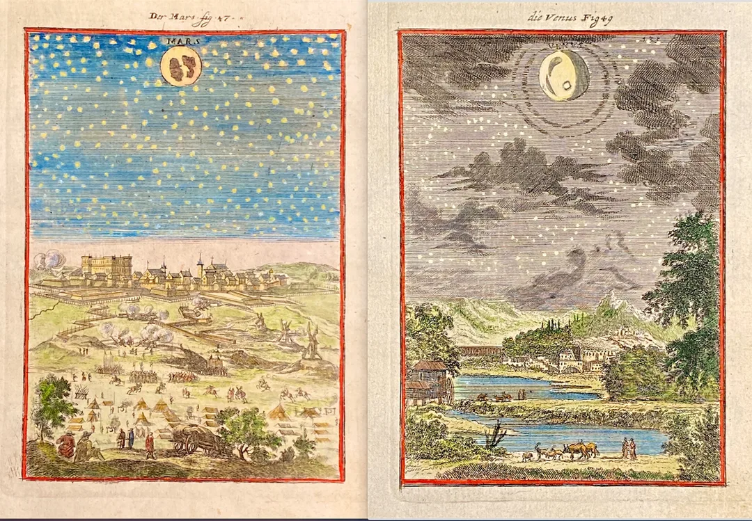
Above: "Mars" and "Venus” from Alain Mallets work Description de l' Univers'. These plates are from Volume 1 of the French text edition published by Johann David Zunner 1684. The plates engraved for Zunner are close copies of the originals and still have French titles and names. A few are signed by there engravers: J.P. Aubrey, Johann J. Vogel and W.C. Daucher.
See More Star Charts
See More Star Charts
- Published on
Stipple engraving is a style of print making that was first used by artists in the 15th century, in the production of fine works that we now term Old Master Prints.The technique most commonly involves the artist scoring their design into a copper print plate by means of a pattern of dots which, when applied to the final print, can convey the effect of shade, tone, or definition.
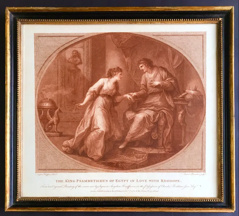
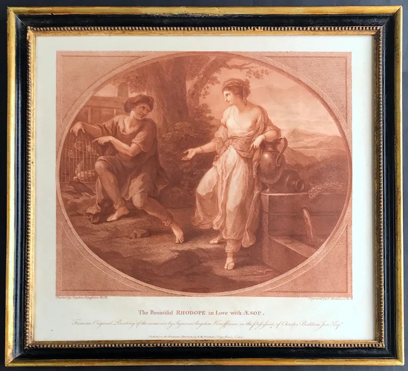
Above: The King Psammetichus of Egypt in Love with Rhodope & The Beautiful Rhodope in Love with Aesop from paintings of the same size by Signora Angelica Kauffman in the Possession of Charles Boddam Jun Esq. Published as the Act Directs 5th Jan 1783 by E. M. Diemar No 377 Strand, London. Bartolozzi was born in Florence but migrated to England, and in 1768 was elected as a founding member of the Royal Academy in London (the RA did not admit engravers at this time but made an exception in his case, getting around the rules by electing Bartolozzi as a painter). He was already hailed as the best engraver in Italy when he met George III's librarian Richard Dalton in 1763. Dalton enticed Bartolozzi to London with a promise of an appointment as engraver to the king. In England he became the most celebrated exponent of the 'stipple' technique whereby he produced prints using dots rather than lines . . . More info: Bartolozzi Prints
- Published on
John Seller, appointed Hydrographer to Charles II in I671, was a maker of mathematical instruments and globes as well as a publisher of marine and terrestrial atlases. His output was considerable and wide-ranging,covering individual charts and maps and complete atlases, but throughout his life he was beset with financial problems which limited the scope of his bigger projects. Of these, the English Pilot, the first part of which successful, but he was able to complete only the first volume without assistance. The details of issue of the later volumes and their subsequent editions are too complicated to be covered here; suffice to say that the work was continued in one form or another for over a century, being issued under many different namesincluding John and Samuel Thornton, W. Fisher, C. Price, Richard and William Mount, Thomas Page and Davidson.
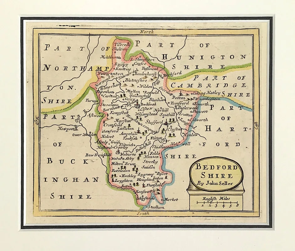
Above: Antique map of Bedfordshire which appeared in John Seller's Anglia Contracta (London: J. Seller, 1694/1695). John Seller (fl. 1660-1697 Engraved area approx: 5" x 6" ( 125mm x 150mm) to plate mark. External mount size: 10.25" X 11" (260mm x 280mm). See Bedfordshire Map
Although the Englisb Pilot was a popular work, Seller used Dutch sources and often actual Dutch copper plates which he adapted for the market by the use of English titles and details. As many of these plates were up to fifty years old their accuracy left much to be desired, a fact which directly inspired the call for a new coastal survey subsequently completed by Captain Greenvile Collins. Later, in 1695, Seller published an Atlas of County Maps, the Anglia Contracta. (Text extract from Antique Maps a Collectors Guide: Moreland C. & David Bannister. Publisher: Phaidon Christie's limited 1989. Antique Maps a Collectors Guide
Although the Englisb Pilot was a popular work, Seller used Dutch sources and often actual Dutch copper plates which he adapted for the market by the use of English titles and details. As many of these plates were up to fifty years old their accuracy left much to be desired, a fact which directly inspired the call for a new coastal survey subsequently completed by Captain Greenvile Collins. Later, in 1695, Seller published an Atlas of County Maps, the Anglia Contracta. (Text extract from Antique Maps a Collectors Guide: Moreland C. & David Bannister. Publisher: Phaidon Christie's limited 1989. Antique Maps a Collectors Guide
- Published on
Another book recommendation for the novice antique map collector. One of the major problems confronting the collector is that of identifying the maps he collects. This is often difficult, for many maps lack the maker's name, the date, the publisher or other helpful detail. Owing to the practices of map publishers in the 16th, 17th and 18th centuries, attributions of a very large number of maps and their identification is today a matter for the expert. In this book Mr Tooley lists and describes nearly 500 maps in such detail as to facilitate identification. He gives the full title, maker's name-often a short biography-size, date, edition or re-issue, significant internal changes and variations. In addition, as an indispensable visual aid to identification the book contains more than 100 full-page reproductions of maps, six in full colour. . .
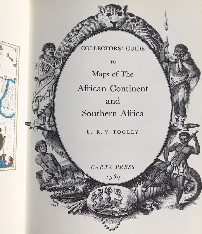
Above: Collectors Guide to Maps of The African Continent and Southern Africa. Tooley R.V. Publisher: Carta Press 1969
Size: 10" x 7.5" (255mm x 190mm). Hardcover. Condition: Good. Dust Jacket Condition: Good.
See more antique maps Reference Books
Size: 10" x 7.5" (255mm x 190mm). Hardcover. Condition: Good. Dust Jacket Condition: Good.
See more antique maps Reference Books
- Published on
The maps of Robert Morden (1611-1703) remain ever popular with collectors of English County Maps. Morden occupied premises in New Cheapside and Cornhill London, where he carried on business under the sign of "The Atlas" as a map, book seller and maker of instruments and globes. Not an outstanding cartographer his work was much critizised, but he produced intertesting sets of geographical playing cards, maps of various parts of the world and as shown below county maps for Camden's Britannica which he is best known for.
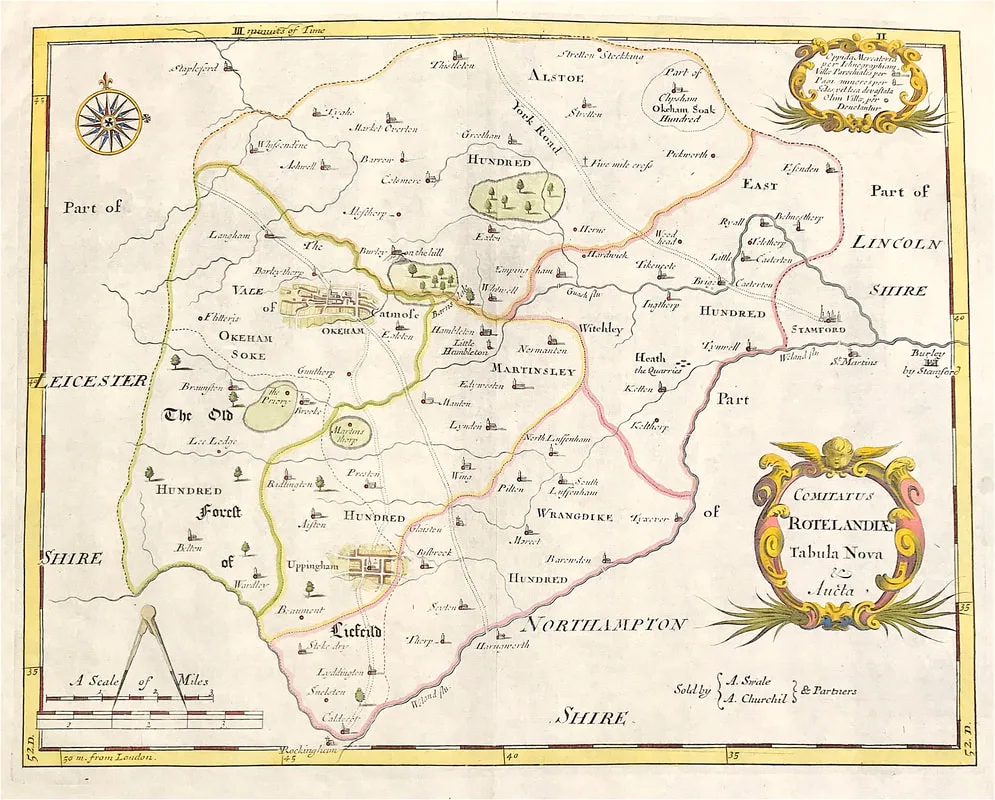
Above: Map of Rutlandshire "Comitatus Rotelandia Tabula Nova & Aucta" by Robert Morden c1722. A finely engraved and detailed map on hand laid paper. Decorative Cartouche. Published in Camden's Britannia by Abel Swale, Awnsham and John Churchill, London. This map comes from ''Camden's Britannia, Newly Translated into English: with large additions and improvements. Translated by Edmund Gibson, Editions 1695 & 1722''
- Published on
Bath - Aquaduct Bridge Claverton c1805. Aquatint and etching with original hand colouring. London, Publish'd 1805 by William Miller, Abermarle Street. Original print on watermarked J. Whatman 1801 wove paper. Superb aquatint by John Hill after the painter and draughtman John Claude Nattes. If you don't know the work of John Hill you really are missing something . . .
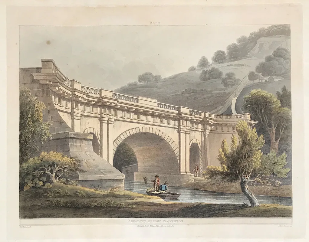
John Hill (1770-1849) began his career as an aquatint engraver of landscapes in his native London, publishing a series of views after the paintings of J.M.W. Turner and others. He immigrated to the U.S. in 1816 and continued engraving for the next 20 years, first in Philadelphia and later in New York. Hill is well known for his pair of New York City prints New York From Weehawk and the companion view New York from Heights near Brooklyn after views by William Guy Wall (1792-1864). He also did the engravings after views by Wall for the Hudson River Portfolio (1821-1825), a set of 20 hand-colored aquatint views along over 200 miles of the Hudson River, from New York City to the Adirondacks. Published by Henry J. Megarey in New York with text by John Agg, the Hudson River prints are considered amongst the finest produced in 19th-century America. Hill is also renowned for his 20 hand colored aquatint views after paintings by Joshua Shaw published between 1820 and 1821 in what is familiarly called The Landscape Album. His son and grandson, John William Hill and John Henry Hill, also became noted landscape painters. More on Aquaduct Bridge Claverton Bath.
- Published on
The wonderful thing about these smaller antique maps is its a good place to start if you're not sure about how you want to move forward with a collection. You can pick up many of these maps very cheaply online. Also they are perfect for the inexpensive gift idea. Obviously even though small the rare items will demand a higher price however its an area where many new collectors can get a foothold.
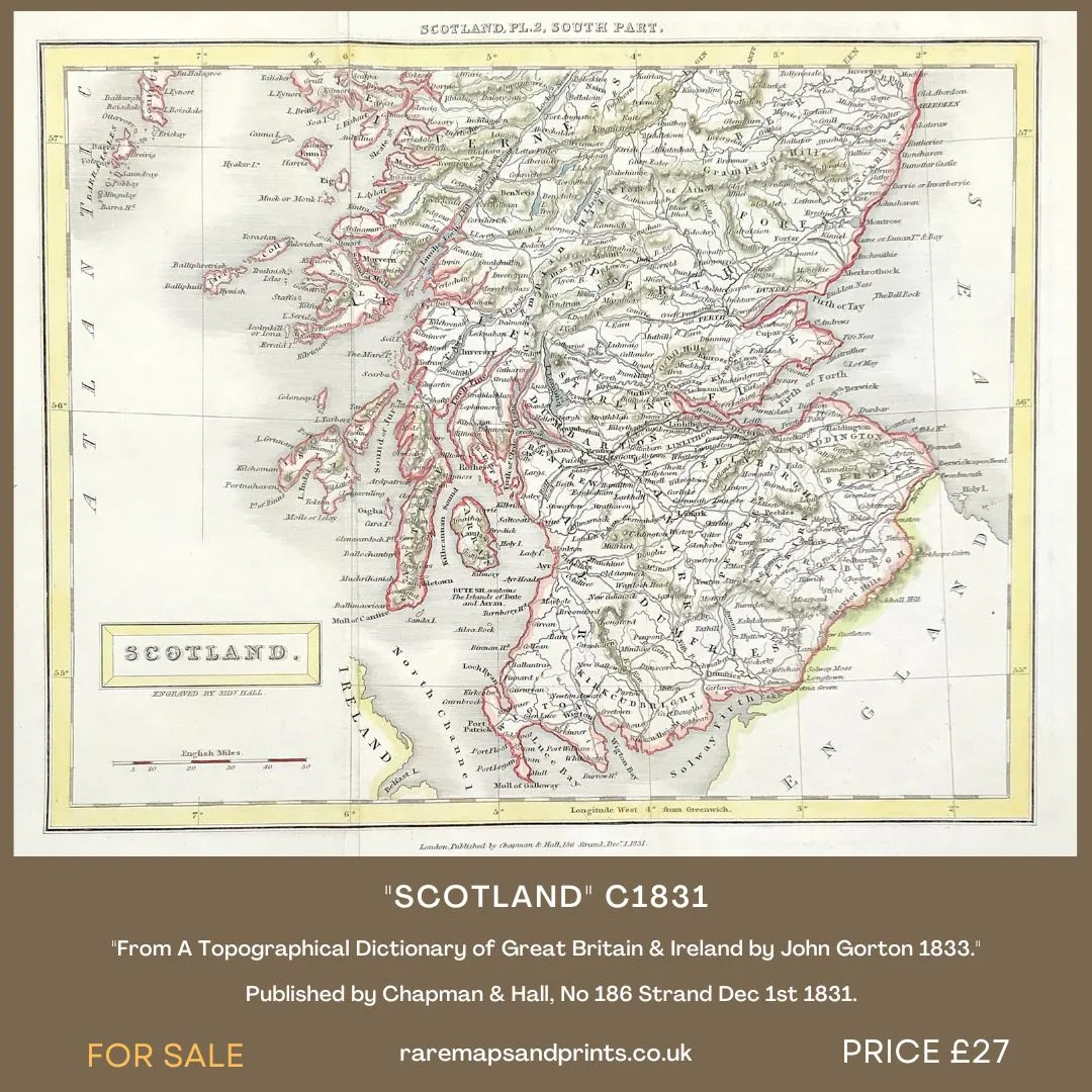
Above: MAP OF SCOTLAND SOUTH PART Pl.2 By Sidney Hall c1831. From A Topographical Dictionary of Great Britain & Ireland by John Gorton 1833. Published by Chapman & Hall, No 186 Strand Dec 1st 1831.
Sidney Hall (1788?–1831) was a British engraver and cartographer well known and popular for his early nineteenth century atlases containing maps of the United Kingdom and of the ancient world reproduced from Hall's engravings. Hall made engravings for a number of international atlases at a time when cartography and atlases were very popular.
John Gorton was an English writer, known as a compiler of reference works. His works include: A translation of Voltaire's Dictionnaire Philosophique, 1824; A General Biographical Dictionary, new edition, with a supplement by Cyrus Redding, bringing the work as far as 1850, in 4 vols. More info on Scotland by Sidney Hall.
- Published on
Another book recommendation for the novice antique map collector. When first published in 1969 by Yale University Press, this Bibliography represented the first attempt to describe the entire known cartographical contribution of the American press prior to 1800 and as such provided an exhaustive and annotated listing of great value to the historian and cartographer. . .
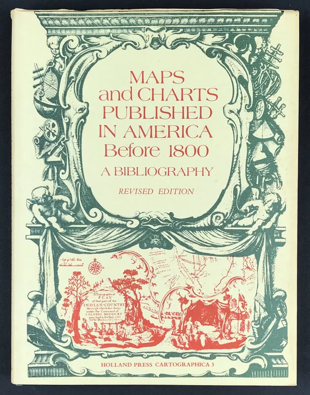
Above; Maps and Charts Published in America Before 1800 A Bibliography - Revised Edition.James Clements Wheat and Christian F. Brun. Publisher: Holland Press Cartographica.3. 1978.The book includes not only the maps and charts published separately but also those used as illustrations in books and pamphlets and from other sources such as atlases, gazetteers, almanacs, and magazines. Intended originally as a descriptive list of American printed maps and charts in the William L. Clements Library of American History, University of Michigan, the project was enlarged to include all such maps located in the original map collections of the United States and Great Britain.
I have a copy of "Maps and Charts Published in America Before 1800" available . . .
I have a copy of "Maps and Charts Published in America Before 1800" available . . .
- Published on
There are so many beautiful places to see in Scotland and if you've never visited the Scottish Highlands I recommend a visit. If you can't make the Highlands the Scottish Boarders have much to offer. Melrose is a small town approximately one hour south of Edinburgh, right in the middle of the Scottish Borders. Melrose Abbey is not only the best-known abbey in the Borders but also the best-preserved one. It is a fine example of Scottish architecture. The view some two hundred years ago can be seen in the print below . . .
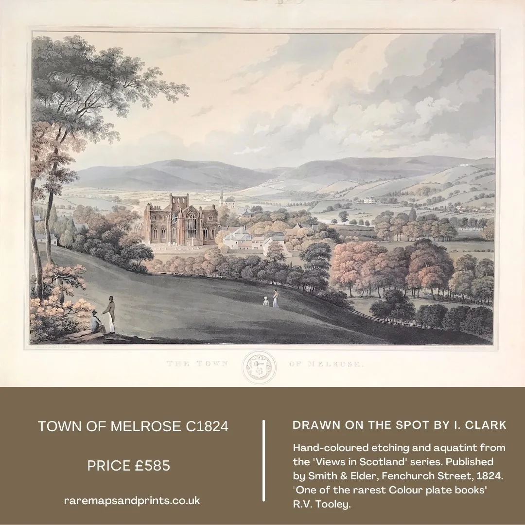
Above: The Town of Melrose. Drawn on the Spot by I. Clark. London, Published by Smith & Elder, Fenchurch Street, 1824. This hand coloured etching and aquatint is from the "Views in Scotland Series". The plates are signed I.Clark but it is generally accepted that these views are the work of the Scottish artist John Heaviside Clark, 1771-1836. He was a prolific artist, aquatinter and engraver, sometimes known as Waterloo Clark due to the sketches he made on the field directly after the Battle of Waterloo. More info on Melrose by Clark.

