RARE MAPS AND PRINTS
[email protected]
+44 7788 628706
  • About
  • Maps
    • British Isles
    • English Counties
    • Road Maps
    • River Thames
    • The Americas
    • Asia to Australia
    • Europe & Middle East
    • World & Hemispheres
    • Sea Charts
    • Military Battle Maps
  • Prints
    • British Topography >
      • Views England & Scotland
      • Views Wales
      • Views London
      • Views River Thames
    • Sporting
    • Amorial
    • Military & Naval
    • Portrait
    • Russian Art
    • Views Italy
  • Resources
    • Reference Books
  • Blog
  • The Colourist

Antique Maps and Map Makers - John Seller

11/25/2022

Comments

 
John Seller, appointed Hydrographer to Charles II in I671, was a maker of mathematical instruments and globes as well as a publisher of marine and terrestrial atlases. His output was considerable and wide-ranging,covering individual charts and maps and complete atlases, but throughout his life he was beset with financial problems which limited the scope of his bigger projects. Of these, the English Pilot, the first part of which successful, but he was able to complete only the first volume without assistance. The details of issue of the later volumes and their subsequent editions are too complicated to be covered here; suffice to say that the work was continued in one form or another for over a century, being issued under many different namesincluding John and Samuel Thornton, W. Fisher, C. Price, Richard and William Mount, Thomas Page and Davidson.
Picture
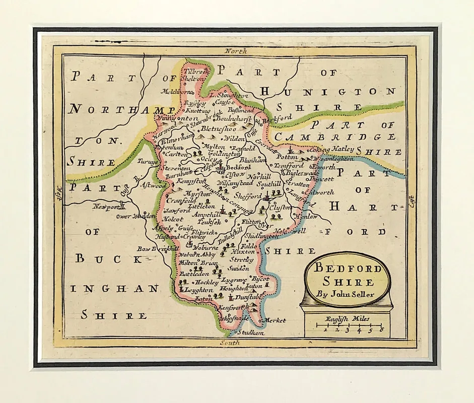
Above: Antique map of Bedfordshire which appeared in John Seller's Anglia Contracta (London: J. Seller, 1694/1695). John Seller (fl. 1660-1697 Engraved area approx: 5" x 6" ( 125mm x 150mm) to plate mark. External mount size: 10.25" X 11" (260mm x 280mm).  See Bedfordshire Map

Although the Englisb Pilot was a popular work, Seller used Dutch sources and often actual Dutch copper plates which he adapted for the market by the use of English titles and details. As many of these plates were up to fifty years old their accuracy left much to be desired, a fact which directly inspired the call for a new coastal survey subsequently completed by Captain Greenvile Collins. Later, in 1695, Seller published an Atlas of County Maps, the Anglia Contracta. (Text extract from Antique Maps a Collectors Guide: Moreland C. & David Bannister. Publisher: Phaidon Christie's limited 1989.  Antique Maps a Collectors Guide

Comments

    LEARN ABOUT MAPS

    Where to Start?  
    The Paper  
    Earliest Maps  
    Whats on the Paper? 
    Rectum & Recto  
    Marketing Devices   
    Why Changing Faces?
    What is  Ornamentation?
    Why all those lines?
    The Embellishment Story

    Illogical Prices Explained
    ​A Reference Library
    ​
    CLICK THE BOOK
    Picture
    Get the FREE Guide!
    ​
    ​
    COLLECTING MAPS

    ​Size Matters!

    Celestial Maps
    Strip Road Maps
    Sea Charts
    On the River of Life
    Projections
    The Sea Monsters
    Thematic Maps
    ​Town Plans


    Buy with Confidence. . . 
    Picture
    More Top Tips for the Novice.  Click the book to find out more . . .
    COLLECTING PRINTS
    ​

    Views of River Thames
    Views of London
    Shipping & Craft
    ​Meet the Fairies
    Maritime Naval
    Military Battles
    Botanical 
    Historic Churches
    Historic Views of Rome

    Archives

    May 2024
    October 2023
    November 2022
    September 2022
    August 2022
    July 2022
    November 2021
    July 2021
    June 2021
    May 2021
    April 2021
    March 2021
    February 2021
    January 2021
    December 2020
    November 2020
    October 2020
    September 2020
    March 2020
    November 2019
    June 2019
    May 2019
    April 2019
    March 2019

Contact Info:     
Rare Maps and Prints Limited 
4, Ray House, Cressington Place,
​Bourne End, Bucks SL8 5SL UK 
                             
Kevin J Ryan :     

email: [email protected]         
​
    
          
Picture
Member of
​INTERNATIONAL MAP COLLECTORS SOCIETY 


    Maps & Prints Updates

Subscribe to List

Copyright © 2025 -  Rare Maps and Prints Limited  -  Raremapsandprints.co.uk   All Rights Reserved     Site Map     Terms & Conditions     Privacy Policy
  • About
  • Maps
    • British Isles
    • English Counties
    • Road Maps
    • River Thames
    • The Americas
    • Asia to Australia
    • Europe & Middle East
    • World & Hemispheres
    • Sea Charts
    • Military Battle Maps
  • Prints
    • British Topography >
      • Views England & Scotland
      • Views Wales
      • Views London
      • Views River Thames
    • Sporting
    • Amorial
    • Military & Naval
    • Portrait
    • Russian Art
    • Views Italy
  • Resources
    • Reference Books
  • Blog
  • The Colourist

    Join Our List

sign up
SHOP
Home
Shop
About
Updates
Contact
SOCIAL
Facebook
Twitter
Instagram
Proudly powered by Weebly