- Published on
Back on my "More Tips for the Novice" theme its fair to say the eighteenth century has much to offer the map collecting enthusiast. Much of the world's cartography was still unmapped at the beginning of the century and the existence of an Antarctic continent was not known, while much of the Pacific remained undiscovered by Europeans until the end of the century.
As the century advanced there was a resurgence in Germany in map publishing with the firms of Homann, Seutter and Lotter. Matthäus Seutter (1678-1757) was one of the most important and prolific German mapmakers who began his career apprenticed as an engraver with J.B. Homann. Sometime in the early 18th century Seutter left Homann to establish his own independent cartographic publishing firm in Augsburg. Though he struggled in the early years of his independence, Seutter’s engraving skill and commitment to diversified map production eventually gained him a substantial following. In 1732 he was honoured by the German Emperor Charles VI with the title of “Imperial Geographer”. His most famous work is Atlas Novus Sive Tabulae Geographicae, published in two volumes ca. 1730.
As the century advanced there was a resurgence in Germany in map publishing with the firms of Homann, Seutter and Lotter. Matthäus Seutter (1678-1757) was one of the most important and prolific German mapmakers who began his career apprenticed as an engraver with J.B. Homann. Sometime in the early 18th century Seutter left Homann to establish his own independent cartographic publishing firm in Augsburg. Though he struggled in the early years of his independence, Seutter’s engraving skill and commitment to diversified map production eventually gained him a substantial following. In 1732 he was honoured by the German Emperor Charles VI with the title of “Imperial Geographer”. His most famous work is Atlas Novus Sive Tabulae Geographicae, published in two volumes ca. 1730.
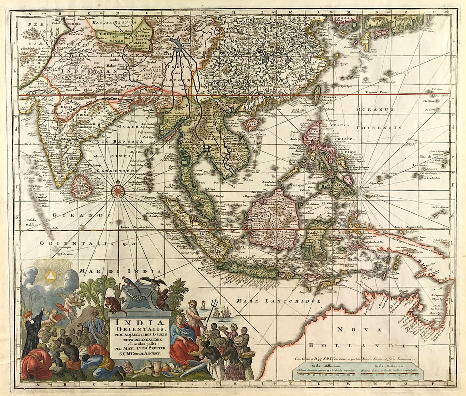
Above: Matthäus Seutter, India Orientalis cum Adjacentibus Insulis Nova Delineatione ob oculos posita . . c1730/42
This is a nice example of Seutter's scarce map of the East Indies and part of Australia, from the Atlas Novus. The map extends from Japan and Persia in the North, to the Maldives and Australia and the Ladrones in the South and West. One of the most notable features of the map is that Australia continues to be attached to Nova Guinea, albeit with some hesitation, as the image extends outside the inner neatline to convey this information - this in spite of the fact that there are 20 or more place names along Australia's Northern Coastline. The detail throughout Southeast Asia is excellent and the print style typically strong. The cartouche is one of the more ornate Seutter cartouches, with elaborate scenes from sea, land, jungle and mythology .
This map is currently up for sale at a reduced price as part of my "Mad as a March Hare" Sale. More information HERE
0 Comments