RARE MAPS AND PRINTS
[email protected]
+44 7788 628706
  • About
  • Maps
    • British Isles
    • English Counties
    • Road Maps
    • River Thames
    • The Americas
    • Asia to Australia
    • Europe & Middle East
    • World & Hemispheres
    • Sea Charts
    • Military Battle Maps
  • Prints
    • British Topography >
      • Views England & Scotland
      • Views Wales
      • Views London
      • Views River Thames
    • Sporting
    • Amorial
    • Military & Naval
    • Portrait
    • Russian Art
    • Views Italy
  • Resources
    • Reference Books
  • Blog
  • The Colourist

Collecting Antique Maps - Thematic Cartography

8/17/2022

Comments

 
The range of thematic maps is just about unlimited and generally cover physical, political, economic and social aspects connected with a specific geographical area.  If geography and especially mountain ranges and forests are of interest to you then the map below by Heinrich Scherer is for you. Scherer’s world atlas, the Atlas Novus, first published in Munich between 1702 and 1710 and reissued in a second edition between 1730 and 1737, forms a singularly unusual, almost revolutionary work in terms of the development of European mapmaking at the beginning of the 18th Century. The Atlas comprised seven separate volumes entitled Geographia Naturalis, Geographia Hierarchica, Geographia Politica, Tabellae Geographicae, Atlas Marianus, Critica Quadrapartita, and Geographia Artificialis. Most of the some 180 maps appear to have been prepared between 1699 and 1700 and were engraved by Leonard Hecknaeur, Joseph Montelegre or Matthus Wolfgang, with each volume introduced by fine allegorical frontispieces by the same engravers . . .
Picture
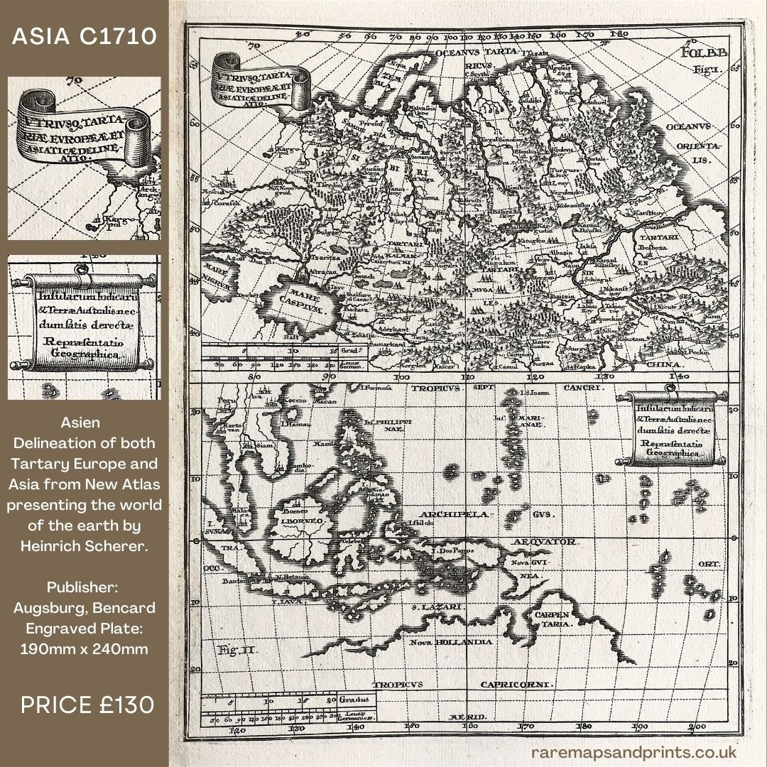
Above:  Asien - Utriusque Tartariae, Europaeae et Asiatiae delinatio. Insularum Indicarum & Terre Australis. Kupferstich aus Scherer, Heinrich: Atlas Novus exhibens orbem terraqueum (Asien - Delineation of both Tartary, Europe and Asia. of the Indian Islands & Southern Land).Scherer takes thematic cartography one step further in the Geographia Politica and Geographia Naturalis. He produces maps that remove political boundaries, borders and place names, replacing them with the revolutionary concept for the period of showing the mountains and forests in physical relief with all of the major waterways and rivers systems clearly depicted. Details on Heinrich Scherer - Map of Asia
Comments

    LEARN ABOUT MAPS

    Where to Start?  
    The Paper  
    Earliest Maps  
    Whats on the Paper? 
    Rectum & Recto  
    Marketing Devices   
    Why Changing Faces?
    What is  Ornamentation?
    Why all those lines?
    The Embellishment Story

    Illogical Prices Explained
    ​A Reference Library
    ​
    CLICK THE BOOK
    Picture
    Get the FREE Guide!
    ​
    ​
    COLLECTING MAPS

    ​Size Matters!

    Celestial Maps
    Strip Road Maps
    Sea Charts
    On the River of Life
    Projections
    The Sea Monsters
    Thematic Maps
    ​Town Plans


    Buy with Confidence. . . 
    Picture
    More Top Tips for the Novice.  Click the book to find out more . . .
    COLLECTING PRINTS
    ​

    Views of River Thames
    Views of London
    Shipping & Craft
    ​Meet the Fairies
    Maritime Naval
    Military Battles
    Botanical 
    Historic Churches
    Historic Views of Rome

    Archives

    May 2024
    October 2023
    November 2022
    September 2022
    August 2022
    July 2022
    November 2021
    July 2021
    June 2021
    May 2021
    April 2021
    March 2021
    February 2021
    January 2021
    December 2020
    November 2020
    October 2020
    September 2020
    March 2020
    November 2019
    June 2019
    May 2019
    April 2019
    March 2019

Contact Info:     
Rare Maps and Prints Limited 
4, Ray House, Cressington Place,
​Bourne End, Bucks SL8 5SL UK 
                             
Kevin J Ryan :     

email: [email protected]         
​
    
          
Picture
Member of
​INTERNATIONAL MAP COLLECTORS SOCIETY 


    Maps & Prints Updates

Subscribe to List

Copyright © 2025 -  Rare Maps and Prints Limited  -  Raremapsandprints.co.uk   All Rights Reserved     Site Map     Terms & Conditions     Privacy Policy
  • About
  • Maps
    • British Isles
    • English Counties
    • Road Maps
    • River Thames
    • The Americas
    • Asia to Australia
    • Europe & Middle East
    • World & Hemispheres
    • Sea Charts
    • Military Battle Maps
  • Prints
    • British Topography >
      • Views England & Scotland
      • Views Wales
      • Views London
      • Views River Thames
    • Sporting
    • Amorial
    • Military & Naval
    • Portrait
    • Russian Art
    • Views Italy
  • Resources
    • Reference Books
  • Blog
  • The Colourist

    Join Our List

sign up
SHOP
Home
Shop
About
Updates
Contact
SOCIAL
Facebook
Twitter
Instagram
Proudly powered by Weebly