|
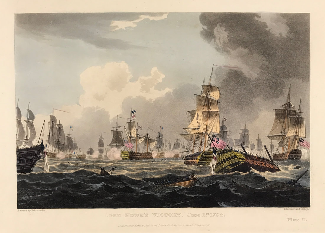
Back in December I shared with you Plate I from Lord Howes Victory for James Jenkins The Naval Achievements of Great Britain. Below is Plate II and below the print is the brief excerpt from the original written account as published with the aquatint plate. The French fleet of twenty-five sail of the line and fifteen frigates had sailed out of Brest in order to bring in homeward bound merchant ships. The fleet was discovered by the British on 28 May and battle was given on the 29th. The action was interrupted by fog and battle was not re-engaged until 1 June when the British fleet prevailed and captured seven vessels. Known as 'The Glorious First of June', this action was also known as the 'Third Battle of Ushant'. The British were commanded by Admiral Richard Howe, 1st Earl Howe (1726-99), and the French were commanded by Admiral Louis-Thomas Villaret de Joyeuse (1747-1812). The British defeat of the French was only a tactical victory, the objective of capturing a French grain convoy was not achieved. Above: Plate II: Lord Howe's Victory, June 1st 1794. Published Apr 1st 1816 at 48 Strand for J. Jenkins Navel Achievements. From The Naval achievements of Great Britain and Her Allies from 1793 to 1817 by J. Jenkins.
Excerpt from the written account as published: PL A T E II From the 29th May till the afternoon of the 31st, the fog continued with little intermission. About half-past one on the latter day, the enemy was discovered in a line about seven miles to leeward. Lord Howe immediately formed his line, but not being able to close with the enemy that day, he hauled his wind on the larboard tack; and the French admiral, following the example, brought the van of the British squadron abreast of the French centre: in this situation they remained the whole night. At five a. m. his lordship made the signal to bear up; at seven the two fleets were within three miles of each other. Lord Howe, after making the signal that he intended to pass through the enemy's line and engage to leeward, and that each ship was to steer for and engage the ship immediately opposite in the French line, bore away for the Montagne. The annexed view represents the Vengeur sinking, which, after having en gaged the Brunswick from the commencement of the action, was obliged to hoist the British jack as a token of submission, and implored assistance; but the boats of the Brunswick being shot away, she could afford them no aid. The Brunswick having lost her mizen-mast in the action, and drifted to leeward of the French retreating ships, was obliged to put away large to the northward from them; not seeing her chased by the enemy in that predicament, I flatter myself that she may arrive in safety at Ply mouth. All the other twenty-four ships of his Majesty's fleet re-assembled later in the day; and I am preparing to return with them, as soon as the captured ships of the enemy are secured, to Spithead. The material injury to his Majesty's ships is, I understand, confined principally to their masts and yards, which I conclude will be speedily replaced. I have not yet been able to collect regular accounts of the killed and wounded in the different ships. Captain Montague is the only officer of his rank who fell in the action. . . . How to Identify the Prints: The original prints from "The Naval Achievements of Great Britain. From the Year 1793 to 1817" are aquatint engravings on a medium weight wove paper. All the plates identify at bottom left Painted by T. Whitcombe and bottom right T. Sutherland (sculpt) who produced the aquatint engravings. Some plates were engraved by Jeakes and Bailey after Whitcombe. Each plate is accompanied by text pages describing the action, often with lists of ships captured or sunk, and excerpts from contemporary bulletins, dispatches, letters, and speeches. The first edition appeared in 1817. Early issues have watermarks of J. Whatman with the undated watermark IIS&S on some plates. The vignette title page was uncoloured in the first issue. The approx engraved image area of the plates are 7" x 10.25" (175mm x 260mm). Engraved plate mark area is approx 8.5 x 11.75 (215mm x 300mm). The folio sheet size is approx 11.5" x 14" (290mm x 355mm). You can see more prints from Jenkins The Naval Achievements of Great Britain, From the Year 1793 to 1817 HERE. If you're interested in a specific print and you cannot see it on my website please feel free to message me. |
LEARN ABOUT MAPS Where to Start? The Paper Earliest Maps Whats on the Paper? Rectum & Recto Marketing Devices Why Changing Faces? What is Ornamentation? Why all those lines? The Embellishment Story Illogical Prices Explained A Reference Library CLICK THE BOOK
Get the FREE Guide!
COLLECTING MAPS
Size Matters! Celestial Maps Strip Road Maps Sea Charts On the River of Life Projections The Sea Monsters Thematic Maps Town Plans Buy with Confidence. . .
More Top Tips for the Novice. Click the book to find out more . . .
COLLECTING PRINTS
Views of River Thames
Views of London Shipping & Craft Meet the Fairies Maritime Naval Military Battles Botanical Historic Churches Historic Views of Rome Archives
May 2024
|


