|
From this today you can get up close and personal with up to thirty historical globes as the British Library unveils its latest cutting edge project. This is the result of two years’ collaboration between BL imaging specialists and the digitization company Cyreal, developing bespoke equipment to photograph and digitize the globes from the library’s vast maps collection. 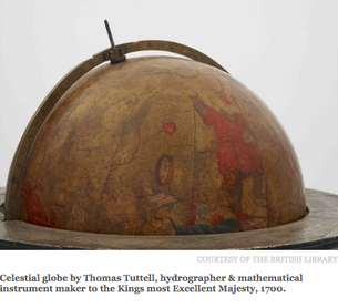 British Library's historical globes date from around 1600 to 1950 and represent three centuries of Western cartography. Today 26th March is release date and you can have a mooch around from the comfort of your own sofa, no need to step outside! The first seven globes to be made available on release include: • Possibly the earliest miniature ‘pocket’ globe, from 1679 by Joseph Moxon • Willem Janszoon Blaeu’s small table star globe of 1606 • The unique surviving star globe by Thomas Tuttell, 1700 • Johann Doppelmayr’s star globe from 1728 • Richard Cushee’s 1730 terrestrial globe with its unusually late inclusion of the island of California • Charles Price’s 1715 globe containing unusual annotations • Gabriel Wright and William Bardin’s 1783 globes You can find out more at the British Library website Collection Items - Enjoy & Stay Safe! |
LEARN ABOUT MAPS Where to Start? The Paper Earliest Maps Whats on the Paper? Rectum & Recto Marketing Devices Why Changing Faces? What is Ornamentation? Why all those lines? The Embellishment Story Illogical Prices Explained A Reference Library CLICK THE BOOK
Get the FREE Guide!
COLLECTING MAPS
Size Matters! Celestial Maps Strip Road Maps Sea Charts On the River of Life Projections The Sea Monsters Thematic Maps Town Plans Buy with Confidence. . .
More Top Tips for the Novice. Click the book to find out more . . .
COLLECTING PRINTS
Views of River Thames
Views of London Shipping & Craft Meet the Fairies Maritime Naval Military Battles Botanical Historic Churches Historic Views of Rome Archives
May 2024
|