RARE MAPS AND PRINTS
[email protected]
+44 7788 628706
  • About
  • Maps
    • British Isles
    • English Counties
    • Road Maps
    • River Thames
    • The Americas
    • Asia to Australia
    • Europe & Middle East
    • World & Hemispheres
    • Sea Charts
    • Military Battle Maps
  • Prints
    • British Topography >
      • Views England & Scotland
      • Views Wales
      • Views London
      • Views River Thames
    • Sporting
    • Amorial
    • Military & Naval
    • Portrait
    • Russian Art
    • Views Italy
  • Resources
    • Reference Books
  • Blog
  • The Colourist

London Map Fair 2019 Highlights & Catalogue

6/2/2019

Comments

 
it's that time of year again for map lovers to descend on the showcase event that is "The London Map Fair."  Held at the historic London venue of The Royal Geographic Society map enthusiast from around the world get the chance to attend the largest antique map fair in Europe. The event brings together around 40 of the leading national and international antiquarian map dealers as well as hundreds of visiting dealers, collectors, curators and map aficionados.
​
Highlights at this years fair provide for all levels of interest and budget.  The wonderful thing about the fair is the opportunity to see many examples of fine cartography from around the world.  You get the chance to meet other map enthusiasts and for those new to collecting you get the chance to hear talks about map collecting for beginners.  For those more serious collectors with deeper pockets these may take your fancy!

Picture
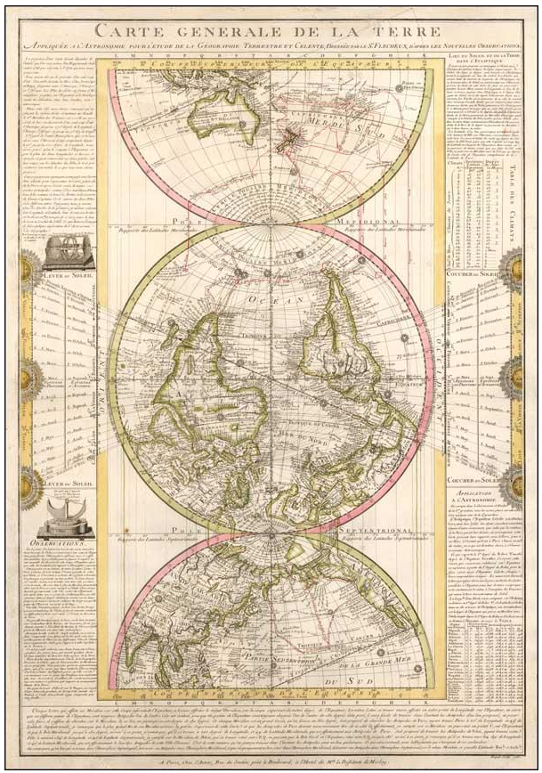
Carte Generale De La Terre Appliquee A L'Astronomie pour L'Etude de La Geographie Terrestre et Celeste, Dressee par Le Sr. Flecheux, D'Apres Les Nouvelles Observations. Paris / 1782 Striking World Map with Astronomical Instruments by Renowned French Inventor and Astronomer -- Includes A Remarkable Note on the Existence of Antarctica Fine, innovative world map by the astronomer, mathematician, and inventor Louis Flecheux. The map is surrounded by Flecheux’s theories about celestial phenomena and their courses relative to the earth’s surface, as well as descriptions of two of his inventions, the Loxocosme and the Quart de Cercle. (For Sale from Barry Lawrence Rudermann, Antique Maps Inc.) $24,500​

Picture
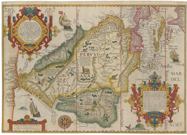
A classic 16th century map of South America LINSCHOTEN, Jan Huygen van. A highly decorative map of South America, engraved by Arnold Florent van Langeren for Linschoten's 'Itinerario', a manual for sailing to the East Indies. Orientated with north to the right, the West Indies and Florida are shown in some detail on the right; on the left Terra del Fuego, the landmass south of the Straits of Magellan, spreads out to fill the entire height of the map. (For sale from Altea Antique Maps & Charts) £7,850

Picture

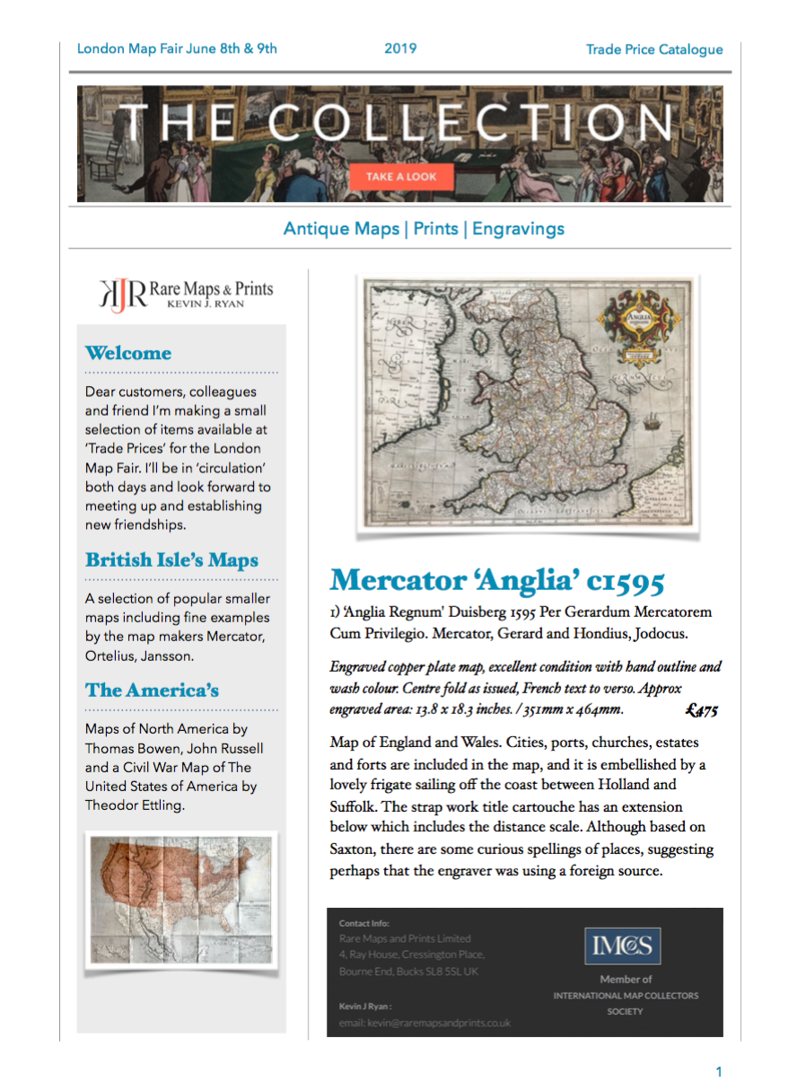
For those enthusiasts with a more modest budget I've produced a catalogue with a small  collection of items I'm making available more or less at 'trade prices' including maps from the British Isles my Mercator, Ortelius and Jansson.

Included are Maps of The America's by Thomas Bowen c1170 & 1784 along with a copy of The United States of North America the Civil War Map by Theodor Ettling c1861.

Always a favourite, Hemisphere maps includes editions by Guillaume Delisle, Antonio Zatta and John Rapkin and Allain Manesson Mallet along with a selection of small Charts & Plans and finally  English County Maps.

​You can download a copy of the catalogue directly by clicking the link below - Enjoy!

Rare Maps and Prints London Map Fair Catalogue


Comments

    LEARN ABOUT MAPS

    Where to Start?  
    The Paper  
    Earliest Maps  
    Whats on the Paper? 
    Rectum & Recto  
    Marketing Devices   
    Why Changing Faces?
    What is  Ornamentation?
    Why all those lines?
    The Embellishment Story

    Illogical Prices Explained
    ​A Reference Library
    ​
    CLICK THE BOOK
    Picture
    Get the FREE Guide!
    ​
    ​
    COLLECTING MAPS

    ​Size Matters!

    Celestial Maps
    Strip Road Maps
    Sea Charts
    On the River of Life
    Projections
    The Sea Monsters
    Thematic Maps
    ​Town Plans


    Buy with Confidence. . . 
    Picture
    More Top Tips for the Novice.  Click the book to find out more . . .
    COLLECTING PRINTS
    ​

    Views of River Thames
    Views of London
    Shipping & Craft
    ​Meet the Fairies
    Maritime Naval
    Military Battles
    Botanical 
    Historic Churches
    Historic Views of Rome

    Archives

    May 2024
    October 2023
    November 2022
    September 2022
    August 2022
    July 2022
    November 2021
    July 2021
    June 2021
    May 2021
    April 2021
    March 2021
    February 2021
    January 2021
    December 2020
    November 2020
    October 2020
    September 2020
    March 2020
    November 2019
    June 2019
    May 2019
    April 2019
    March 2019

Contact Info:     
Rare Maps and Prints Limited 
4, Ray House, Cressington Place,
​Bourne End, Bucks SL8 5SL UK 
                             
Kevin J Ryan :     

email: [email protected]         
​
    
          
Picture
Member of
​INTERNATIONAL MAP COLLECTORS SOCIETY 


    Maps & Prints Updates

Subscribe to List

Copyright © 2025 -  Rare Maps and Prints Limited  -  Raremapsandprints.co.uk   All Rights Reserved     Site Map     Terms & Conditions     Privacy Policy
  • About
  • Maps
    • British Isles
    • English Counties
    • Road Maps
    • River Thames
    • The Americas
    • Asia to Australia
    • Europe & Middle East
    • World & Hemispheres
    • Sea Charts
    • Military Battle Maps
  • Prints
    • British Topography >
      • Views England & Scotland
      • Views Wales
      • Views London
      • Views River Thames
    • Sporting
    • Amorial
    • Military & Naval
    • Portrait
    • Russian Art
    • Views Italy
  • Resources
    • Reference Books
  • Blog
  • The Colourist

    Join Our List

sign up
SHOP
Home
Shop
About
Updates
Contact
SOCIAL
Facebook
Twitter
Instagram
Proudly powered by Weebly