RARE MAPS AND PRINTS
[email protected]
+44 7788 628706
  • About
  • Maps
    • British Isles
    • English Counties
    • Road Maps
    • River Thames
    • The Americas
    • Asia to Australia
    • Europe & Middle East
    • World & Hemispheres
    • Sea Charts
    • Military Battle Maps
  • Prints
    • British Topography >
      • Views England & Scotland
      • Views Wales
      • Views London
      • Views River Thames
    • Sporting
    • Amorial
    • Military & Naval
    • Portrait
    • Russian Art
    • Views Italy
  • Resources
    • Reference Books
  • Blog
  • The Colourist

This is the 1734 Murillo Velarde map of the Philippines that sold for £260,000

11/1/2019

Comments

 
Back in September this map dubbed the 'Holy Grail' for collectors, was sold at Reeman Dansie Auction House for £260,000 - smashing a 138-year-old record. I had my eye on a couple of far lesser maps in this auction but this was the "jewel in the crown" of any enthusiast.  This and other maps in the auction were sold on behalf of the late Christopher Beresford-Jones, a prominent collector. The whole collection raising just short of £500k.
​
​If you didn't get the chance to see the Murillo Velarde map of the Philippines then the following pictures and images will be of great interest.
​

Picture

Picture
Picture

​Pedro de Murillo Velarde (1696-1753), engraved map - ‘ Carta Hydrographica y Chorographica delas Yslas Filipinas Dedicada al Rey Nuestro Señor Por el Mariscal d Campo D. Fernando Valdes Tamon Cavallº del Orden de Santiago de Govor. y Capn. General de dichas Yslas‘, ( The Murillo Velarde Map), engraved by Nicolás de la Cruz Bagay, published Manilla 1734, title cartouche at the top with the Royal Bourbon coat of arms, supported by two cherubs with trumpets, the title on a cloth held by two female allegorical figures bearing charts and instruments for navigation. 

A further ornate cartouche below, surmounted by a crowned lion wielding a sword and a candle, contains a brief history of the archipelago starting with Magellan's arrival and death in 1521, a description of the resources: ‘These islands are numerous and rich: they have gold, wax, sugar, honey, tobacco, ginger, indigo, Brazil wood (sfibucao), pitch, rice, salt, wheat, maize, lemons, oranges, bananas and many fruits and edible roots, palo Maria, tamarind, cassia-trees, Catbalogan seeds, dragon blood, lignum vitae, coconuts, bamboos, rattan and many kinds of palms, mahogany, tindalo and excellent timber for ships: horse, caraboas or buffaloes, cows, pigs, deer, chickens and much fish.’ There follows a description of the settlements, peoples, clergy and administration, all above an engraving of his ship the Victoria.

​The map is dissected and re-mounted on linen, 111cm x 120cm, early pen inscription verso - ‘map of the Philippine Islands’, folding map in later slip case. An extremely rare map and believed to be one of only around 15 extant examples of this first edition - the majority in International Institutions, and not all examples retain the flanking vignettes. Cited as the first scientific map of the Philippines and considered the most important Philippines map, it is celebrated for its detail and accuracy, it features shipping routes for trade with China and charts the course of Magellan’s navigations. 

The map features twelve flanking vignettes (Some shown here) encapsulating the essence of the Philippines, depicting different ethnic groups, customs, flora and fauna, also featured are miniature maps of Guajan (Guam), Manila, Samboangan and Cavite , all extensively annotated. The map influenced all subsequent Philippine maps for decades to follow but its influence was also notable on European maps.

​In recent times The Murillo Velarde map has been instrumental in the Philippines' efforts to assert territorial rights in the South China Sea. The map, together with others was used by the Philippines' team of experts to refute China's historic claim of ownership of the entire South China Sea. It features ‘Panacot’ (Scarborough Shoal) as well as ‘Los Bajos de Paragua’ (Spratly Isles). In 2016 the Permanent Court of Arbitration ruled in favour of the Philippines stating that China had "no historical rights". China however, rejected the ruling.

Provenance: Purchased from the map dealer Susanna Fisher, 1986 for £4,500. She had acquired the map from a trade source some years before and prior to that the map was believed to have been in private hands in the U.K. She states in correspondence that the ancient pen inscription in English to the reverse suggests that this map has been in the U.K. for a very long period of time.

Picture

Picture

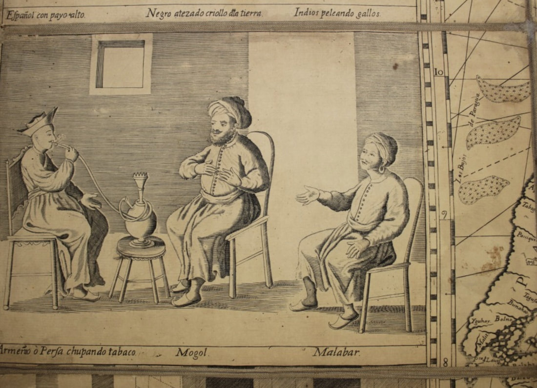
With thanks to Reeman Dansie Auctioneers & Valuers
Comments

    LEARN ABOUT MAPS

    Where to Start?  
    The Paper  
    Earliest Maps  
    Whats on the Paper? 
    Rectum & Recto  
    Marketing Devices   
    Why Changing Faces?
    What is  Ornamentation?
    Why all those lines?
    The Embellishment Story

    Illogical Prices Explained
    ​A Reference Library
    ​
    CLICK THE BOOK
    Picture
    Get the FREE Guide!
    ​
    ​
    COLLECTING MAPS

    ​Size Matters!

    Celestial Maps
    Strip Road Maps
    Sea Charts
    On the River of Life
    Projections
    The Sea Monsters
    Thematic Maps
    ​Town Plans


    Buy with Confidence. . . 
    Picture
    More Top Tips for the Novice.  Click the book to find out more . . .
    COLLECTING PRINTS
    ​

    Views of River Thames
    Views of London
    Shipping & Craft
    ​Meet the Fairies
    Maritime Naval
    Military Battles
    Botanical 
    Historic Churches
    Historic Views of Rome

    Archives

    May 2024
    October 2023
    November 2022
    September 2022
    August 2022
    July 2022
    November 2021
    July 2021
    June 2021
    May 2021
    April 2021
    March 2021
    February 2021
    January 2021
    December 2020
    November 2020
    October 2020
    September 2020
    March 2020
    November 2019
    June 2019
    May 2019
    April 2019
    March 2019

Contact Info:     
Rare Maps and Prints Limited 
4, Ray House, Cressington Place,
​Bourne End, Bucks SL8 5SL UK 
                             
Kevin J Ryan :     

email: [email protected]         
​
    
          
Picture
Member of
​INTERNATIONAL MAP COLLECTORS SOCIETY 


    Maps & Prints Updates

Subscribe to List

Copyright © 2025 -  Rare Maps and Prints Limited  -  Raremapsandprints.co.uk   All Rights Reserved     Site Map     Terms & Conditions     Privacy Policy
  • About
  • Maps
    • British Isles
    • English Counties
    • Road Maps
    • River Thames
    • The Americas
    • Asia to Australia
    • Europe & Middle East
    • World & Hemispheres
    • Sea Charts
    • Military Battle Maps
  • Prints
    • British Topography >
      • Views England & Scotland
      • Views Wales
      • Views London
      • Views River Thames
    • Sporting
    • Amorial
    • Military & Naval
    • Portrait
    • Russian Art
    • Views Italy
  • Resources
    • Reference Books
  • Blog
  • The Colourist

    Join Our List

sign up
SHOP
Home
Shop
About
Updates
Contact
SOCIAL
Facebook
Twitter
Instagram
Proudly powered by Weebly